Brownsville, Kentucky facts for kids
Quick facts for kids
Brownsville, Kentucky
|
|
|---|---|

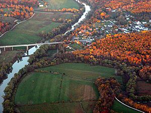
Aerial photograph of Brownsville
|
|

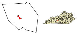
Location of Brownsville in Edmonson County, Kentucky.
|
|
| Country | United States |
| State | Kentucky |
| County | Edmonson |
| Established | 1826 |
| Area | |
| • Total | 2.62 sq mi (6.78 km2) |
| • Land | 2.61 sq mi (6.77 km2) |
| • Water | 0.01 sq mi (0.02 km2) |
| Elevation | 541 ft (165 m) |
| Population
(2020)
|
|
| • Total | 875 |
| • Density | 334.99/sq mi (129.33/km2) |
| Time zone | UTC-6 (Central (CST)) |
| • Summer (DST) | UTC-5 (CDT) |
| ZIP code |
42210
|
| Area code(s) | 270 & 364 |
| FIPS code | 21-10324 |
| GNIS feature ID | 0488045 |
Brownsville is a small city in Edmonson County, Kentucky, in the United States. It is the main town and the county seat (where the county government is located). Brownsville is also known as a certified Kentucky Trail Town.
In 2010, about 836 people lived here. By 2020, the population grew slightly to 875 people. Brownsville is part of the larger Bowling Green metropolitan area. It is also very close to the famous Mammoth Cave National Park.
Contents
Exploring Brownsville's Location
Brownsville is located near the middle of Edmonson County. The city's edge touches the western part of Mammoth Cave National Park, giving easy access to the Houchin Ferry Campground.
Roads and Travel
Two main roads, KY 70 and KY 259, go through Brownsville together as Main Street.
- KY 70 goes east for about 20 miles to Cave City. It goes west for about 27 miles to U.S. Route 231 at Aberdeen.
- KY 259 goes southeast for about 12 miles to U.S. Route 31W. It goes north for about 25 miles to Leitchfield.
Rivers and Land
Brownsville covers about 2.6 square miles (6.8 square kilometers) of land. Only a tiny part, about 0.01 square miles (0.02 square kilometers), is water. The city is located right on the Green River, which flows into the larger Ohio River.
Brownsville's Population Over Time
| Historical population | |||
|---|---|---|---|
| Census | Pop. | %± | |
| 1830 | 229 | — | |
| 1840 | 112 | −51.1% | |
| 1880 | 116 | — | |
| 1890 | 113 | −2.6% | |
| 1900 | 234 | 107.1% | |
| 1910 | 313 | 33.8% | |
| 1920 | 294 | −6.1% | |
| 1930 | 359 | 22.1% | |
| 1940 | 451 | 25.6% | |
| 1950 | 447 | −0.9% | |
| 1960 | 473 | 5.8% | |
| 1970 | 542 | 14.6% | |
| 1980 | 674 | 24.4% | |
| 1990 | 897 | 33.1% | |
| 2000 | 921 | 2.7% | |
| 2010 | 836 | −9.2% | |
| 2020 | 875 | 4.7% | |
| U.S. Decennial Census | |||
In 2000, there were 921 people living in Brownsville. About 26% of households had children under 18. The average household had about 2 people. The median age was 43 years old.
The Plain Community
In Peace Valley, Brownsville, there is a special Plain community. These folks use horses and buggies for transportation. This community has about 40 to 50 people and is connected to the community in Caneyville.
Schools in Brownsville
Brownsville is served by the Edmonson County Schools district. Here are the schools located in Brownsville:
- Edmonson County High School
- Edmonson County Middle School
- Edmonson County 5th/6th Center
Brownsville also has a public library called the Edmonson County Public Library. It's a great place to borrow books and learn new things!
Famous People from Brownsville
- Music promoter Denver D. Ferguson was born in Brownsville.
See also
 In Spanish: Brownsville (Kentucky) para niños
 | William L. Dawson |
 | W. E. B. Du Bois |
 | Harry Belafonte |

