Sebree, Kentucky facts for kids
Quick facts for kids
Sebree, Kentucky
|
|
|---|---|

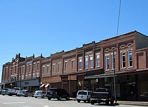
Business district of Sebree
|
|
| Nickname(s):
Railroad country
|
|

Location of Sebree in Webster County, Kentucky.
|
|
| Country | United States |
| State | Kentucky |
| County | Webster |
| Incorporated | 1871 |
| Area | |
| • Total | 2.95 sq mi (7.63 km2) |
| • Land | 2.94 sq mi (7.61 km2) |
| • Water | 0.01 sq mi (0.02 km2) |
| Elevation | 387 ft (118 m) |
| Population
(2020)
|
|
| • Total | 1,574 |
| • Estimate
(2022)
|
1,533 |
| • Density | 535.74/sq mi (206.88/km2) |
| Time zone | UTC-6 (Central (CST)) |
| • Summer (DST) | UTC-5 (CDT) |
| ZIP code |
42455
|
| Area code(s) | 270 |
| FIPS code | 21-69222 |
| GNIS feature ID | 0503138 |
Sebree is a city in Webster County, Kentucky, in the United States. It is known as a "home rule-class city," which means it has the power to govern itself in many local matters. In 2010, about 1,603 people lived there.
Contents
History of Sebree
Sebree started as a railroad town in 1868. This was just before the Louisville and Nashville Railroad arrived in October of that year. The people who founded the town were William Scott and Colonel E.G. Sebree.
How Sebree Got Its Name
The founders first wanted to name the town Springdale. This name came from the natural springs nearby. However, another town in Mason County was already called Springdale. So, they couldn't use that name.
The post office in the area was first called McBride. Later, it was renamed for Colonel Sebree in 1870. Colonel Sebree was the first president of the St. Bernard Mining Company. He helped bring the railroad to this part of Kentucky.
Early Life in Sebree
The Louisville and Nashville Railroad station was on the east side of the tracks. It had people working there day and night. At one time, Sebree was a busy place with about 40 businesses. These included hotels, shops, and stores.
The first church that welcomed all faiths was built in 1870. Soon after, Methodist, Catholic, and Baptist churches were also built. Sebree was also home to Sebree Springs. This was a summer resort and park run by G.L. Dial. Telephone service came to the town in 1895. Several factories that processed tobacco were also built here.
Historic Buildings
The historic Sebree Deposit Bank is still open today. It was built around 1890 and has a beautiful marble floor inside. Another old and interesting building in the area is the Queen Anne style McMullin-Warren House. It was built around 1901.
Geography of Sebree
Sebree is located at 37°36′29″N 87°31′46″W / 37.60806°N 87.52944°W. The city covers an area of about 1.6 square miles (4.1 square kilometers). All of this area is land.
Population of Sebree
| Historical population | |||
|---|---|---|---|
| Census | Pop. | %± | |
| 1880 | 360 | — | |
| 1890 | 959 | 166.4% | |
| 1900 | 1,477 | 54.0% | |
| 1910 | 1,500 | 1.6% | |
| 1920 | 1,258 | −16.1% | |
| 1930 | 940 | −25.3% | |
| 1940 | 1,109 | 18.0% | |
| 1950 | 1,158 | 4.4% | |
| 1960 | 1,139 | −1.6% | |
| 1970 | 1,092 | −4.1% | |
| 1980 | 1,516 | 38.8% | |
| 1990 | 1,510 | −0.4% | |
| 2000 | 1,558 | 3.2% | |
| 2010 | 1,603 | 2.9% | |
| 2020 | 1,574 | −1.8% | |
| 2022 (est.) | 1,533 | −4.4% | |
| U.S. Decennial Census | |||
In 2000, there were 1,558 people living in Sebree. There were 573 households, and 374 families. The population density was about 959.5 people per square mile.
About 23.3% of the people were under 18 years old. About 17.3% were 65 years old or older. The average age in the city was 36 years.
Climate in Sebree
The weather in Sebree has hot and humid summers. The winters are usually mild to cool. This type of weather is called a humid subtropical climate. On climate maps, it is shown as "Cfa."
Local Media
The Sebree Banner is a newspaper that comes out once a week. It is part of the CPC Newspaper Group. The newspaper says it is the oldest newspaper in Webster County. It was started in 1885.
Education in Sebree
The Webster County School District runs the public schools in the area. These schools include:
- Sebree Elementary
- Webster County Middle School
- Webster County High School
See also
 In Spanish: Sebree (Kentucky) para niños

