
Queen City, Missouri facts for kids
For the place nicknamed "the Queen City of the Ozarks", see Springfield, Missouri.
Quick facts for kids
Queen City, Missouri
|
|
|---|---|

City limits sign, Queen City, Missouri.
|
|

Location of Queen City, Missouri
|
|
| Country | United States |
| State | Missouri |
| County | Schuyler |
| Area | |
| • Total | 1.03 sq mi (2.67 km2) |
| • Land | 1.03 sq mi (2.67 km2) |
| • Water | 0.00 sq mi (0.00 km2) |
| Elevation | 997 ft (304 m) |
| Population
(2020)
|
|
| • Total | 562 |
| • Density | 546.16/sq mi (210.86/km2) |
| Time zone | UTC-6 (Central (CST)) |
| • Summer (DST) | UTC-5 (CDT) |
| ZIP code |
63561
|
| Area code(s) | 660 |
| FIPS code | 29-60356 |
| GNIS feature ID | 2396298 |
Queen City is a small city in Schuyler County, Missouri, in the United States. In 2020, about 562 people lived there. It is part of the Kirksville area.
Contents
History of Queen City

Queen City was started in May 1867 by Doctor George W. Wilson. He designed the town with a central square and fifteen other blocks around it. Dr. Wilson hoped the town would become "the Queen of the prairies," which is how it got its name.
He also built the first house in the new town. Henry Bartlett built the town's first hotel. By 1888, Queen City had many businesses. These included five general stores, two grocery stores, and two hardware stores. There were also two hotels, a jewelry store, a lumber yard, and a photography gallery. A music store and a barber shop served the people living there and on nearby farms.
Because it was located along the railroad, Queen City was a good place to ship goods. Many railroad ties and other wood products were sent from here. This wood came from the forests near the Chariton River. Farmers also shipped grain, livestock, and wool by train from the town. Queen City's first newspaper, The Transcript, started in November 1887. It was created by D.G. Swan.
Geography of Queen City
Queen City is located in Missouri. The city covers a total area of about 1.03 square miles (2.67 square kilometers). All of this area is land, with no water.
Population and People
| Historical population | |||
|---|---|---|---|
| Census | Pop. | %± | |
| 1880 | 357 | — | |
| 1890 | 377 | 5.6% | |
| 1900 | 770 | 104.2% | |
| 1910 | 701 | −9.0% | |
| 1920 | 697 | −0.6% | |
| 1930 | 619 | −11.2% | |
| 1940 | 646 | 4.4% | |
| 1950 | 554 | −14.2% | |
| 1960 | 599 | 8.1% | |
| 1970 | 588 | −1.8% | |
| 1980 | 783 | 33.2% | |
| 1990 | 704 | −10.1% | |
| 2000 | 638 | −9.4% | |
| 2010 | 598 | −6.3% | |
| 2020 | 562 | −6.0% | |
| U.S. Decennial Census | |||
Population in 2010
In 2010, there were 598 people living in Queen City. There were 256 households, which are groups of people living together. About 143 of these were families.
Most people in the city were White (99.0%). A small number were Native American (0.5%) or from two or more races (0.5%). About 1.3% of the population was Hispanic or Latino.
The average age of people in Queen City was 45.7 years old.
- About 20.9% of residents were under 18 years old.
- About 27.1% were 65 years old or older.
- More women lived in Queen City than men. About 54.2% of the population was female, and 45.8% was male.
Famous People From Queen City
- Farrell Dobbs (1907–1983) was a trade union leader and a candidate for U.S. President.
- Glenn Frank (1887-1940) was an educator.
Photo gallery
-
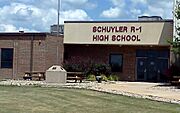
Schuyler County R-1 High School, located in Queen City.
-
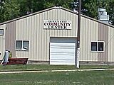
Queen City community building. It especially sees use during the towns annual Pioneer Days celebration.
-
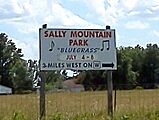
Sign directing attendees to Sally Mountain Park, site of a large Bluegrass music festival hosted annually by Rhonda Vincent and her family.


See also
 In Spanish: Queen City (Misuri) para niños
