Luray, Missouri facts for kids
Quick facts for kids
Luray, Missouri
|
|
|---|---|
|
Village
|
|

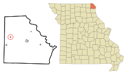
Location of Luray, Missouri
|
|
| Country | United States |
| State | Missouri |
| County | Clark |
| Area | |
| • Total | 0.20 sq mi (0.52 km2) |
| • Land | 0.20 sq mi (0.52 km2) |
| • Water | 0.00 sq mi (0.00 km2) |
| Elevation | 725 ft (221 m) |
| Population
(2020)
|
|
| • Total | 73 |
| • Density | 361.39/sq mi (139.69/km2) |
| Time zone | UTC-6 (Central (CST)) |
| • Summer (DST) | UTC-5 (CDT) |
| ZIP code |
63453
|
| Area code(s) | 660 |
| FIPS code | 29-44516 |
| GNIS feature ID | 2399202 |
Luray is a small village located in Clark County, Missouri, in the United States. In 2020, about 73 people lived there. It is part of a larger area that includes Fort Madison, Iowa and Keokuk, Iowa. This area is called a Micropolitan Statistical Area.
Contents
History of Luray
Luray was first planned out in 1837. When a town is "platted," it means its streets and building lots are officially mapped out. The exact reason for the name Luray is not fully known. Some believe it comes from a Native American word.
A post office opened in Luray in 1841. It served the community for 170 years. However, the Luray post office closed its doors on November 4, 2011.
Geography and Location
Luray is situated in Missouri, a state in the central United States. It is found along US Route 136. This road is about 6.5 miles west of another town called Kahoka, Missouri.
The border between Clark County and Scotland County, Missouri is about three miles west of Luray. A river called the North Wyaconda River flows nearby. It passes about three-quarters of a mile southwest of the village.
The United States Census Bureau measures land areas. They say that Luray covers a total area of 0.20 square miles (0.52 square kilometers). All of this area is land, with no water.
Population and People
Luray has seen its population change over many years. Here is a look at how many people have lived in the village during different census years:
| Historical population | |||
|---|---|---|---|
| Census | Pop. | %± | |
| 1880 | 217 | — | |
| 1890 | 246 | 13.4% | |
| 1900 | 194 | −21.1% | |
| 1910 | 163 | −16.0% | |
| 1920 | 164 | 0.6% | |
| 1930 | 197 | 20.1% | |
| 1940 | 202 | 2.5% | |
| 1950 | 184 | −8.9% | |
| 1960 | 154 | −16.3% | |
| 1970 | 149 | −3.2% | |
| 1980 | 175 | 17.4% | |
| 1990 | 70 | −60.0% | |
| 2000 | 102 | 45.7% | |
| 2010 | 99 | −2.9% | |
| 2020 | 73 | −26.3% | |
| U.S. Decennial Census | |||
What the 2010 Census Showed
In 2010, the census counted 99 people living in Luray. There were 37 households, which are groups of people living together. Out of these, 22 were families. The village had about 495 people per square mile.
Many households (37.8%) had children under 18 living with them. More than half (54.1%) were married couples. About 35.1% of all households were made up of individuals living alone. Some of these individuals (10.8%) were 65 years old or older.
The average age of people in Luray was 35.1 years. About a third of residents (33.3%) were under 18. A smaller group (5.1%) was between 18 and 24. Most adults were between 25 and 44 (32.4%) or 45 and 64 (20.4%). About 9.1% of the population was 65 or older. There were slightly more males (54.5%) than females (45.5%) in the village.
See also
- In Spanish: Luray (Misuri) for kids
 | Claudette Colvin |
 | Myrlie Evers-Williams |
 | Alberta Odell Jones |

