Kahoka, Missouri facts for kids
Quick facts for kids
Kahoka, Missouri
|
|
|---|---|

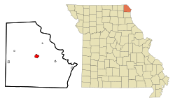
Location within Clark County and Missouri
|
|
| Country | United States |
| State | Missouri |
| County | Clark |
| Area | |
| • Total | 1.62 sq mi (4.19 km2) |
| • Land | 1.59 sq mi (4.11 km2) |
| • Water | 0.03 sq mi (0.08 km2) |
| Elevation | 696 ft (212 m) |
| Population
(2020)
|
|
| • Total | 1,961 |
| • Density | 1,236.44/sq mi (477.46/km2) |
| Time zone | UTC-6 (Central (CST)) |
| • Summer (DST) | UTC-5 (CDT) |
| ZIP code |
63445
|
| Area code(s) | 660 |
| FIPS code | 29-37790 |
| GNIS feature ID | 2395484 |
Kahoka is a city in the state of Missouri, United States. It is the main town, or county seat, of Clark County. This county is located in the very northeast part of Missouri. In 2020, about 1,961 people lived in Kahoka.
Contents
History of Kahoka
Kahoka was first planned out and established in 1858. The city got its name from an old Native American group called the Cahokia tribe. They were part of the Illiniwek or Illinois Confederacy. This tribe used to live on both sides of the Mississippi River in this area long ago.
Some important historic buildings in Kahoka are listed on the National Register of Historic Places. These include the Clark County Courthouse, the Col. Hiram M. Hiller House, and the Montgomery Opera House. These places are recognized for their special history and architecture.
Where is Kahoka Located?
Kahoka is found where two main roads meet. These roads are U.S. Route 136 and Missouri Route 81. The town of Wayland is about seven miles to the east. Luray is about 8.5 miles to the west. The Fox River flows past the city about one mile to the northeast.
The city covers a total area of about 1.60 square miles (4.14 km2). Most of this area, about 1.57 square miles (4.07 km2), is land. A small part, about 0.03 square miles (0.08 km2), is water.
Population and People
| Historical population | |||
|---|---|---|---|
| Census | Pop. | %± | |
| 1880 | 704 | — | |
| 1890 | 1,425 | 102.4% | |
| 1900 | 1,818 | 27.6% | |
| 1910 | 1,758 | −3.3% | |
| 1920 | 1,624 | −7.6% | |
| 1930 | 1,507 | −7.2% | |
| 1940 | 1,781 | 18.2% | |
| 1950 | 1,847 | 3.7% | |
| 1960 | 2,160 | 16.9% | |
| 1970 | 2,207 | 2.2% | |
| 1980 | 2,101 | −4.8% | |
| 1990 | 2,195 | 4.5% | |
| 2000 | 2,241 | 2.1% | |
| 2010 | 2,078 | −7.3% | |
| 2020 | 1,961 | −5.6% | |
| Decennial US Census | |||
Kahoka is part of a larger area called the Fort Madison–Keokuk Micropolitan Statistical Area. This means it's connected to the nearby cities of Fort Madison and Keokuk in Iowa.
What the 2010 Census Showed
In 2010, there were 2,078 people living in Kahoka. These people lived in 883 different homes. About 30% of these homes had children under 18 living there. The average age of people in the city was about 39.9 years old.
Most of the people living in Kahoka were White (98.5%). A small number were African American, Native American, or Asian. About 0.7% of the population identified as Hispanic or Latino.
Schools and Learning
The public schools in Kahoka are managed by the Clark County R-I School District. This district runs two elementary schools and one middle school. It also operates Clark County High School.
Kahoka also has a public library for everyone to use. It is called the H.E. Sever Memorial Branch Library.
Famous People from Kahoka
Many interesting people have come from Kahoka:
- Ralph Bell was a baseball player who played for the Chicago White Sox in 1912.
- William Bishop was a businessman and military officer. He also served as the State Treasurer of Missouri from 1865 to 1869.
- John Conner was a talented musician who played the marimba.
- Hiram Hiller, Jr. was a doctor and explorer who studied different cultures.
- Matt Murphy is known as a professional wrestler.
- Neil Smelser was a well-known sociologist, someone who studies how societies work.
- Ramo Stott was a stock car driver.
- Richard Webber became a federal judge.
- William Wheat was a U.S. Representative from Illinois.
See also
 In Spanish: Kahoka (Misuri) para niños
 | Georgia Louise Harris Brown |
 | Julian Abele |
 | Norma Merrick Sklarek |
 | William Sidney Pittman |

