Wayland, Missouri facts for kids
Quick facts for kids
Wayland, Missouri
|
|
|---|---|

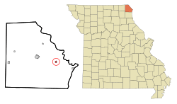
Location of Wayland, Missouri
|
|
| Country | United States |
| State | Missouri |
| County | Clark |
| Area | |
| • Total | 0.67 sq mi (1.74 km2) |
| • Land | 0.67 sq mi (1.74 km2) |
| • Water | 0.00 sq mi (0.00 km2) |
| Elevation | 535 ft (163 m) |
| Population
(2020)
|
|
| • Total | 408 |
| • Density | 606.24/sq mi (234.21/km2) |
| Time zone | UTC-6 (Central (CST)) |
| • Summer (DST) | UTC-5 (CDT) |
| ZIP code |
63472
|
| Area code(s) | 660 |
| FIPS code | 29-77920 |
| GNIS feature ID | 2397232 |
Wayland is a small city located in Clark County, Missouri, in the United States. In 2020, about 408 people lived there. It is part of a larger area called the Fort Madison-Keokuk Micropolitan Statistical Area, which includes parts of Iowa and Missouri.
History of Wayland
Wayland was officially started in 1880. The city was named after an early settler, Jerre Wayland. Before the city was laid out, a post office had already been open in Wayland since 1874.
A historic building called Sickles Tavern is in Wayland. It was added to the National Register of Historic Places in 1986. This means it's an important place that helps us understand the past.
Geography of Wayland
Wayland is situated on US Route 136. It is about seven miles east of Kahoka and 6.5 miles west of Alexandria. The Fox River flows along the western edge of the city.
The United States Census Bureau states that Wayland covers a total area of about 0.67 square miles (1.74 square kilometers). All of this area is land.
Population Changes in Wayland
The number of people living in Wayland has changed over the years. Here's a look at the population from 1910 to 2020:
| Historical population | |||
|---|---|---|---|
| Census | Pop. | %± | |
| 1910 | 384 | — | |
| 1920 | 355 | −7.6% | |
| 1930 | 385 | 8.5% | |
| 1940 | 380 | −1.3% | |
| 1950 | 350 | −7.9% | |
| 1960 | 384 | 9.7% | |
| 1970 | 467 | 21.6% | |
| 1980 | 498 | 6.6% | |
| 1990 | 391 | −21.5% | |
| 2000 | 425 | 8.7% | |
| 2010 | 533 | 25.4% | |
| 2020 | 408 | −23.5% | |
| U.S. Decennial Census | |||
Wayland's Population in 2010
In 2010, there were 533 people living in Wayland. These people lived in 233 households, and 138 of these were families. The city had about 795.5 people per square mile. There were 249 homes in total.
Most of the people in Wayland were White (98.5%). A small number were African American (0.2%), Asian (0.4%), or from other backgrounds. About 0.6% of the population was Hispanic or Latino.
About 29.2% of households had children under 18 living with them. Many households (43.3%) were married couples. The average household had 2.29 people, and the average family had 2.92 people.
The average age of people in Wayland was 38.9 years. About 24.6% of residents were under 18, and 15.9% were 65 or older. The population was almost evenly split between males (48.6%) and females (51.4%).
See also
 In Spanish: Wayland (Misuri) para niños
 | Sharif Bey |
 | Hale Woodruff |
 | Richmond Barthé |
 | Purvis Young |

