
Cass County, Illinois facts for kids
Quick facts for kids
Cass County
|
|
|---|---|

Cass County Courthouse
|
|

Location within the U.S. state of Illinois
|
|
 Illinois's location within the U.S. |
|
| Country | |
| State | |
| Founded | 1837 |
| Named for | Lewis Cass |
| Seat | Virginia |
| Largest city | Beardstown |
| Area | |
| • Total | 384 sq mi (990 km2) |
| • Land | 376 sq mi (970 km2) |
| • Water | 7.9 sq mi (20 km2) 2.1% |
| Population
(2020)
|
|
| • Total | 13,042 |
| • Density | 33.96/sq mi (13.113/km2) |
| Time zone | UTC−6 (Central) |
| • Summer (DST) | UTC−5 (CDT) |
| Congressional district | 15th |
Cass County is a county located in the state of Illinois, USA. It's home to about 13,042 people, based on the 2020 census. The main town and county seat is Virginia. You can also find the Jim Edgar Panther Creek State Fish and Wildlife Area here, which is a great place for nature lovers!
Contents
History of Cass County
Cass County was officially created in 1837. It was formed from a part of Morgan County.
The county was named after Lewis Cass. He was an important person in American history. Lewis Cass was a general during the War of 1812. He also served as the Governor of the Michigan Territory. Later, he became the United States Secretary of State in 1860. Just before Cass County was named, he was the Secretary of War for President Andrew Jackson.
-
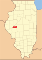
This map shows Cass County when it was first created.
-
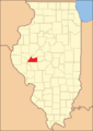
In 1845, the county's southern border was moved. This made it bigger, to its current size.


Geography of Cass County
Cass County covers a total area of about 384 square miles. Most of this area, about 376 square miles, is land. The rest, about 7.9 square miles, is water.
Neighboring Counties
- Mason County – to the northeast
- Menard County – to the east
- Sangamon County – to the southeast
- Morgan County – to the south
- Brown County – to the west
- Schuyler County – to the northwest
Protected Natural Areas
- A part of the Meredosia National Wildlife Refuge is located in Cass County.
Rivers in the County
- Illinois River
- Little Sangamon River
- Sangamon River
Main Roads and Highways
 US Route 67
 Illinois Route 78
 Illinois Route 100
 Illinois Route 125
Climate and Weather
| Weather chart for Virginia, Illinois | |||||||||||||||||||||||||||||||||||||||||||||||
|---|---|---|---|---|---|---|---|---|---|---|---|---|---|---|---|---|---|---|---|---|---|---|---|---|---|---|---|---|---|---|---|---|---|---|---|---|---|---|---|---|---|---|---|---|---|---|---|
| J | F | M | A | M | J | J | A | S | O | N | D | ||||||||||||||||||||||||||||||||||||
|
1.4
34
15
|
1.7
40
19
|
3.2
52
29
|
3.8
64
39
|
4.9
74
49
|
4.4
83
59
|
3.9
87
63
|
3.4
85
60
|
3.5
79
52
|
2.6
68
41
|
3.5
52
31
|
2.5
39
20
|
||||||||||||||||||||||||||||||||||||
| temperatures in °F precipitation totals in inches source: The Weather Channel |
|||||||||||||||||||||||||||||||||||||||||||||||
|
Metric conversion
|
|||||||||||||||||||||||||||||||||||||||||||||||
The weather in Cass County changes with the seasons. In Virginia, the county seat, average temperatures can be as low as 15°F (about -9°C) in January. They can reach highs of 87°F (about 31°C) in July.
The coldest temperature ever recorded was -28°F (about -33°C) in February 1934. The hottest was 114°F (about 46°C) in July 1954. The amount of rain also changes throughout the year. May usually gets the most rain, while January gets the least.
People of Cass County (Demographics)
| Historical population | |||
|---|---|---|---|
| Census | Pop. | %± | |
| 1840 | 2,981 | — | |
| 1850 | 7,253 | 143.3% | |
| 1860 | 11,325 | 56.1% | |
| 1870 | 11,580 | 2.3% | |
| 1880 | 14,493 | 25.2% | |
| 1890 | 15,963 | 10.1% | |
| 1900 | 17,222 | 7.9% | |
| 1910 | 17,372 | 0.9% | |
| 1920 | 17,896 | 3.0% | |
| 1930 | 16,537 | −7.6% | |
| 1940 | 16,425 | −0.7% | |
| 1950 | 15,097 | −8.1% | |
| 1960 | 14,539 | −3.7% | |
| 1970 | 14,219 | −2.2% | |
| 1980 | 15,084 | 6.1% | |
| 1990 | 13,437 | −10.9% | |
| 2000 | 13,695 | 1.9% | |
| 2010 | 13,642 | −0.4% | |
| 2020 | 13,042 | −4.4% | |
| 2023 (est.) | 12,596 | −7.7% | |
| US Decennial Census 1790-1960 1900-1990 1990-2000 2010 |
|||

In 2010, there were 13,642 people living in Cass County. These people lived in 5,270 households. About 3,561 of these were families. The county had about 36 people per square mile.
Most people in the county (86.3%) were white. About 3.1% were Black or African American. A small number were Asian (0.3%) or American Indian (0.3%). About 8.7% were from other races. About 16.8% of the population was of Hispanic or Latino background.
Many people in Cass County have German (22.6%), American (21.0%), Irish (10.6%), or English (9.5%) family backgrounds.
About 33.9% of households had children under 18 living with them. About half (51.1%) were married couples. The average age of people in the county was 38.7 years old.
The average income for a household was about $41,544 per year. For families, it was about $51,624 per year. About 12.9% of all people in the county lived below the poverty line. This included 14.2% of those under 18.
Education in Cass County
Cass County has several school districts that serve its communities:
- A C Central Community Unit School District 262
- Beardstown Community Unit School District 15
- Virginia Community Unit School District 64
Communities in Cass County
Here are some of the main towns and villages in Cass County:
| Community |
Community type |
Population | Total Area |
Water Area |
Land Area |
Pop. Density |
|
|---|---|---|---|---|---|---|---|
| Arenzville | village | 367 | 0.77 | 0.00 | 0.77 | 480 | |
| Ashland | village | 1,218 | 0.75 | 0.00 | 0.75 | 1,624 | |
| Beardstown | city | 5,951 | 3.65 | 0.03 | 3.62 | 1,620.41 | |
| Virginia (seat) | city | 1,514 | 1.27 | 0.06 | 1.21 | 1,254.35 | |
| Chandlerville | village | 527 | 0.79 | 0.00 | 0.79 | 670 | |
| Cass County | county | 13,042 | 384 | 7.9 | 376 | 34 |
Smaller Unincorporated Communities
These are smaller places in Cass County that are not officially cities or villages:
Past Communities
Some communities that once existed in Cass County are no longer separate places:
Townships in Cass County
Townships are smaller areas within the county, often used for local government:
- Arenzville
- Ashland
- Beardstown
- Bluff Springs
- Chandlerville
- Hagener
- Newmansville
- Panther Creek
- Philadelphia
- Sangamon Valley
- Virginia
See also
 In Spanish: Condado de Cass (Illinois) para niños
