
Schuyler County, Illinois facts for kids
Quick facts for kids
Schuyler County
|
|
|---|---|

Schuyler County Courthouse, Rushville
|
|

Location within the U.S. state of Illinois
|
|
 Illinois's location within the U.S. |
|
| Country | |
| State | |
| Founded | 1825 |
| Named for | Philip Schuyler |
| Seat | Rushville |
| Largest city | Rushville |
| Area | |
| • Total | 441 sq mi (1,140 km2) |
| • Land | 437 sq mi (1,130 km2) |
| • Water | 4.1 sq mi (11 km2) 0.9% |
| Population
(2020)
|
|
| • Total | 6,902 |
| • Density | 15.651/sq mi (6.043/km2) |
| Time zone | UTC−6 (Central) |
| • Summer (DST) | UTC−5 (CDT) |
| Congressional district | 15th |
Schuyler County is a place in the state of Illinois, USA. It's like a smaller area within the state, similar to a district. In 2020, about 6,902 people lived here. The main town and government center is Rushville.
Contents
History of Schuyler County
Schuyler County was created in 1825. It was formed from parts of Pike and Fulton counties. The county is named after Philip Schuyler. He was an important person who helped create the United States. He was a member of the Continental Congress and a Senator from New York.
In 1826, the county's main town moved. It went from Beardstown to Rushville. Beardstown is now in Cass County.
-
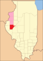
Schuyler County in 1825, showing areas that were not yet organized into counties.
-
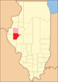
Schuyler County from 1826 to 1830, with McDonough County assigned to it.
-
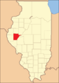
Schuyler County from 1830 to 1839, as McDonough County became organized.
-
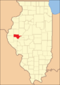
Schuyler County in 1839, after Brown County was created, giving Schuyler its current shape.


Geography and Nature
The US Census Bureau says Schuyler County covers about 441 square miles. Most of this area, about 437 square miles, is land. The rest, about 4.1 square miles, is water.
Climate and Weather Patterns
| Weather chart for Rushville, Illinois | |||||||||||||||||||||||||||||||||||||||||||||||
|---|---|---|---|---|---|---|---|---|---|---|---|---|---|---|---|---|---|---|---|---|---|---|---|---|---|---|---|---|---|---|---|---|---|---|---|---|---|---|---|---|---|---|---|---|---|---|---|
| J | F | M | A | M | J | J | A | S | O | N | D | ||||||||||||||||||||||||||||||||||||
|
1.6
32
15
|
1.9
38
20
|
3.1
50
30
|
3.9
63
41
|
5.1
73
51
|
3.9
82
61
|
3.9
87
65
|
3.5
84
63
|
3.6
78
54
|
3.3
66
43
|
3.2
50
31
|
2.4
37
20
|
||||||||||||||||||||||||||||||||||||
| temperatures in °F precipitation totals in inches source: The Weather Channel |
|||||||||||||||||||||||||||||||||||||||||||||||
|
Metric conversion
|
|||||||||||||||||||||||||||||||||||||||||||||||
In Rushville, the main town, temperatures change a lot. In January, the average low is about 15 degrees Fahrenheit. In July, the average high is about 87 degrees Fahrenheit. The coldest temperature ever recorded was -26 degrees Fahrenheit in February 1905. The hottest was 113 degrees Fahrenheit in July 1936.
The amount of rain and snow also changes. In January, it's usually about 1.55 inches. In May, it's much more, around 5.14 inches.
Main Roads and Highways
 U.S. Highway 24
 U.S. Highway 67
 Illinois Route 99
 Illinois Route 100
 Illinois Route 101
 Illinois Route 103
Neighboring Counties
Schuyler County shares borders with several other counties:
- Hancock County (to the northwest)
- McDonough County (to the north)
- Fulton County (to the northeast)
- Mason County (to the east)
- Cass County (to the southeast)
- Brown County (to the south)
- Adams County (to the southwest)
People and Population (Demographics)
| Historical population | |||
|---|---|---|---|
| Census | Pop. | %± | |
| 1840 | 6,972 | — | |
| 1850 | 10,573 | 51.6% | |
| 1860 | 14,684 | 38.9% | |
| 1870 | 17,419 | 18.6% | |
| 1880 | 16,249 | −6.7% | |
| 1890 | 16,013 | −1.5% | |
| 1900 | 16,129 | 0.7% | |
| 1910 | 14,852 | −7.9% | |
| 1920 | 13,285 | −10.6% | |
| 1930 | 11,676 | −12.1% | |
| 1940 | 11,430 | −2.1% | |
| 1950 | 9,613 | −15.9% | |
| 1960 | 8,746 | −9.0% | |
| 1970 | 8,135 | −7.0% | |
| 1980 | 8,365 | 2.8% | |
| 1990 | 7,498 | −10.4% | |
| 2000 | 7,189 | −4.1% | |
| 2010 | 7,544 | 4.9% | |
| 2020 | 6,902 | −8.5% | |
| 2023 (est.) | 6,733 | −10.8% | |
| US Decennial Census 1790-1960 1900-1990 1990-2000 2010 |
|||
In 2010, there were 7,544 people living in Schuyler County. These people lived in 3,040 homes, and 2,014 of these were families. On average, there were about 17 people per square mile.
Most people in the county were white (95.5%). About 3.2% were Black or African American. A small number were American Indian (0.2%) or Asian (0.1%). Some people were from other races (0.5%) or a mix of two or more races (0.5%). About 1.2% of the people were of Hispanic or Latino background.
Many people in the county have roots from different places. About 26.8% said their background was American. Around 20.2% had German ancestry. About 13.1% were English, and 12.0% were Irish.
In 2010, about 28.2% of homes had children under 18 living there. More than half, 53.5%, were married couples. The average age of people in the county was 43.6 years old.
Towns and Villages
Schuyler County has one city and several smaller villages and communities.
City
- Rushville (This is the county seat, where the main government offices are.)
Villages
Unincorporated Communities
These are smaller places that don't have their own local government.
Townships
Townships are smaller areas within the county, often used for local administration.
- Bainbridge
- Birmingham
- Brooklyn
- Browning
- Buena Vista
- Camden
- Frederick
- Hickory
- Huntsville
- Littleton
- Oakland
- Rushville
- Woodstock
Notable People from Schuyler County
- Mark Mitchell Bassett (1837–1910) – He was a lawyer and also involved in politics.
See also
 In Spanish: Condado de Schuyler (Illinois) para niños
