
McDonough County, Illinois facts for kids
Quick facts for kids
McDonough County
|
||
|---|---|---|

McDonough County Courthouse, 2006
|
||
|
||

Location within the U.S. state of Illinois
|
||
 Illinois's location within the U.S. |
||
| Country | ||
| State | ||
| Founded | January 25, 1826 | |
| Named for | Thomas Macdonough | |
| Seat | Macomb | |
| Largest city | Macomb | |
| Area | ||
| • Total | 590 sq mi (1,500 km2) | |
| • Land | 589 sq mi (1,530 km2) | |
| • Water | 0.8 sq mi (2 km2) 0.1% | |
| Population
(2020)
|
||
| • Total | 27,238 | |
| • Density | 46.2/sq mi (17.82/km2) | |
| Time zone | UTC−6 (Central) | |
| • Summer (DST) | UTC−5 (CDT) | |
| Congressional districts | 15th, 17th | |

McDonough County is a county in the state of Illinois, in the United States. In 2020, about 27,238 people lived there. Its main town, called the county seat, is Macomb. Macomb is also where Western Illinois University is located.
McDonough County is part of the Macomb, IL Micropolitan Statistical Area. This means it's an important area for jobs and daily life around Macomb.
Contents
History of McDonough County
McDonough County got its name from Thomas Macdonough. He was a brave naval officer. Macdonough won a very important battle called the Battle of Lake Champlain during the War of 1812.
This county was also part of something called the "Military Tract." This was land set aside by the United States Congress. It was given to soldiers who fought in the War of 1812.
-
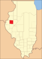
McDonough County when it was first created in 1826

Geography and Climate
Where is McDonough County Located?
The U.S. Census Bureau says McDonough County covers about 590 square miles. Most of this area, about 589 square miles, is land. Only a small part, about 0.8 square miles, is water.
A cool fact about the county is its shape. On a map, it looks like a perfect square! The main town, Macomb, is right in the middle of the county. The courthouse there is also almost exactly in the center.
Weather in McDonough County
| Weather chart for Macomb, Illinois | |||||||||||||||||||||||||||||||||||||||||||||||
|---|---|---|---|---|---|---|---|---|---|---|---|---|---|---|---|---|---|---|---|---|---|---|---|---|---|---|---|---|---|---|---|---|---|---|---|---|---|---|---|---|---|---|---|---|---|---|---|
| J | F | M | A | M | J | J | A | S | O | N | D | ||||||||||||||||||||||||||||||||||||
|
1.5
32
13
|
1.7
38
18
|
2.9
50
29
|
3.8
62
39
|
4.6
73
50
|
4.4
83
60
|
4.5
87
64
|
3.5
85
62
|
4
77
54
|
2.9
66
42
|
3.2
50
31
|
2.3
36
19
|
||||||||||||||||||||||||||||||||||||
| temperatures in °F precipitation totals in inches source: The Weather Channel |
|||||||||||||||||||||||||||||||||||||||||||||||
|
Metric conversion
|
|||||||||||||||||||||||||||||||||||||||||||||||
The weather in Macomb changes a lot throughout the year. In January, the average low temperature is about 13 degrees Fahrenheit. In July, the average high is around 87 degrees Fahrenheit.
The coldest temperature ever recorded was -30 degrees Fahrenheit in February 1905. The hottest was 113 degrees Fahrenheit in August 1934. Rain and snow also vary. May usually gets the most rain, while January gets the least.
Getting Around: Public Transit and Highways
There are a few ways to get around McDonough County.
- Go West Transit is a local bus system.
- The Macomb Amtrak station offers train travel.
Many important roads pass through the county:
 U.S. Route 67
 U.S. Route 136
 Illinois Route 9
 Illinois Route 41
 Illinois Route 61
 Illinois Route 95
 Illinois Route 110
 Illinois Route 336
Neighboring Counties
McDonough County shares borders with several other counties:
- Henderson County to the northwest
- Warren County to the north
- Fulton County to the east
- Schuyler County to the south
- Hancock County to the west
Population of McDonough County
| Historical population | |||
|---|---|---|---|
| Census | Pop. | %± | |
| 1840 | 5,308 | — | |
| 1850 | 7,616 | 43.5% | |
| 1860 | 20,069 | 163.5% | |
| 1870 | 26,509 | 32.1% | |
| 1880 | 27,970 | 5.5% | |
| 1890 | 27,467 | −1.8% | |
| 1900 | 28,412 | 3.4% | |
| 1910 | 26,887 | −5.4% | |
| 1920 | 27,074 | 0.7% | |
| 1930 | 27,329 | 0.9% | |
| 1940 | 26,944 | −1.4% | |
| 1950 | 28,199 | 4.7% | |
| 1960 | 28,928 | 2.6% | |
| 1970 | 36,653 | 26.7% | |
| 1980 | 37,467 | 2.2% | |
| 1990 | 35,244 | −5.9% | |
| 2000 | 32,913 | −6.6% | |
| 2010 | 32,612 | −0.9% | |
| 2020 | 27,238 | −16.5% | |
| 2023 (est.) | 26,839 | −17.7% | |
| U.S. Decennial Census 1790-1960 1900-1990 1990-2000 2010 |
|||
In 2010, about 32,612 people lived in McDonough County. There were over 13,000 households. The county had about 55 people per square mile.
Most people in the county were white (90.4%). There were also Black or African American people (5.0%), Asian people (1.8%), and people from other backgrounds. About 2.7% of the population was of Hispanic or Latino origin. The average age in the county was about 28.9 years old.
Communities in McDonough County
McDonough County has several towns and villages.
Cities
- Bushnell
- Colchester
- Macomb (This is the county seat)
Villages
- Bardolph
- Blandinsville
- Good Hope
- Industry
- Plymouth (partially in this county)
- Prairie City
- Sciota
- Tennessee
Census-designated places
These are areas that are like towns but not officially incorporated as cities or villages.
Other Unincorporated Places
These are smaller communities that are not officially part of a city or village.
- Colmar
- Doddsville
- Fandon
- Hills Grove
- New Philadelphia
- Scottsburg
- Vishnu Springs
- Walnut Grove
Townships
Counties in Illinois are divided into smaller areas called townships.
- Bethel Township
- Blandinsville Township
- Bushnell Township
- Chalmers Township
- Colchester Township
- Eldorado Township
- Emmet Township
- Hire Township
- Industry Township
- Lamoine Township
- Macomb Township
- Macomb City Township
- Mound Township
- New Salem Township
- Prairie City Township
- Sciota Township
- Scotland Township
- Tennessee Township
- Walnut Grove Township
Education in McDonough County
McDonough County has several schools and colleges for students of all ages.
- West Prairie Community Unit School District 103
- Bushnell Prairie City Community Unit School District 170
- Macomb Community Unit School District 185
- Spoon River College, which has a campus in Macomb
- Western Illinois University, a larger university
Images for kids
-

McDonough County Courthouse, 2006
See also
 In Spanish: Condado de McDonough para niños
