
Fulton County, Illinois facts for kids
Quick facts for kids
Fulton County
|
|
|---|---|

The old courthouse columns at Oak Hill Cemetery
|
|

Location within the U.S. state of Illinois
|
|
 Illinois's location within the U.S. |
|
| Country | |
| State | |
| Founded | 1823 |
| Named for | Robert Fulton |
| Seat | Lewistown |
| Largest city | Canton |
| Area | |
| • Total | 883 sq mi (2,290 km2) |
| • Land | 866 sq mi (2,240 km2) |
| • Water | 17 sq mi (40 km2) 1.9% |
| Population
(2020)
|
|
| • Total | 33,609 |
| • Density | 39/sq mi (15/km2) |
| Time zone | UTC−6 (Central) |
| • Summer (DST) | UTC−5 (CDT) |
| Congressional districts | 15th, 17th |
Fulton County is a county in the U.S. state of Illinois. It is located in the western part of the state. In 2020, about 33,609 people lived there.
The main town, called the county seat, is Lewistown. The biggest city in Fulton County is Canton. This county is part of a larger area that includes Peoria.
Contents
History of Fulton County
Fulton County was created in 1823. It was formed from a larger area called Pike County. The county is named after Robert Fulton. He was famous for inventing the first successful steamboat.
A well-known American poet and writer, Edgar Lee Masters, lived in Fulton County in the 1890s. He later wrote a famous book of poems called Spoon River Anthology in 1915. During World War II, Fulton County was home to Camp Ellis, a military base.
Each year, the county hosts the Spoon River Scenic Drive. This event happens on the first two weekends of October. It has been a tradition since 1968. Thousands of people from all over the country visit for this special drive.
Fulton County is also home to the Ogden-Fettie Site. This is a very important place for the ancient Havana Hopewell Native culture. It has the largest group of ancient mounds in Illinois. There are 35 mounds, built around 400 BC, arranged in a curved shape.
Geography and Nature
According to the US Census Bureau, Fulton County covers a total area of 883 square miles. Most of this area, about 866 square miles, is land. The remaining 17 square miles, or 1.9%, is water.
Fulton County is where you can find the Dickson Mounds Museum. This state museum teaches visitors about the daily life of Native American people who lived in the Illinois River valley long ago.
Climate and Weather in Fulton County
| Weather chart for Lewistown, Illinois | |||||||||||||||||||||||||||||||||||||||||||||||
|---|---|---|---|---|---|---|---|---|---|---|---|---|---|---|---|---|---|---|---|---|---|---|---|---|---|---|---|---|---|---|---|---|---|---|---|---|---|---|---|---|---|---|---|---|---|---|---|
| J | F | M | A | M | J | J | A | S | O | N | D | ||||||||||||||||||||||||||||||||||||
|
1.9
32
14
|
1.9
38
19
|
3
50
30
|
3.5
63
40
|
4.4
74
51
|
3.8
84
60
|
3.9
88
64
|
3.5
86
61
|
3.2
80
52
|
2.9
68
41
|
3.3
51
30
|
2.6
37
19
|
||||||||||||||||||||||||||||||||||||
| temperatures in °F precipitation totals in inches source: The Weather Channel |
|||||||||||||||||||||||||||||||||||||||||||||||
|
Metric conversion
|
|||||||||||||||||||||||||||||||||||||||||||||||
The weather in Lewistown, the county seat, changes a lot throughout the year. In January, the average low temperature is about 14°F. In July, the average high temperature is around 88°F.
The coldest temperature ever recorded was -30°F in January 1999. The hottest was 106°F in July 1983. The county gets the most rain in May, with about 4.43 inches. January is usually the driest month, with about 1.85 inches of rain.
Neighboring Counties
Fulton County shares its borders with several other counties:
- Warren County - to the northwest
- Knox County - to the north
- Peoria County - to the northeast
- Tazewell County - to the east
- Mason County - to the south
- Schuyler County - to the southwest
- McDonough County - to the west
Protected Natural Areas
Part of the Emiquon National Wildlife Refuge is located in Fulton County. This refuge helps protect wildlife and their natural homes.
Getting Around Fulton County
Major Roads
Several important highways pass through Fulton County, making it easy to travel. These include:
 US Route 24
 US Route 136
 Illinois Route 9
 Illinois Route 41
 Illinois Route 78
 Illinois Route 95
 Illinois Route 97
 Illinois Route 100
 Illinois Route 116
Airport
Fulton County has one public airport. It is called Ingersoll Airport (CTK) and is located in Canton.
People of Fulton County
| Historical population | |||
|---|---|---|---|
| Census | Pop. | %± | |
| 1830 | 1,841 | — | |
| 1840 | 13,142 | 613.9% | |
| 1850 | 22,508 | 71.3% | |
| 1860 | 33,338 | 48.1% | |
| 1870 | 38,291 | 14.9% | |
| 1880 | 41,240 | 7.7% | |
| 1890 | 43,110 | 4.5% | |
| 1900 | 46,201 | 7.2% | |
| 1910 | 49,549 | 7.2% | |
| 1920 | 48,163 | −2.8% | |
| 1930 | 43,983 | −8.7% | |
| 1940 | 44,627 | 1.5% | |
| 1950 | 43,716 | −2.0% | |
| 1960 | 41,954 | −4.0% | |
| 1970 | 41,890 | −0.2% | |
| 1980 | 43,687 | 4.3% | |
| 1990 | 38,080 | −12.8% | |
| 2000 | 38,250 | 0.4% | |
| 2010 | 37,069 | −3.1% | |
| 2020 | 33,609 | −9.3% | |
| 2023 (est.) | 32,541 | −12.2% | |
| US Decennial Census 1790-1960 1900-1990 1990-2000 2010 |
|||

In 2010, there were 37,069 people living in Fulton County. Most of the people, about 93.4%, were white. About 3.4% were black or African American. A small number of people were American Indian or Asian.
Many families lived in the county. About 29.3% of households had children under 18 living with them. The average age of people in Fulton County was 41.9 years old.
Towns and Villages in Fulton County
Cities
- Canton
- Cuba
- Farmington
- Lewistown (the county seat)
Town
Villages
- Avon
- Banner
- Bryant
- Dunfermline
- Ellisville
- Fairview
- Ipava
- Liverpool
- London Mills
- Marietta
- Norris
- Smithfield
- St. David
- Table Grove
- Vermont
Unincorporated Communities
These are smaller communities that are not officially part of a city or village:
- Babylon
- Beaty
- Bernadotte
- Blyton
- Breeds
- Brereton
- Checkrow
- Depler Springs
- Duncan Mills
- Enion
- Fiatt
- Gilchrist
- Leesburg
- Little America
- Manley
- Maples Mill
- Marbletown
- Middlegrove
- Monterey
- Poverty Ridge
- Rawalts
- Sepo
- Seville
- Summum
Images for kids
-
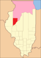
Fulton County between 1823 and 1825, including unorganized territory temporarily attached.
-
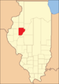
Fulton County, reduced to its current size in 1825, its unorganized territory formed into new counties.


See also
 In Spanish: Condado de Fulton (Illinois) para niños
