
Warren County, Illinois facts for kids
Quick facts for kids
Warren County
|
|
|---|---|

Warren County Courthouse in Monmouth
|
|

Location within the U.S. state of Illinois
|
|
 Illinois's location within the U.S. |
|
| Country | |
| State | |
| Founded | 1825 |
| Named for | Joseph Warren |
| Seat | Monmouth |
| Largest city | Monmouth |
| Area | |
| • Total | 543 sq mi (1,410 km2) |
| • Land | 542 sq mi (1,400 km2) |
| • Water | 0.6 sq mi (2 km2) 0.1% |
| Population
(2020)
|
|
| • Total | 16,835 |
| • Density | 31.004/sq mi (11.971/km2) |
| Time zone | UTC−6 (Central) |
| • Summer (DST) | UTC−5 (CDT) |
| Congressional districts | 15th, 17th |
Warren County is a county located in the state of Illinois in the United States. In 2020, about 16,835 people lived here. The main town and county seat (where the county government is) is Monmouth.
Contents
History of Warren County
Warren County was created in 1825. It was formed from a much larger area called Pike County. Before 1825, Pike County covered all the land in Illinois north and west of the Illinois River. Later, in 1841, Henderson County was formed from the western part of Warren County.
The county is named after Dr. Joseph Warren. He was a hero who died in 1775 during the Battle of Bunker Hill. Many believe he was the first officer to die in the Revolutionary War.
The building used today as the county courthouse was finished in 1895. It is made of red Portage stone.
-
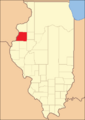
Warren County when it was first created in 1825, up to 1831.
-
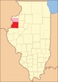
Between 1831 and 1835, Mercer County was temporarily part of Warren County.
-

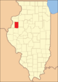
Warren County between 1835 and 1841.
-
Warren County in 1841, after Henderson County was created. This is its current size.


Geography and Climate
Warren County covers a total area of about 543 square miles. Most of this area, 542 square miles, is land. Only a small part, about 0.6 square miles, is water.
Weather in Warren County
| Weather chart for Monmouth, Illinois | |||||||||||||||||||||||||||||||||||||||||||||||
|---|---|---|---|---|---|---|---|---|---|---|---|---|---|---|---|---|---|---|---|---|---|---|---|---|---|---|---|---|---|---|---|---|---|---|---|---|---|---|---|---|---|---|---|---|---|---|---|
| J | F | M | A | M | J | J | A | S | O | N | D | ||||||||||||||||||||||||||||||||||||
|
1.6
31
15
|
1.7
37
21
|
2.9
49
30
|
3.8
63
41
|
4.3
73
51
|
4.3
81
60
|
4.3
85
64
|
4
83
62
|
3.5
77
54
|
3
65
43
|
2.7
49
32
|
2.3
35
20
|
||||||||||||||||||||||||||||||||||||
| temperatures in °F precipitation totals in inches source: The Weather Channel |
|||||||||||||||||||||||||||||||||||||||||||||||
|
Metric conversion
|
|||||||||||||||||||||||||||||||||||||||||||||||
In Monmouth, the county seat, temperatures usually range from 15°F in January to 85°F in July. However, the coldest temperature ever recorded was -27°F in February 1905. The hottest was 110°F in July 1936. The county gets the most rain in July, with about 4.33 inches. January is usually the driest month, with about 1.62 inches of rain.
Neighboring Counties
Warren County shares its borders with these other counties:
- Mercer County (to the north)
- Knox County (to the east)
- Fulton County (to the southeast)
- McDonough County (to the south)
- Henderson County (to the west)
Population Information
| Historical population | |||
|---|---|---|---|
| Census | Pop. | %± | |
| 1830 | 308 | — | |
| 1840 | 6,739 | 2,088.0% | |
| 1850 | 8,176 | 21.3% | |
| 1860 | 18,336 | 124.3% | |
| 1870 | 23,174 | 26.4% | |
| 1880 | 22,933 | −1.0% | |
| 1890 | 21,281 | −7.2% | |
| 1900 | 23,163 | 8.8% | |
| 1910 | 23,313 | 0.6% | |
| 1920 | 21,488 | −7.8% | |
| 1930 | 21,745 | 1.2% | |
| 1940 | 21,286 | −2.1% | |
| 1950 | 21,981 | 3.3% | |
| 1960 | 21,587 | −1.8% | |
| 1970 | 21,595 | 0.0% | |
| 1980 | 21,943 | 1.6% | |
| 1990 | 19,181 | −12.6% | |
| 2000 | 18,735 | −2.3% | |
| 2010 | 17,707 | −5.5% | |
| 2020 | 16,835 | −4.9% | |
| 2023 (est.) | 16,185 | −8.6% | |
| U.S. Decennial Census 1790-1960 1900-1990 1990-2000 2010 |
|||
In 2010, there were 17,707 people living in Warren County. There were 6,918 households, with 4,617 of them being families. On average, there were about 32.6 people per square mile.
Most people in the county (91.3%) were white. About 1.7% were black or African American, and 0.5% were Asian. People of Hispanic or Latino origin made up 8.4% of the population. Many residents have German (25.2%), Irish (14.7%), English (11.3%), or Swedish (10.0%) backgrounds.
About 29.6% of households had children under 18 living with them. The average age of people in the county was 39.6 years. The average income for a household was $41,636. About 13.4% of the population lived below the poverty line. This included 18.1% of those under 18 years old.
Transportation
Bus Services
- Burlington Trailways provides bus services.
- You can find more information about bus stops at List of intercity bus stops in Illinois.
Main Roads
Several important highways pass through Warren County:
 U.S. Highway 34
 U.S. Highway 67
 Illinois Route 94
 Illinois Route 116
 Illinois Route 135
 Illinois Route 164
Law Enforcement
Law enforcement in Warren County is handled by different groups:
State Police
- The Illinois State Police District 14 is located in Macomb.
County Sheriff
- The Warren County Sheriff's Office helps keep the peace in the county.
- Fun fact: In the 2018 movie "Halloween," the local sheriff's car says "Warren County Sheriff's Department." This suggests the fictional town of Haddonfield is in Warren County!
City Police
Volunteer Police
- The Warren County/Monmouth Auxiliary Police Corps is made up of volunteers who help out.
Communities in Warren County
City
Villages
- Alexis (partly in Mercer County)
- Kirkwood
- Little York
- Roseville
Unincorporated Communities
These are smaller places that are not officially cities or villages:
Townships
Warren County is also divided into smaller areas called townships:
- Berwick
- Cold Brook
- Ellison
- Floyd
- Greenbush
- Hale
- Kelly
- Lenox
- Monmouth
- Point Pleasant
- Roseville
- Spring Grove
- Sumner
- Swan
- Tompkins
See also
 In Spanish: Condado de Warren (Illinois) para niños
