Noble County, Indiana facts for kids
Quick facts for kids
Noble County
|
|
|---|---|

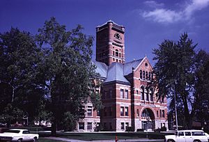
Noble County Courthouse in Albion
|
|

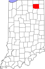
Location within the U.S. state of Indiana
|
|
 Indiana's location within the U.S. |
|
| Country | |
| State | |
| Founded | February 7, 1835 (authorized) 1836 (organized) |
| Named for | Governor Noah Noble |
| Seat | Albion |
| Largest city | Kendallville |
| Area | |
| • Total | 417.43 sq mi (1,081.1 km2) |
| • Land | 410.84 sq mi (1,064.1 km2) |
| • Water | 6.59 sq mi (17.1 km2) 1.58%% |
| Population
(2020)
|
|
| • Total | 47,457 |
| • Estimate
(2023)
|
47,430 |
| • Density | 115.7/sq mi (44.7/km2) |
| Time zone | UTC−5 (Eastern) |
| • Summer (DST) | UTC−4 (EDT) |
| Congressional district | 3rd |
| Indiana county number 57 | |
Noble County is a county located in the state of Indiana, USA. It is like a special region within the state. In 2020, about 47,457 people lived here.
The main town where the county government is located is Albion. Noble County is divided into 13 smaller areas called townships. These townships help provide local services to the people living there.
Contents
Noble County's Past: A Look at Its History
Noble County started its official government in 1836. The county was named after an important family in Indiana politics. One famous member was Noah Noble, who was the governor of Indiana from 1831 to 1837. His brother, James, was Indiana's first senator after it became a state.
The first settlers in Noble County came from New England. These people were often called "Yankees." They were descendants of English Puritans who settled New England in the 1600s. They moved west to the Northwest Territory in the early 1800s. This big move happened after the Erie Canal was finished and the Black Hawk War ended. These early settlers helped found the towns of Kendallville and Albion.
Noble County's Location and Landscape
Noble County is in the northeast part of Indiana. The land is mostly low and gently rolling. You'll find many lakes and wet areas here. Most of the land is used for farming or for towns and cities.
The highest point in the county is Sand Hill. It's about 1,073 feet (327 meters) above sea level. This makes it the second-highest named spot in Indiana. The Elkhart River also flows through the northwest part of the county.
According to a 2010 survey, Noble County covers about 417.43 square miles (1,081.1 square kilometers). Most of this area, about 410.84 square miles (1,064.1 square kilometers), is land. The rest, about 6.59 square miles (17.1 square kilometers), is water.
Neighboring Counties Around Noble County
- LaGrange County - north
- Steuben County - northeast
- DeKalb County - east
- Allen County - southeast
- Whitley County - south
- Kosciusci County - southwest
- Elkhart County - northwest
Cities in Noble County
Towns in Noble County
Smaller Communities in Noble County
- Ari
- Bakertown
- Bear Lake
- Brimfield
- Burr Oak
- Cosperville
- Ege
- Green Center
- Grismore
- Indian Village
- Kimmell (a special type of community)
- LaOtto
- Lisbon
- Merriam
- Ormas
- Port Mitchell
- Swan
- Wakeville Village
- Washington Center
- Wawaka
- Wayne Center
- Wilmot
- Wolf Lake
Townships Providing Local Services
- Albion
- Allen
- Elkhart
- Green
- Jefferson
- Noble
- Orange
- Perry
- Sparta
- Swan
- Washington
- Wayne
- York
Main Roads in Noble County
Lakes in Noble County
- Axel Lake
- Bartley Lake
- Big Lake
- Bixler Lake
- Bristol Lake
- Cree Lake
- Crooked Lake (part)
- Diamond Lake
- Eagle Lake
- Engle Lake
- Gordy Lake
- Grannis Lake
- Jones Lake
- Knapp Lake
- Latta Lake
- Lindsey Lake
- Little Long Lake
- Loon Lake (part)
- Lower Long Lake
- Marl Lake
- Millers Lake
- Moore Lake
- Moss Lake
- Mud
- Pleasant Lake
- Port Mitchell Lake
- Roudy Lake
- Round Lake
- Schockopee Lake
- Skinner Lake
- Sparta Lake
- Summit Lake
- Sylvan Lake
- Upper Long Lake
- Waldron Lake
- West Lakes
- Wible Lake
Protected Natural Areas
- Chain O'Lakes State Park
- Eagle Lake Wetland Conservation Area
- Hammer Wetland Nature Preserve
- Mallard Roost Wetland Conservation Area
- Mendenhall Wetland Conservation Area
- Pioneer Trails Camp
- Rome City Wetland Conservation Area
- West Lakes Conservation Inc Tract
Weather and Climate in Noble County
| Weather chart for Albion, Indiana | |||||||||||||||||||||||||||||||||||||||||||||||
|---|---|---|---|---|---|---|---|---|---|---|---|---|---|---|---|---|---|---|---|---|---|---|---|---|---|---|---|---|---|---|---|---|---|---|---|---|---|---|---|---|---|---|---|---|---|---|---|
| J | F | M | A | M | J | J | A | S | O | N | D | ||||||||||||||||||||||||||||||||||||
|
2.1
31
14
|
1.8
35
18
|
2.9
46
27
|
3.7
58
37
|
3.7
70
48
|
4.4
79
58
|
3.8
83
62
|
3.6
81
59
|
3.5
74
51
|
2.8
62
40
|
3.3
48
31
|
2.9
36
21
|
||||||||||||||||||||||||||||||||||||
| temperatures in °F precipitation totals in inches source: The Weather Channel |
|||||||||||||||||||||||||||||||||||||||||||||||
|
Metric conversion
|
|||||||||||||||||||||||||||||||||||||||||||||||
The weather in Albion, the county seat, changes a lot throughout the year. In January, the average low temperature is about 14°F (minus 10°C). In July, the average high temperature is about 83°F (28°C).
The coldest temperature ever recorded in January was -24°F (minus 31°C) in 1994. The hottest temperature ever recorded was 103°F (39°C) in June 1988. The amount of rain and snow also changes. February usually has the least precipitation, while June has the most.
Noble County's Population: Demographics
| Historical population | |||
|---|---|---|---|
| Census | Pop. | %± | |
| 1840 | 2,702 | — | |
| 1850 | 7,946 | 194.1% | |
| 1860 | 14,915 | 87.7% | |
| 1870 | 20,389 | 36.7% | |
| 1880 | 22,956 | 12.6% | |
| 1890 | 23,359 | 1.8% | |
| 1900 | 23,533 | 0.7% | |
| 1910 | 24,009 | 2.0% | |
| 1920 | 22,470 | −6.4% | |
| 1930 | 22,404 | −0.3% | |
| 1940 | 22,776 | 1.7% | |
| 1950 | 25,075 | 10.1% | |
| 1960 | 28,162 | 12.3% | |
| 1970 | 31,382 | 11.4% | |
| 1980 | 35,443 | 12.9% | |
| 1990 | 37,877 | 6.9% | |
| 2000 | 46,275 | 22.2% | |
| 2010 | 47,536 | 2.7% | |
| 2020 | 47,457 | −0.2% | |
| 2023 (est.) | 47,430 | −0.2% | |
| US Decennial Census 1790-1960 1900-1990 1990-2000 2010-2013 2018 |
|||
In 2010, there were 47,536 people living in Noble County. These people lived in about 17,355 homes. Most of the people were white (92.5%). Smaller groups included black or African American, Asian, and American Indian people. About 9.6% of the population was of Hispanic or Latino background.
Many households (35.9%) had children under 18 living with them. The average household had about 2.69 people. The average age of people in the county was 37.1 years old.
Schools in Noble County
School Districts Serving Noble County Students
- Central Noble Community School Corporation
- East Noble School Corporation
- Smith–Green Community Schools
- West Noble School Corporation
See also
 In Spanish: Condado de Noble (Indiana) para niños
 | Valerie Thomas |
 | Frederick McKinley Jones |
 | George Edward Alcorn Jr. |
 | Thomas Mensah |

