LaOtto, Indiana facts for kids
Quick facts for kids
LaOtto, Indiana
|
|
|---|---|
 |
|
| Country | United States |
| State | Indiana |
| County | Noble |
| Township | Swan |
| Elevation | 873 ft (266 m) |
| Time zone | UTC-5 (Eastern (EST)) |
| • Summer (DST) | UTC-4 (EDT) |
| ZIP code |
46763
|
| Area code(s) | 260 |
| FIPS code | 18-42138 |
| GNIS feature ID | 2830481 |
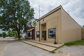
LaOtto (sometimes spelled Laotto) is a small community in Noble County, Indiana, in the U.S. state of Indiana. It is an unincorporated community, meaning it is not officially a city or town with its own local government. LaOtto is located in Swan Township.
You can find LaOtto west of where Indiana State Road 3 and Indiana State Road 205 meet. It's about 16 miles north of Fort Wayne. It is also close to Kendallville and Auburn. Because of its location, many people who live in LaOtto work in these nearby cities. This makes LaOtto a "bedroom community."
Contents
History of LaOtto
LaOtto was first settled in the 1830s. People moved north from Fort Wayne, Indiana along a path called the Mongoquinong Trail. This trail later became Lima Plank Road.
How LaOtto Got Its Name
LaOtto has had a few different names over the years!
- From 1856 to 1861, it was called Simon's Corners. This name came from the local U.S. Post Office. The first Postmaster, John Miller, named it after himself.
- Later, it became Simonsville.
- From 1872 to 1875, it was known as Grand Rapids Crossing. This was because two railroad lines crossed there: the north-south Grand Rapids & Indiana Railroad and the east-west Eel River Railroad. The railroad companies did not like the name Simonsville.
- Finally, in 1875, a Lutheran minister named Rev. B.F. Shultz suggested the name LaOtto. The Noble County commissioners approved this name, and it has been LaOtto ever since.
LaOtto and the Underground Railroad
Even though LaOtto is a small community, it played a part in the fight against slavery. The LaOtto Wesleyan Church was a safe place for enslaved people. It was a stop on the Underground Railroad during the 1850s and 1860s. Pastor Aaron Worth was a "conductor" on this secret network. He helped guide enslaved people to freedom.
Changes to State Road 3
Originally, Indiana State Road 3 went right through LaOtto. But in 1990, a new bypass was built. Now, State Road 3 goes just east of the community.
Schools in LaOtto
Children living in LaOtto attend schools that are part of the East Noble School Corporation.
- Elementary School: Students in Kindergarten through 5th grade now go to Avilla Elementary School. This school is located in Avilla, Indiana. LaOtto Elementary School closed in 2008.
- Middle School: Students in 6th, 7th, and 8th grades attend East Noble Middle School. This school is in Kendallville, Indiana.
- High School: Students in 9th through 12th grades go to East Noble High School. This high school is also located in Kendallville, Indiana.
 | Laphonza Butler |
 | Daisy Bates |
 | Elizabeth Piper Ensley |


