Van Buren County, Michigan facts for kids
Quick facts for kids
Van Buren County
|
||
|---|---|---|
|
||
|
||
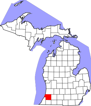
Location within the U.S. state of Michigan
|
||
 Michigan's location within the U.S. |
||
| Country | ||
| State | ||
| Founded | 1829 (created) 1837 (organized) |
|
| Named for | Martin Van Buren | |
| Seat | Paw Paw | |
| Largest city | South Haven | |
| Area | ||
| • Total | 1,090 sq mi (2,800 km2) | |
| • Land | 607 sq mi (1,570 km2) | |
| • Water | 482 sq mi (1,250 km2) 44%% | |
| Population
(2020)
|
||
| • Total | 75,587 | |
| • Density | 124/sq mi (48/km2) | |
| Time zone | UTC−5 (Eastern) | |
| • Summer (DST) | UTC−4 (EDT) | |
| Congressional district | 4th | |
Van Buren County is a county in the state of Michigan. In 2020, about 75,587 people lived there. The main town and county seat is Paw Paw. The county was created in 1829 and officially started working in 1837.
Contents
History of Van Buren County
Van Buren County was named after Martin Van Buren. He became President later on. Before that, he was the Secretary of State and Vice President for President Andrew Jackson. This is why Van Buren is one of Michigan's "Cabinet counties". These counties are named after people who were in the President's cabinet.
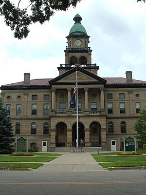
The Van Buren County Courthouse is a very old building. It was designed by a famous architect named Claire Allen. Building started on September 2, 1901.
Geography of Van Buren County
Van Buren County covers about 1,090 square miles. About 607 square miles of this is land. The other 482 square miles (44%) is water.
Most of the county is farmland with many small towns. Areas near Kalamazoo County are becoming more like suburbs. This means more homes and businesses are being built there. Many lakes in the county have homes around them. Some people live there all year, while others have cottages for vacations. These vacationers often come from Chicago. Tourism is a big business here, especially near Lake Michigan.
Rivers in Van Buren County
Neighboring Counties
By land
- Allegan County (north)
- Kalamazoo County (east)
- St. Joseph County (southeast)
- Cass County (south)
- Berrien County (southwest)
By water
- Lake County, Illinois (west)
Parks and Natural Areas
Van Buren County has many beautiful parks and natural places to explore:
- Dunes Parkway: This is an 84-acre area with dunes in Covert Township.
- Hamilton Township Coastal Plain Marsh Nature Sanctuary: A 79-acre preserve with a special type of marsh. It is owned by the Michigan Nature Association.
- Jeptha Lake Fen Preserve: A 49-acre preserve in Columbia Township.
- Kal-Haven Trail: A long trail for walking and biking. It was made from an old railroad line. It goes from Kalamazoo to South Haven.
- Keeler State Game Area: A 400-acre area for wildlife and outdoor activities.
- North Point Park: This park has tall dunes on 17 acres along Lake Michigan.
- Ross Preserve: A large 1,449-acre preserve with coastal plain marsh. The Nature Conservancy owns it.
- Van Buren State Park
- Van Buren Trail State Park: This park is right next to the Kal-Haven Trail.
Transportation in Van Buren County
Major Roads
 I-94
I-94 I-196
I-196 BL I-196
 US 31
US 31 M-40
M-40 M-51
M-51 M-140
M-140- M-152
 A-2
A-2 M-43
M-43
Public Transit
- Pere Marquette (Amtrak train) (a passenger train service)
- Van Buren Public Transit (local bus service)
Railroads
- Amtrak (passenger trains)
- CSX Transportation (freight trains)
- Norfolk Southern (freight trains, uses the Michigan Line owned by Amtrak)
- West Michigan Railroad (freight trains)
Population of Van Buren County
| Historical population | |||
|---|---|---|---|
| Census | Pop. | %± | |
| 1830 | 5 | — | |
| 1840 | 1,910 | 38,100.0% | |
| 1850 | 5,800 | 203.7% | |
| 1860 | 15,224 | 162.5% | |
| 1870 | 28,829 | 89.4% | |
| 1880 | 30,807 | 6.9% | |
| 1890 | 30,541 | −0.9% | |
| 1900 | 33,274 | 8.9% | |
| 1910 | 33,185 | −0.3% | |
| 1920 | 30,715 | −7.4% | |
| 1930 | 32,637 | 6.3% | |
| 1940 | 35,111 | 7.6% | |
| 1950 | 39,184 | 11.6% | |
| 1960 | 48,395 | 23.5% | |
| 1970 | 56,173 | 16.1% | |
| 1980 | 66,814 | 18.9% | |
| 1990 | 70,060 | 4.9% | |
| 2000 | 76,263 | 8.9% | |
| 2010 | 76,258 | 0.0% | |
| 2020 | 75,587 | −0.9% | |
| 2023 (est.) | 75,798 | −0.6% | |
| US Decennial Census 1790-1960 1900-1990 1990-2000 2010-2018 |
|||
In 2010, the population of Van Buren County was 76,258 people. This was almost the same as in 2000. The county had about 125 people per square mile.
Most people in the county are White (82.7%). About 3.9% are Black or African American, and 10.2% are Hispanic or Latino.
The average age in the county was 40 years old. About 25.5% of the people were under 18 years old.
Communities in Van Buren County
Cities
- Bangor
- Gobles
- Hartford
- South Haven (partially in this county)
Villages
- Bloomingdale
- Breedsville
- Decatur
- Lawrence
- Lawton
- Mattawan
- Paw Paw (the county seat)
Unincorporated Communities
These are smaller places that are not officially cities or villages.
- Almena
- Berlamont
- Columbia
- Corwin
- Covert
- Crystal Beach
- Fritzburg
- Glendale
- Grand Junction
- Keeler
- Kibbie
- Kendall
- Lake-of-the-Woods
- Lacota
- Maple Grove Corners
- McDonald
- Mentha (a ghost town, meaning it's mostly abandoned)
- North Lake
- Pine Grove Mills
- Roth Valley
- Sister Lakes
- Stoughton Corners
- Tea Pot Dome
- Toquin
- West Bangor
Townships
Townships are local government areas within the county.
- Almena Township
- Antwerp Township
- Arlington Township
- Bangor Township
- Bloomingdale Township
- Columbia Township
- Covert Township
- Decatur Township
- Geneva Township
- Hamilton Township
- Hartford Township
- Keeler Township
- Lawrence Township
- Paw Paw Township
- Pine Grove Township
- Porter Township
- South Haven Township
- Waverly Township
Former Townships
- Clinch Township existed from 1837 to 1842. It was then split into Waverly Township and Almena Township.
See also
 In Spanish: Condado de Van Buren (Míchigan) para niños
 | James Van Der Zee |
 | Alma Thomas |
 | Ellis Wilson |
 | Margaret Taylor-Burroughs |


