Bloomingdale, Michigan facts for kids
Quick facts for kids
Bloomingdale, Michigan
|
|
|---|---|
|
Village
|
|

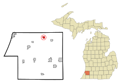
Location of Bloomingdale within Van Buren County, Michigan
|
|
| Country | United States |
| State | Michigan |
| County | Van Buren |
| Area | |
| • Total | 1.16 sq mi (3.01 km2) |
| • Land | 1.14 sq mi (2.94 km2) |
| • Water | 0.03 sq mi (0.07 km2) |
| Elevation | 732 ft (223 m) |
| Population
(2020)
|
|
| • Total | 513 |
| • Density | 451.98/sq mi (174.44/km2) |
| Time zone | UTC-5 (Eastern (EST)) |
| • Summer (DST) | UTC-4 (EDT) |
| ZIP code |
49026
|
| Area code(s) | 269 |
| FIPS code | 26-09220 |
| GNIS feature ID | 2398139 |
Bloomingdale is a small village located in Van Buren County, which is part of the state of Michigan. In 2020, about 513 people lived here. It is the main town in Bloomingdale Township.
Years ago, in the 1930s, oil was found in Bloomingdale. This made people think the village would grow much bigger. However, the oil eventually ran out, and the village stayed small.
Today, Bloomingdale is a special stop on the Kal-Haven Trail. This trail is popular for biking and walking. The village has a park called Augustus Haven Park with a Depot Museum, which is a great place for trail users to stop for a picnic.
Contents
History of Bloomingdale
Bloomingdale was first started in 1855. A year later, in 1856, a post office was opened there. The town was officially mapped out in 1870. It became an official village in 1881.
Geography of Bloomingdale
Bloomingdale is a small place, covering about 1.17 square miles (3.01 square kilometers). Most of this area is land, with a tiny bit of water.
People of Bloomingdale
Bloomingdale is home to a diverse group of people. Here's how the population has changed over the years:
| Historical population | |||
|---|---|---|---|
| Census | Pop. | %± | |
| 1880 | 292 | — | |
| 1890 | 380 | 30.1% | |
| 1900 | 379 | −0.3% | |
| 1910 | 501 | 32.2% | |
| 1920 | 486 | −3.0% | |
| 1930 | 386 | −20.6% | |
| 1940 | 553 | 43.3% | |
| 1950 | 465 | −15.9% | |
| 1960 | 471 | 1.3% | |
| 1970 | 496 | 5.3% | |
| 1980 | 537 | 8.3% | |
| 1990 | 503 | −6.3% | |
| 2000 | 528 | 5.0% | |
| 2010 | 454 | −14.0% | |
| 2020 | 513 | 13.0% | |
| U.S. Decennial Census | |||
Bloomingdale's Population in 2010
In 2010, there were 454 people living in Bloomingdale. The village had 172 households, which are groups of people living together. Many households had children under 18. The average age of people in the village was about 38 years old.
Famous People from Bloomingdale
Some interesting people have come from Bloomingdale:
- Bill Killefer (1887–1960) was a professional baseball player. He also worked as a coach and manager. He was part of the 1915 Philadelphia Phillies team that won the National League championship.
- Red Killefer (1885–1958) was another baseball player, known for playing outfield. He played for the Detroit Tigers and is in the Pacific Coast League Hall of Fame.
- David Wayne (1914–1995) was a well-known actor. He had a long career of over 50 years in movies and on stage.
See also
 In Spanish: Bloomingdale (Míchigan) para niños

