St. Philippe, Illinois facts for kids
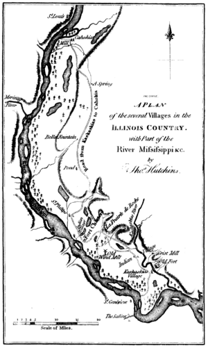
St. Philippe was a village that used to be in Monroe County, Illinois, in the United States. A Frenchman named Philip Francois Renault started it around 1723. This was during the time when France had colonies in North America. St. Philippe was built in a smart spot near the tall bluffs next to the Mississippi River. This area is a big flat plain called the "American Bottom". The village was only about three miles north of Fort de Chartres, a French fort. Over many years, St. Philippe and the fort faced a lot of serious floods. Because of this, both were left empty before 1765. After the British took over this area, many French people moved west to places like Ste. Genevieve and St. Louis in Missouri.
Contents
History of St. Philippe
French Beginnings
In 1719, Philip Francois Renault came to this area from a place in France called Picardy. He was a friend of the French King Louis XV. The King gave Renault a large piece of land to look for valuable minerals. However, he didn't find as much as he hoped.
Instead, Renault started the village of St. Philippe along the Mississippi River. Soon, his village grew lots of extra crops. These crops were sold to towns and villages further south in French Louisiana. Those southern towns really needed the grain from the Illinois Country. St. Philippe was built in a good spot on the rich, flat land near the Mississippi River. The extra food grown by the French farmers, called habitants, helped feed New Orleans and other communities in the lower Louisiana Territory. They couldn't grow these crops well because of their different climate.
An inspector named D'Artaguette visited the area in the early 1700s. He wrote about how great the land was:
"This country is one of the most beautiful in all Louisiana. Every kind of grain and vegetables are produced here in the greatest abundance.... They have, also, large numbers of oxen, cows, sheep, etc., upon the prairies. Poultry is abundant, and fish plentiful. So that, in fact, they lack none of the necessaries or conveniences of life."
Over time, the farmers didn't add nutrients back to the soil. This made the soil less fertile. Also, more people moved to the village, and there wasn't enough land for everyone. Because of this, some villagers moved to the west side of the Mississippi River. Around 1750, they started a new town called Ste. Genevieve in what is now Missouri. This new town quickly became a farming community, much like St. Philippe.
British Takeover
The French and Indian War (also known as the Seven Years' War) ended with Britain winning. In the Treaty of Paris signed in 1763, Britain gained control of all French lands east of the Mississippi River, except for New Orleans. The British soldiers didn't fully arrive until 1765.
To avoid living under British rule, many French residents of St. Philippe moved. They crossed the Mississippi River to towns like Ste. Genevieve and St. Louis. These towns were now part of Spanish Louisiana, due to a secret agreement called the Treaty of Fontainebleau. Also, King George III made a rule called the Royal Proclamation of 1763. This rule set aside all the land west of the Appalachian Mountains and east of the Mississippi as an Indian Reserve. The King wanted to stop settlers from the British Colonies from moving into these lands.
American Revolution Era
During the American Revolutionary War, an American leader named George Rogers Clark captured Prairie du Rocher. This was part of his plan that also led to the capture of Vincennes, Indiana. It is said that Clark's actions caused some of the remaining French settlers to move to the Spanish-controlled lands west of the Mississippi. This left very few French people in Prairie du Rocher. Many of the new settlers in the area were soldiers from Clark's campaign. They were convinced the land was good because of stories about the rich soil in the area now called American Bottom.
Environmental Challenges
Flooding Problems
People cut down many trees along both sides of the Mississippi River. This deforestation caused the river banks to collapse easily. When the banks collapsed, large areas of land, including the village of St. Philippe, would flood often.
Fort de Chartres
Fort de Chartres was a French military fort built in 1718. It was about three miles south of St. Philippe. The fort was also a trading post located at the site of a Native American village.
In the 1900s, the fort was named an Illinois state historic site. Parts of it were rebuilt. Due to state budget cuts, the fort was closed for a while in 2008. Since the fall of 2009, the fort has been open to visitors again.
Why the Village Was Left Empty
St. Philippe was located in the floodplain of the American Bottom. It suffered from very bad seasonal flooding. Because of these floods, the village was eventually left empty before 1765. The nearby Fort de Chartres was also abandoned for the same reasons.
 | John T. Biggers |
 | Thomas Blackshear |
 | Mark Bradford |
 | Beverly Buchanan |


