
Monroe County, Illinois facts for kids
Quick facts for kids
Monroe County
|
|||||
|---|---|---|---|---|---|

Monroe County Courthouse in Waterloo
|
|||||
|
|||||

Location within the U.S. state of Illinois
|
|||||
 Illinois's location within the U.S. |
|||||
| Country | |||||
| State | |||||
| Founded | 1816 | ||||
| Named for | James Monroe | ||||
| Seat | Waterloo | ||||
| Largest city | Waterloo | ||||
| Area | |||||
| • Total | 398 sq mi (1,030 km2) | ||||
| • Land | 385 sq mi (1,000 km2) | ||||
| • Water | 13 sq mi (30 km2) 3.3% | ||||
| Population
(2020)
|
|||||
| • Total | 34,962 | ||||
| • Estimate
(2023)
|
34,957 |
||||
| • Density | 87.84/sq mi (33.92/km2) | ||||
| Time zone | UTC−6 (Central) | ||||
| • Summer (DST) | UTC−5 (CDT) | ||||
| Congressional district | 12th | ||||


Monroe County is a county in the state of Illinois. It's located in the southern part of Illinois, an area sometimes called "Little Egypt". In 2020, about 34,962 people lived here. The biggest city and the main government center is Waterloo. Monroe County is also part of the larger St. Louis area, which includes parts of Missouri.
Contents
History of Monroe County
Long before Europeans arrived, Indigenous peoples lived along the Mississippi River for thousands of years. French explorers and Jesuit priests met groups like the Kaskaskia and Cahokia, who were part of the Illiniwek confederacy.
Early European Settlements
The first European town in this area was St. Philippe. It was started in 1723 by Philippe François Renault, a French nobleman. This community was very good at farming. They grew so much food that they sold extra grains to the French colony in Louisiana. This food was very important for the people living there.
Monroe County was officially created in 1816. It was the 8th county formed in what was then the Illinois Territory. It was made from parts of Randolph and St. Clair counties.
Naming the County
The county was named after James Monroe. He had just been the United States Secretary of War and became President later that same year. The first county seat (government center) was Harrisonville. It was named after William Henry Harrison, who was a governor and later a president.
In 1825, Waterloo became the new county seat. Sadly, the original towns of St. Philippe and Harrisonville were later covered by the Mississippi River. This happened because too many trees were cut down along the riverbanks during the time of steamboats. Without the trees, the banks collapsed, making the river wider and causing more floods.
The boundaries of Monroe County have changed a little over time. Some areas were added from St. Clair County in 1825 and 1827. Since then, the borders have mostly stayed the same.
-
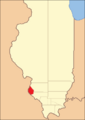
Monroe County from the time of its creation to 1825
-
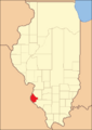
Monroe County between 1825 and 1827
-
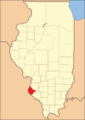
In 1827, an adjustment to Monroe County's border with St. Clair brought it to its present territory


Geography and Nature
Monroe County covers about 398 square miles. Most of this (385 square miles) is land, and 13 square miles (about 3.3%) is water.
The western part of the county, along the Mississippi River, is a flat area called the American Bottom. The eastern part is also mostly flat and used to be prairie (grassland). In between these areas, there are tall bluffs made of limestone. This area has a special type of landscape called Karst topography. It has many sinkholes, caves, and springs. These bluffs are part of what people call the "Illinois Ozarks." The county has around 500 limestone sinkholes, often covered with thick woods, which makes the area look unique.
Climate and Weather
| Weather chart for Waterloo, Illinois | |||||||||||||||||||||||||||||||||||||||||||||||
|---|---|---|---|---|---|---|---|---|---|---|---|---|---|---|---|---|---|---|---|---|---|---|---|---|---|---|---|---|---|---|---|---|---|---|---|---|---|---|---|---|---|---|---|---|---|---|---|
| J | F | M | A | M | J | J | A | S | O | N | D | ||||||||||||||||||||||||||||||||||||
|
2.3
38
20
|
2.4
44
25
|
3.7
55
35
|
4.2
66
45
|
4
76
55
|
4
84
64
|
4.3
89
68
|
3.1
87
66
|
3.4
80
59
|
3.1
69
47
|
4.2
54
36
|
3.4
42
25
|
||||||||||||||||||||||||||||||||||||
| temperatures in °F precipitation totals in inches source: The Weather Channel |
|||||||||||||||||||||||||||||||||||||||||||||||
|
Metric conversion
|
|||||||||||||||||||||||||||||||||||||||||||||||
In Waterloo, the county seat, temperatures usually range from about 20°F (about -7°C) in January to 89°F (about 32°C) in July. The lowest temperature ever recorded was -18°F (-28°C) in December 1989. The highest was 107°F (42°C) in August 1962. The county gets between 2.32 and 4.25 inches of rain each month.
Neighboring Counties
Monroe County shares borders with several other counties:
- St. Clair County - to the northeast
- Randolph County - to the southeast
- Ste. Genevieve County, Missouri - to the south
- Jefferson County, Missouri - to the west
- St. Louis County, Missouri - to the northwest
Population and People
| Historical population | |||
|---|---|---|---|
| Census | Pop. | %± | |
| 1820 | 1,537 | — | |
| 1830 | 2,000 | 30.1% | |
| 1840 | 4,481 | 124.1% | |
| 1850 | 7,679 | 71.4% | |
| 1860 | 12,832 | 67.1% | |
| 1870 | 12,982 | 1.2% | |
| 1880 | 13,682 | 5.4% | |
| 1890 | 12,948 | −5.4% | |
| 1900 | 13,847 | 6.9% | |
| 1910 | 13,508 | −2.4% | |
| 1920 | 12,839 | −5.0% | |
| 1930 | 12,369 | −3.7% | |
| 1940 | 12,754 | 3.1% | |
| 1950 | 13,282 | 4.1% | |
| 1960 | 15,507 | 16.8% | |
| 1970 | 18,831 | 21.4% | |
| 1980 | 20,117 | 6.8% | |
| 1990 | 22,422 | 11.5% | |
| 2000 | 27,619 | 23.2% | |
| 2010 | 32,957 | 19.3% | |
| 2020 | 34,962 | 6.1% | |
| 2023 (est.) | 34,957 | 6.1% | |
| U.S. Decennial Census 1790-1960 1900-1990 1990-2000 2010-2013 2020 |
|||
In 2010, there were about 32,957 people living in Monroe County. Most people (98%) were white. Other groups included Asian, American Indian, and African American people. About 1.4% of the population was of Hispanic or Latino background. Many people in the county have German (53.9%), Irish (16.5%), or English (9.6%) heritage.
About 34.7% of households had children under 18. Most households (62.9%) were married couples. The average age of people in the county was 41 years old. The average income for a family was about $80,832. About 4.5% of the population lived below the poverty line.
Transportation and Travel
Monroe County has several important roads and rivers that help people travel and transport goods.
Major Highways
 Interstate 255: This highway connects to the larger interstate system. It provides access to St. Louis and other areas.
 U.S. Highway 50: This highway also connects to the interstate system and helps people get to St. Louis.
 Illinois Route 3: This is the main north-south road in Monroe County. It runs through towns like Columbia and Waterloo.
 Illinois Route 156: This road goes from Valmeyer in the west through Waterloo to Hecker in the east.
 Illinois Route 158: This road links the area with central and eastern St. Clair County.
 Illinois Route 159: This is another important north-south road in the eastern part of the county.
Public Transportation
There is a public bus service called MetroBus. The 502X Waterloo-Columbia express bus runs from Waterloo, through Columbia, to the MetroLink station in East St. Louis. This helps people travel to the wider St. Louis area.
Rivers

- Mississippi River: This major river forms the western border of Monroe County.
- Jefferson Barracks Bridge: This bridge crosses the Mississippi River northwest of Columbia and carries Interstate 255.
- Kaskaskia River: This river is also important, but there are no bridges or ferries over it directly within Monroe County.
Rail and Air Travel
While railroads were once very important, the main train line through Monroe County is no longer used. However, Union Pacific freight trains still run through the western part of the county, near the bluffs. These tracks are only for cargo, not passengers.
For air travel, there is a small airfield called Sackman Field located west of Columbia.
Communities in Monroe County
Monroe County has several cities, villages, and smaller communities.
Cities
Villages
Unincorporated Communities
- Ames
- Burksville
- Burksville Station
- Chalfin Bridge
- Fountain
- Harrisonville
- Madonnaville
- Merrimac
- Monroe City
- New Hanover
- Renault
- St. Joe
- Tipton
- Wartburg
Former Settlement
Education in Monroe County
Monroe County has several school districts that serve its communities:
- Columbia Community Unit School District 4
- Valmeyer Community Unit School District 3
- Waterloo Community Unit School District 5
See also
 In Spanish: Condado de Monroe (Illinois) para niños
