Columbia, Illinois facts for kids
Quick facts for kids
Columbia
|
|||
|---|---|---|---|

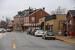
Downtown Columbia
|
|||
|
|||
| Motto(s):
Good for business, good for life
|
|||

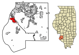
Location of Columbia in Monroe County, Illinois.
|
|||

Location of Illinois in the United States
|
|||
| Country | |||
| State | |||
| County | St. Clair and Monroe | ||
| Founded | 1859 | ||
| Area | |||
| • Total | 10.38 sq mi (26.88 km2) | ||
| • Land | 10.32 sq mi (26.74 km2) | ||
| • Water | 0.06 sq mi (0.14 km2) | ||
| Elevation | 453 ft (138 m) | ||
| Population
(2020)
|
|||
| • Total | 10,999 | ||
| • Density | 1,065.48/sq mi (411.37/km2) | ||
| Time zone | UTC−6 (CST) | ||
| • Summer (DST) | UTC−5 (CDT) | ||
| ZIP Code(s) |
62236
|
||
| Area code(s) | 618 | ||
| FIPS code | 17-15833 | ||
| GNIS feature ID | 2393604 | ||
| Wikimedia Commons | Columbia, Illinois | ||
Columbia is a city in Illinois, a state in the United States. It is mostly in Monroe County. A small part of it is in St. Clair County.
Columbia is about 12 miles (19 km) south of St. Louis, Missouri. In 2020, about 10,999 people lived there.
Contents
History of Columbia
Columbia became a town in 1859. Before that, different Native American groups lived in the area for 12,000 years. The first group that European settlers met were part of the Illinois Confederation. They had moved to this area from the Great Lakes region a few hundred years earlier.
Where is Columbia Located?
Columbia is located at 38°26′57″N 90°12′31″W / 38.44917°N 90.20861°W.
The city covers about 10.476 square miles (27.13 sq km). Most of this area is land. Only a small part is water.
Columbia is next to the Mississippi River on its west side. To the north and east, you'll find towns like Dupo and Millstadt. To the south is Waterloo. Columbia and Waterloo are growing, and they might soon connect. This would extend the city area from St. Louis into what used to be a country area.
People in Columbia
| Historical population | |||
|---|---|---|---|
| Census | Pop. | %± | |
| 1850 | 378 | — | |
| 1860 | 1,080 | 185.7% | |
| 1870 | 1,246 | 15.4% | |
| 1880 | 1,308 | 5.0% | |
| 1890 | 1,267 | −3.1% | |
| 1900 | 1,197 | −5.5% | |
| 1910 | 2,076 | 73.4% | |
| 1920 | 1,592 | −23.3% | |
| 1930 | 1,791 | 12.5% | |
| 1940 | 1,871 | 4.5% | |
| 1950 | 2,179 | 16.5% | |
| 1960 | 3,174 | 45.7% | |
| 1970 | 4,188 | 31.9% | |
| 1980 | 4,269 | 1.9% | |
| 1990 | 5,524 | 29.4% | |
| 2000 | 7,922 | 43.4% | |
| 2010 | 9,707 | 22.5% | |
| 2020 | 10,999 | 13.3% | |
| U.S. Decennial Census | |||
In 2010, there were 9,707 people living in Columbia. There were 3,792 homes. About 2,692 of these were families.
Most people in Columbia are White (97.4%). Other groups include African American, Native American, and Asian people. About 2% of the population is Hispanic or Latino.
About 25% of the people in Columbia are under 18 years old. The average age in the city was 39.6 years.
Schools in Columbia
Columbia has its own public school district, called Columbia Community Unit District #4. This district serves students from pre-kindergarten all the way through 12th grade.
The schools in this district are:
- Eagleview Elementary School (for pre-k to 1st grade)
- Parkview Elementary School (for 2nd to 4th grade)
- Columbia Middle School (for 5th to 8th grade)
- Columbia High School
There is also a private school called Immaculate Conception School. It is a Roman Catholic school for students from pre-kindergarten to 8th grade.
Getting Around Columbia
Main Roads
People in Columbia use four main highways to travel to other towns and cities.
- Illinois Route 3 goes right through Columbia. It connects the city to Dupo and Cahokia to the northwest. It also connects to Waterloo and Red Bud to the southeast.
- Illinois Route 158 starts just south of Columbia, off Route 3. It links Columbia with Millstadt.
- Interstate 255 and U.S. Route 50 cross the Jefferson Barracks Bridge from St. Louis. They meet Route 3 just north of Columbia.
Airport
Columbia has a small airport called Sackman Field. It is on the west side of town. The airport is named after Uhl Sackman, who used to be the Music Director for Columbia schools.
Public Buses
There is a public bus service called MetroBus. It comes to Columbia and Waterloo in the morning and evening. The bus takes people to the MetroLink train station in East St. Louis.
Columbia's Weather
The weather in Columbia has hot and humid summers. Winters are usually cool. This type of weather is called a humid subtropical climate. On climate maps, it is shown as "Cfa."
| Climate data for Columbia, IL | |||||||||||||
|---|---|---|---|---|---|---|---|---|---|---|---|---|---|
| Month | Jan | Feb | Mar | Apr | May | Jun | Jul | Aug | Sep | Oct | Nov | Dec | Year |
| Average precipitation inches (mm) | 2.5 (64) |
2.4 (61) |
3.3 (84) |
4.0 (100) |
4.8 (120) |
4.2 (110) |
4.1 (100) |
3.2 (81) |
3.4 (86) |
3.5 (89) |
3.8 (97) |
3.1 (79) |
42.3 (1,071) |
| Source: bestplaces.net | |||||||||||||
Famous People from Columbia
Some well-known people have come from Columbia:
- Josh Fleming – a baseball pitcher for the Pittsburgh Pirates and Tampa Bay Rays.
- Caden Glover – a professional soccer player for Saint Louis City SC.
- Nelson Mathews – a baseball outfielder for the Chicago Cubs and Kansas City Athletics.
- T. J. Mathews – a baseball pitcher for the St. Louis Cardinals, Oakland Athletics, and Houston Astros.
- John P. Weinel – an Admiral in the United States Navy.
See also

- In Spanish: Columbia (Illinois) para niños
 | Emma Amos |
 | Edward Mitchell Bannister |
 | Larry D. Alexander |
 | Ernie Barnes |


