Jefferson County, Missouri facts for kids
Quick facts for kids
Jefferson County
|
||
|---|---|---|

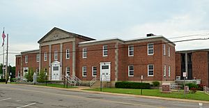
The Jefferson County Courthouse in Hillsboro
|
||
|
||

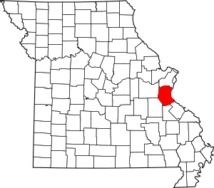
Location within the U.S. state of Missouri
|
||
 Missouri's location within the U.S. |
||
| Country | ||
| State | ||
| Founded | 1818 | |
| Named for | Thomas Jefferson | |
| Seat | Hillsboro | |
| Largest city | Arnold | |
| Area | ||
| • Total | 664 sq mi (1,720 km2) | |
| • Land | 657 sq mi (1,700 km2) | |
| • Water | 7.7 sq mi (20 km2) 1.2% | |
| Population
(2020)
|
||
| • Total | 226,739 |
|
| Time zone | UTC−6 (Central) | |
| • Summer (DST) | UTC−5 (CDT) | |
| Congressional districts | 2nd, 3rd, 8th | |
Jefferson County is a county located in the eastern part of Missouri, a state in the United States. It is close to the big city of St. Louis. In 2020, about 226,739 people lived here. This makes it the sixth-largest county in Missouri by population.
The main town, or county seat, where the county government is located, is Hillsboro. Jefferson County was created in 1818. It was named after Thomas Jefferson, who was a former President of the United States.
Contents
Exploring Jefferson County
Where is Jefferson County?
Jefferson County covers an area of about 664 square miles (1,720 square kilometers). Most of this area is land, with a small part being water. The eastern side of the county borders the famous Mississippi River.
Neighboring Counties
Jefferson County shares its borders with several other counties:
- St. Louis County (to the north)
- Monroe County, Illinois (to the east)
- Ste. Genevieve County (to the southeast)
- St. Francois County (to the south)
- Washington County (to the southwest)
- Franklin County (to the west)
Main Roads
Many important highways run through Jefferson County, making it easy to travel around. These include:
 Interstate 55
 U.S. Route 61
 U.S. Route 67
 Route 21
 Route 30
 Route 109
 Route 110
 Route 141
 Route 231
Protected Nature Areas
Part of the Middle Mississippi River National Wildlife Refuge is located in Jefferson County. This area helps protect wildlife and their natural homes.
People of Jefferson County
| Historical population | |||
|---|---|---|---|
| Census | Pop. | %± | |
| 1820 | 1,835 | — | |
| 1830 | 2,592 | 41.3% | |
| 1840 | 4,296 | 65.7% | |
| 1850 | 6,928 | 61.3% | |
| 1860 | 10,344 | 49.3% | |
| 1870 | 15,380 | 48.7% | |
| 1880 | 18,736 | 21.8% | |
| 1890 | 22,484 | 20.0% | |
| 1900 | 25,712 | 14.4% | |
| 1910 | 27,878 | 8.4% | |
| 1920 | 26,555 | −4.7% | |
| 1930 | 27,563 | 3.8% | |
| 1940 | 32,023 | 16.2% | |
| 1950 | 38,007 | 18.7% | |
| 1960 | 66,377 | 74.6% | |
| 1970 | 105,248 | 58.6% | |
| 1980 | 146,183 | 38.9% | |
| 1990 | 171,380 | 17.2% | |
| 2000 | 198,099 | 15.6% | |
| 2010 | 218,733 | 10.4% | |
| 2020 | 226,739 | 3.7% | |
| U.S. Decennial Census 1790-1960 1900-1990 1990-2000 2010-2019 |
|||
In 2020, the population of Jefferson County was 226,739 people. Most residents, about 90.4%, were White. About 1.0% were Black or African American, and 0.8% were Asian. About 2.4% of the population identified as Hispanic or Latino.
Education in Jefferson County
Jefferson County has many schools for students of all ages.
Public Schools
There are several public school districts serving the communities in Jefferson County:
- School District 47 in Crystal City
- Crystal City High School
- De Soto School District 73 in De Soto
- De Soto Jr. High School
- De Soto High School
- Dunklin R-V School District in Herculaneum
- Festus R-IV School District in Festus
- Festus Middle School
- Festus High School
- Fox C-6 School District in Arnold
- Grandview R-II School District in Hillsboro
- Grandview Middle School
- Grandview High School
- Hillsboro R-3 School District in Hillsboro
- Hillsboro Middle School
- Hillsboro Jr. High School
- Hillsboro High School
- Jefferson County R-VII School District in Festus
- Danby-Rush Tower Middle School
- Jefferson High School
- Northwest R-I School District in High Ridge
- Woodridge Middle School
- Valley Middle School
- Northwest High School
- Sunrise R-IX School District in De Soto
- Windsor C-1 School District in Imperial
Private Schools
Many private schools also offer education in the county, including:
- Christian Outreach School (Hillsboro)
- People's Christian Academy (Arnold)
- St. Pius X High School (Festus)
- Twin City Christian Academy (Festus)
- Good Shepherd Catholic School (Hillsboro)
- Holy Child Elementary & Middle School (Arnold)
- Manna Christian Academy (De Soto)
- Our Lady's Catholic School (Festus)
- Sacred Heart Catholic School (Festus)
- St. Anthony's Catholic School (High Ridge)
- St. Joseph's Catholic School (Imperial)
- St. Johns Lutheran School (Arnold)
- St. Johns School (Imperial)
- St. Rose of Lima Catholic School (De Soto)
College Education
For students seeking higher education, Jefferson College is located in Hillsboro. It is a public community college where students can earn a two-year degree.
Public Libraries
Jefferson County has several public libraries where you can find books, resources, and learn new things:
- Crystal City Public Library
- De Soto Public Library
- Festus Public Library
- Herculaneum Public Library
- Jefferson County Public Library
Parks and Recreation
Jefferson County offers various parks and recreational areas for outdoor activities and fun:
- Big River Saddle Club
- Brown's Ford
- Cedar Hill
- Fletcher House
- High Ridge Civic Center
- Rockford Beach
- Jefferson Winter Park
- Morse Mill
- Pleasant Valley
- Sunridge
- NW Jefferson County Sports Complex
Towns and Communities
Jefferson County is made up of many different cities, villages, and smaller communities.
Cities
- Arnold
- Byrnes Mill
- Crystal City
- De Soto
- Festus
- Herculaneum
- Hillsboro (county seat)
- Kimmswick
- Olympian Village
- Pevely
Villages
Townships
- Big River
- Central
- High Ridge
- Joachim
- Meramec
- Plattin
- Rock
- Valle
Census-designated places
These are areas that are like towns but are not officially incorporated as cities or villages.
- Barnhart
- Briarwood Estates
- Cedar Hill
- High Ridge
- Horine
- Imperial
- LaBarque Creek
- Murphy
- Raintree Plantation
- Summer Set
Other Unincorporated Communities
These are smaller communities that are not officially part of a city or village.
- Antonia
- Bailey
- Belews Creek
- Bushburg
- Byrnesville
- Danby
- Dittmer
- Donnell
- Fletcher
- Flucom
- Frumet
- Goldman
- Grubville
- Hematite
- House Springs
- Jarvis
- Knorpp
- Liguori
- Local
- Ludwig
- Mapaville
- Melzo
- Meramec Heights
- Morse Mill
- Munsons
- Oermann
- Old Mines
- Papin
- Plattin
- Regina
- Riverside
- Rush Tower
- Seckman
- Selma
- Sulphur Springs
- Valles Mines
- Victoria
- Vineland
- Ware
See also
 In Spanish: Condado de Jefferson (Misuri) para niños
 | Kyle Baker |
 | Joseph Yoakum |
 | Laura Wheeler Waring |
 | Henry Ossawa Tanner |


