Green Bay (Lake Michigan) facts for kids
Quick facts for kids Green Bay |
|
|---|---|

Green Bay
|
|
| Location | Brown County, Door County, Kewaunee County, Marinette County, Oconto County (Wisconsin), Delta County, Menominee County (Michigan) |
| Coordinates | 45°01′47″N 87°27′39″W / 45.02972°N 87.46083°W |
| Type | Bay |
| Surface elevation | 581 feet (177 m) |
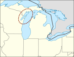
Green Bay is a large arm, or part, of Lake Michigan. It's located along the southern coast of Michigan's Upper Peninsula and the eastern coast of Wisconsin. A long piece of land called the Door Peninsula in Wisconsin, the Garden Peninsula in Michigan, and a chain of islands separate it from the rest of Lake Michigan. These landforms were created by something called the Niagara Escarpment.
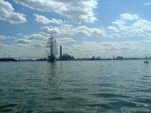
Green Bay is about 120 miles (193 km) long and 10 to 20 miles (16 to 32 km) wide. Its total area is 1,626 square miles (4,211 km²). At the southern end of the bay is the city of Green Bay, Wisconsin, where the Fox River flows into it. The Leo Frigo Memorial Bridge crosses where the Fox River meets the bay. Other important places along the bay include Sturgeon Bay and the Peshtigo River. Sturgeon Bay is a helpful shortcut for large ships to avoid sailing all the way around the Door Peninsula. Locally, people sometimes call it the Bay of Green Bay to make sure they mean the water, not the city.
The bay touches parts of five counties in Wisconsin: Brown, Door, Kewaunee, Marinette, and Oconto. It also touches two counties in Michigan: Delta and Menominee.
Contents
History of Green Bay

The area around Green Bay has a very long history. Near Oconto, you can find Copper Culture State Park. This park has ancient burial grounds from the Copper Culture Indians, dating back about 5,000 to 6,000 BC. It's thought to be one of the oldest cemeteries in Wisconsin and even the entire country. The Ho-Chunk people, a Native American tribe, believe they were created on the shores of Green Bay at a place called Red Banks.
European explorers arrived much later. A French Jesuit priest named Father Claude-Jean Allouez held the first Christian Mass in Oconto on December 3, 1669.
Naming the Bay
The French explorer Jean Nicolet first named the bay la baie des Puants, which means "the bay of the Stinks." This name appeared on many French maps in the 1600s and 1700s. Historians believe the French got this name from their Native American guides. The guides used a word for the natives living near Green Bay that meant "Stinkers."
Another explorer, Jacques Marquette, thought the name might come from the smell of the swamps when he explored the area in May 1673. His fellow explorer Louis Joliet and five French-Indian voyageurs were traveling to find the Mississippi River. They went up the Fox River, almost to its source. The French also called the bay Baie Verte, which means "Green Bay," and the English kept this name. In the Menominee language, the bay is called Pūcīhkit, which also means "bay that smells like something rotting."
Bay Features
Green Bay has some interesting natural features. You can find Ferromanganese nodules in the bay, which are small lumps of rock containing iron and manganese. A mineral called Todorokite is found inside these nodules.
There are also many reefs, which are areas of exposed rock, in the Porte des Mortes passage and within the bay itself. North of the Door Peninsula, warmer water from Green Bay flows into Lake Michigan on the surface. At the same time, colder lake water enters Green Bay deep underneath.
Environmental Concerns
Green Bay faces some environmental challenges, especially in its lower part. The Environmental Protection Agency (EPA) has identified it as an "Area of Concern." This means it's a geographic area in the Great Lakes basin that has serious environmental problems.
Pollution Sources
The Lower Green Bay Area of Concern was first named in 1987. It was affected by several types of pollution:
- Runoff from cities and farms.
- Wastewater from towns and factories.
- Damaged natural habitats.
- Heavy industry also played a big part in the bay becoming polluted.
These issues led to problems like cloudy water, too much sediment, low oxygen levels, frequent algal blooms (when algae grow out of control), and unhealthy fish, wildlife, and plant populations. The bay is also shallow, which makes it harder for it to clean itself.
Beneficial Use Impairments
To help fix these problems, experts look at "Beneficial Use Impairments" (BUIs). These are changes in the water that cause significant environmental damage. For an Area of Concern to be considered healthy again, all its designated BUIs must be removed.
Here are some of the problems identified for Green Bay:
- Limits on eating fish and wildlife.
- Fish and wildlife tasting bad.
- Fewer fish and wildlife.
- Fish having tumors or other problems.
- The bay looking bad.
- Limits on dredging (removing mud from the bottom).
- Loss of places for fish and wildlife to live.
- Birds or animals having problems with their bodies or having trouble reproducing.
- Too many nutrients from pollution.
- Limits on drinking the water, or the water tasting and smelling bad.
- Beaches closing.
- Fewer helpful microorganisms in the water.
Restoration Timeline
Since 1988, a lot of work has been done to clean up the Lower Green Bay. More than three-quarters of the recommended actions have been started or completed.
- 1988: The first plan for action is released.
- 1993: An update to the plan shows progress and sets new goals.
- 2003: A plan for environmental assessment and restoration is released.
- 2003-2008: Tests show that beaches are generally healthy, but more projects are needed.
- 2009: Wisconsin DNR sets goals for removing each of the BUIs.
- 2010-2011: New laws are passed to reduce pollution, like banning phosphorus in some household products and reducing farm runoff.
- 2011: An updated action plan describes key steps taken and future projects.
- 2012: The US Army Corps of Engineers starts the Cat Island restoration project, and a lot of polluted sediment is removed.
- 2013: A report is released on the status of the BUIs, and a judge rules that companies responsible for pollution must help with cleanup.
Cleanup Efforts
In 1999 and 2000, the EPA oversaw a cleanup project where about 80,000 cubic yards of polluted sediment were removed from the Fox River. This sediment contained a harmful chemical called PCBs.
Cleanup efforts in the Lower Green Bay continue. In 2019, it marked the 16th year of cleanup. Monitoring of fish, water, and PCB levels will continue even after the main cleanup is finished to ensure the bay stays healthy.
Images for kids
-
Although the lower and upper parts of the bay are separated by Chambers Island (upper right), the northeastern edge of the area of concern ends much lower into the bay at Long Tail Point (lower left). Taken by Landsat 8 on February 25, 2022.
See also
 In Spanish: Bahía de Green Bay para niños
 | Jackie Robinson |
 | Jack Johnson |
 | Althea Gibson |
 | Arthur Ashe |
 | Muhammad Ali |


