
Chambers Island facts for kids

Chambers Island from Fish Creek
|
|

Chambers Island
Location in Wisconsin
|
|
| Etymology | Talbot Chambers |
|---|---|
| Geography | |
| Location | Green Bay |
| Coordinates | 45°10′56″N 087°21′19″W / 45.18222°N 87.35528°W |
| Area | 10.04 km2 (3.88 sq mi)land area |
| Highest elevation | 600 ft (180 m), 55 ft above lake level (approx) |
| Administration | |
|
United States
|
|
| State | Wisconsin |
| County | Door |
| Town | Gibraltar |
Chambers Island is a large island in Green Bay, a part of Lake Michigan. It's about 7 miles (11 km) from the Door Peninsula in Wisconsin. The island is named after Col. Talbot Chambers.
Chambers Island covers about 2,834 acres (10.04 square kilometers). It is part of the Town of Gibraltar in Door County.
Contents
Exploring Chambers Island
Chambers Island has two lakes. The biggest is Mackaysee Lake, which covers about 348 acres (1.4 square kilometers). It's in the northeastern part of the island. West of Mackaysee Lake is a smaller lake called Mud Lake.
Islands within Islands
Did you know there are islands inside Mackaysee Lake? This means there are islands in a lake, which is on an island, which is in a much bigger lake (Green Bay)! These are sometimes called "third order recursive islands."
The Chambers Island Lighthouse
Since 1867, Chambers Island has been home to the Chambers Island lighthouse. This lighthouse helped guide ships for many years. It was turned off in 1961. Since 1976, the lighthouse has been part of the Chambers Island County Park. This park is about 40 acres (16 hectares) in size.
Island Features
The highest point on the island is about 55 feet (17 meters) above the lake. In the southeast, the island gets very narrow. This narrow strip of land is called Hanover Shoal. It stretches towards the Door Peninsula shoreline. The island has a few cabins, but not many people live there all year round.
Life on the Island
Most of Chambers Island is privately owned. This means it belongs to different people and companies. Landing on private areas without permission is not allowed. In 2000, no permanent residents were reported on the island.
Holy Name Retreat House
For over 60 years, the Roman Catholic Diocese of Green Bay had a special retreat house on Chambers Island. It was called the Holy Name Retreat House. This house was a place where thousands of people came each year to relax and reflect. It was open from May to September.
The retreat house closed in 2014. It became too expensive to run, and fewer people were visiting. Also, getting medical help to the isolated island was a concern.
Chambers Island Airport
The island also has its own airport! It's called Chambers Island Airport. It's a private airport with one gravel runway. The runway is about 1,200 feet (366 meters) long and 40 feet (12 meters) wide.
Power and Communication
There is no regular electricity grid on Chambers Island. People who live or stay there use their own generators. They also use solar panels or wind power to create electricity.
Cell phone service is available on the island. Cellcom has a tower on the island. In 2012, Cellcom added a wind turbine to help power their tower. This works along with solar panels to charge the batteries for the site.
Island Weather
|
||||||||||||||||||||||||||||||||||||||||||||||||||||||||||||||||||||||||||||||||||||||||||||||||||||||||||||||||||||||||||||||||||||||||||||||||||||||||||||||||||||||||||||||||||||||||||||||||
Gallery
-
Chambers Island across frozen Green Bay
-
Chambers Island and lighthouse
-
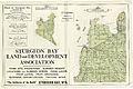
Map of northeastern coast of the Door peninsula with Chambers Island on the left.


Images for kids
-

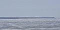
Hanover Shoal on July 27, 2020; the average lake level for July 2020 was 177.45 meters.
-
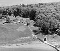
The public dock is at the far right and closer to the top
.png)
.png)
