
Door County, Wisconsin facts for kids
Quick facts for kids
Door County
|
|
|---|---|

Door County Government Center in Sturgeon Bay
|
|

Location within the U.S. state of Wisconsin
|
|
 Wisconsin's location within the U.S. |
|
| Country | |
| State | |
| Founded | 1851 |
| Named for | Porte des Morts |
| Seat | Sturgeon Bay |
| Largest city | Sturgeon Bay |
| Area | |
| • Total | 2,370 sq mi (6,100 km2) |
| • Land | 482 sq mi (1,250 km2) |
| • Water | 1,888 sq mi (4,890 km2) 80% |
| Population
(2020)
|
|
| • Total | 30,066 |
| • Estimate
(2023)
|
30,562 |
| • Density | 62.4/sq mi (24.1/km2) |
| Demonym(s) | Door Countyite |
| Time zone | UTC−6 (Central) |
| • Summer (DST) | UTC−5 (CDT) |
| Area code | 920 |
| Congressional district | 8th |
| Wisconsin county code 15 FIPS county code 55029 |
|
Door County is a special place in Wisconsin, located on the eastern side of the state. In 2020, about 30,000 people lived here. The main city and county seat is Sturgeon Bay.
It gets its name from a tricky water passage called "Death's Door" between the Door Peninsula and Washington Island. This area has many old shipwrecks. Native Americans and early French explorers knew about this dangerous spot. Door County was officially formed in 1851.
Many people call Door County the "Cape Cod of the Midwest." It is a very popular place for vacations in the Upper Midwest.
History of Door County
Early People and French Explorers
Door County's name comes from Porte des Morts ("Death's Door"). This is a passage between the tip of the Door Peninsula and Washington Island. The name "Death's Door" comes from old Native American stories. Early French explorers heard these tales.
One story tells of a battle between the Ho-Chunk and Pottawatomi tribes. It happened in the early 1600s. The Ho-Chunk tribe tried to take Washington Island but failed. This passage is also known for many shipwrecks.
Settlement and Growth
First Settlers and Communities

In the 1800s and 1900s, many people moved to Door County. These included pioneers, sailors, fishermen, loggers, and farmers. The first white settler was Increase Claflin. In 1851, Door County became separate from Brown County.
In 1853, a group called the Moravians started the town of Ephraim. An African-American community also formed on Washington Island in 1854. The first post office in the county opened on Washington Island in 1854.
Many Belgian families also settled in the southern part of the county. They built small roadside chapels. Some of these are still used today. They also brought traditions like the Kermiss harvest festival from Europe.
Big Fire of 1871
In 1871, a huge fire called the Peshtigo fire swept through the area. It burned the town of Williamsonville. Fifty-nine people died there. Today, this area is Tornado Memorial County Park. It is named after a fire whirl that happened during the fire. In total, 128 people in Door County died in the Peshtigo fire.
Early Days of Tourism

.jpg)
Even after train service reached Sturgeon Bay in 1894, many tourists still took steamships. They would travel from Menominee, Michigan across Green Bay to Door County. This was because the roads in the northern part of the county were very bad until the early 1920s.
Once better roads were built, cars and horse-drawn carriages became popular. They helped people travel between Sturgeon Bay and the northern peninsula. By 1909, about 1,000 tourists visited each year. This number grew to 1.9 million by 1995.
Recent Events
In 1913, the famous song The Old Rugged Cross was first sung in Sturgeon Bay. In 2004, Door County started a sister city relationship with Jingdezhen in China.
Geography of Door County
Door County is the largest county in Wisconsin by total area. It covers most of the Door Peninsula. The county has about 298 miles (480 km) of shoreline.
The Sturgeon Bay Shipping Canal was finished in 1881. This canal made the northern part of the peninsula an artificial island. The canal also seemed to help fish populations grow in nearby waters.
Climate and Weather
Door County has a humid continental climate. This means it has warm summers and cold, snowy winters. The nearby water helps keep the weather milder. This means late spring freezes are less likely and not as bad as in other areas.
Fun Things to Do and See
.jpg)
Today, most visitors come from big cities like Milwaukee, Chicago, and Minneapolis. Illinois residents are the largest group of visitors.
Parks and Natural Areas

Door County has six state parks:
- Newport State Park
- Peninsula State Park
- Potawatomi State Park
- Whitefish Dunes State Park
- Rock Island State Park
- Grand Traverse Island State Park
There are also State Wildlife and Fishery Areas. These places allow free public access. Plum Island and Green Bay National Wildlife Refuge are open to the public during certain times of the year.
Lakes and Rivers
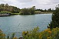
Besides Lake Michigan and Green Bay, Door County has 26 other lakes, ponds, or marshes. It also has 37 rivers, creeks, and springs. The deepest lakes are Mackaysee Lake (26 feet deep) and Krause Lake (24 feet deep). Both are on Chambers Island.
Amazing Animals
Unique Creatures
A special kind of eastern chipmunk called Tamias striatus doorsiensis lives only in Door County and a few nearby counties. In 1999, 24 water animals and 21 land animals in Door County were listed as "rare."
Birds
As of 2018, 166 different bird species have been seen living in Door County. This does not include birds just passing through.
Insects
Kangaroo Lake State Natural Area is home to the largest group of the endangered Hine's Emerald Dragonfly in the world. The Lake Huron locust lives on the sand dunes in Door County. It is not found anywhere else in Wisconsin.
Culture and History
Lighthouses and Historic Sites
Door County has many lighthouses and lights along its shorelines. There are 10 historic lighthouse structures that still help guide ships. Most of these were built in the 1800s. They are listed on the National Register of Historic Places. Some examples include:
- Baileys Harbor Range Lights
- Cana Island Lighthouse
- Chambers Island Lighthouse
- Eagle Bluff Lighthouse
- Pottawatomie Lighthouse
- Sturgeon Bay Canal Lighthouse
The tugboat John Purves in Sturgeon Bay is a museum ship. There are 72 historic places and areas in the county listed on the National Register of Historic Places.
Door County also has 214 known shipwrecks. Some of these are popular spots for wreck diving.

Door County has a strong Scandinavian heritage. You can see this at places like The Clearing Folk School and two stave churches. Al Johnson's Swedish Restaurant is famous for having goats on its grassy roof!
Many people enjoy a "fish boil" in Door County. While often linked to Scandinavian traditions, many different groups on the peninsula have a history of boiling fish. The way it's done here is similar to how Native Americans prepared fish.
Local Industry
In Sturgeon Bay, you can learn about local industries. You can take tours of the Bay Shipbuilding Company and other manufacturers. This is a type of industrial tourism.
Economy
Door County's economy mainly relies on "forestry-related tourism." In 2020, the county's total economic output was $1.39 billion. Manufacturing became the biggest industry that year.
Getting Around Door County
Land Travel
In 2021, Door County had about 1,270 miles (2,040 km) of roads.


![]() Wisconsin Highway 42 (WIS 42) and
Wisconsin Highway 42 (WIS 42) and ![]() Wisconsin Highway 57 (WIS 57) are the main highways. They split and then join again. WIS 42 on the western side usually has more traffic than WIS 57 on the eastern side.
Wisconsin Highway 57 (WIS 57) are the main highways. They split and then join again. WIS 42 on the western side usually has more traffic than WIS 57 on the eastern side.
The Door County Coastal Byway is a beautiful drive. It follows WIS 42 and WIS 57 north of Sturgeon Bay.
There are also five rustic roads in the county. These are quieter, scenic roads.
Trails for Fun
The Ahnapee State Trail connects Sturgeon Bay to Kewaunee. You can use it for snowmobiling in winter if the trails are ready. The Ice Age Trail also goes through Sturgeon Bay and ends at Potawatomi State Park. Some state parks have mountain bike trails.
WIS 42 and WIS 57 are part of the Lake Michigan Circle Tour. This is a route for exploring the areas around Lake Michigan. Egg Harbor has a free public bicycle-sharing system for visitors during the day.
Bridges in Sturgeon Bay
There are three main bridges that cross Sturgeon Bay:
- The Sturgeon Bay Bridge (also called Michigan Street Bridge)
- The Oregon Street Bridge
- The Bayview Bridge
Ground Transportation Services
A private shuttle service runs daily between Green Bay–Austin Straubel International Airport and Sturgeon Bay. For longer trips, the nearest bus stop with regular service is in Green Bay. Within Door County, there are private and public transportation services, but they don't have regular schedules for everyone.
Air Travel
Door County has eleven airports. Some are private, and some are for public use.
- Door County Cherryland Airport (KSUE) is a public airport.
- Ephraim–Gibraltar Airport (3D2) is a public airport.
- Washington Island Airport (2P2) is a public airport.
- Door County Memorial Hospital has a heliport for air ambulance services.

Water Travel
Ferries
- Washington Island can be reached by two ferry routes from the Door Peninsula. One ferry carries cars and people from Northport Pier. It takes about 30 minutes. Another ferry carries only passengers from Gills Rock. It takes about 20 minutes.
- Rock Island State Park can be reached by the passenger ferry Karfi from Washington Island. In winter, you might be able to reach Rock Island by snowmobile or by walking.
- There is no regular ferry to Chambers Island. However, boat operators can take people to the island from Fish Creek if you call them.
Boat Ramps and Marinas
There are 30 public places where you can launch a boat in Door County. The Lake Michigan State Water Trail follows most of the county's shorelines.
Communities in Door County

Cities
- Sturgeon Bay (This is the main city and county seat.)
Villages
Towns
Unincorporated Communities
These are smaller communities that are not officially cities or villages.
Census-designated places
Former Communities
Some communities have changed over time:
- Sawyer and Stevens Hill were absorbed into Sturgeon Bay.
- Rock Island (settlement), Newport (community), and Williamsonville are now state or county parks.
Neighboring Counties
By Land
- Kewaunee County - to the south
Across Green Bay
- Brown County - to the southwest
- Oconto County - to the west
- Marinette County - to the northwest
- Menominee County, Michigan - to the northwest
Across the Rock Island Passage
- Delta County, Michigan - to the north
Across Lake Michigan
- Leelanau County, Michigan - to the northeast and east
- Benzie County, Michigan - to the southeast
Famous People from Door County
- Robert C. Bassett (1911–2000), U.S. presidential advisor
- Norbert Blei (1935–2013), writer
- Gene Brabender (1941–1996), baseball player
- Jessie Kalmbach Chase (1879–1970), painter
- Hans Christian (born 1960), musician
- Eddie Cochems (1877–1953), known as the "father of the forward pass" in football
- Erik Cordier (born 1986), baseball player
- Katherine Whitney Curtis (1897–1980), created synchronized swimming
- A. J. Dillon (born 1998), Green Bay Packers football player
- Mary Maples Dunn (1931–2017), historian
- Phoebe Erickson (1907–2006), children's book author and illustrator
- Jim Flanigan (born 1971), football player
- Lou Goss (born 1987), racecar driver
- Chris Greisen (born 1976), football player
- Nick Greisen (born 1979), football player
- Stuart Hagmann (born 1942), film and television director
- Arthur G. Hansen (1925–2010), engineer and university president
- Hjalmar Holand (1872–1963), historian
- Jens Jensen (1860–1951), landscape architect
- Al Johnson (born 1979), football player
- Ben Johnson (born 1980), football player
- Bill Jorgenson (1930 – 2007), bluegrass musician
- Al C. Kalmbach (1910–1981), publisher
- Henry Killilea (1863–1929), helped start the American League in baseball
- Curly Lambeau (1898–1965), famous football player and coach
- James Larsin (b. 1855), saved seven people from drowning
- Doug Larson (1926–2017), newspaper writer
- Lester Leitl (1899–1980), football player and coach
- Pat MacDonald (born 1952), musician
- Amy McKenzie (born 1959), producer/director
- Edward S. Minor (1840–1924), U.S. Representative
- Conrad P. Olson (1882–1952), Oregon Supreme Court justice
- Sigurd F. Olson (1899–1982), wilderness guide
- Charles L. Peterson (1927–2022), painter
- Casey Rabach (born 1977), football player
- David M. Raup (1933–2015), paleontologist
- Hugh M. Raup (1901–1995), ecologist
- Dennis A. Reed (born 1822), Wisconsin State Representative
- Charles Reynolds (1839–1914), Wisconsin State Representative
- Thomas Reynolds (1840–1919), Wisconsin State Representative
- Jack Ritchie (1922–1983), writer of detective fiction
- Hallie H. Rowe (1896–1992), sheriff and Wisconsin State Assemblyman
- Paul J. Schlise (born 1966), U.S. Navy admiral
- John Shinners (born 1947), football player
- Paul Sills (1927–2008), director and improvisation teacher
- Allen Thiele (1940–2017), Coast Guard officer
- Chester Thordarson (1867–1945), inventor
- Emma Toft (1891–1982), resort owner
- Madeline Tourtelot (1915–2002), artist
- James Valcq (born 1963), writer of musicals
- Thorstein Veblen (1857–1929), economist
- Richard Warch (1939–2013), president of Lawrence University
- Lloyd Wasserbach (1921–1949), football player
- Charles Mitchell Whiteside (1854–1924), helped merge Sawyer and Sturgeon Bay
- Randy Wright (born 1961), Green Bay Packers football player
- Albert Zahn (1894–1953), folk artist known as the Birdman
Images for kids
-
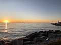
Sunset, Sister Bay
-
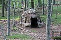
Wigwam display at Whitefish Dunes State Park
-
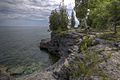
Cave Point County Park
-
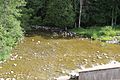
The Ahnapee River below the dam at Forestville
-
Sturgeon Bay Shipping Canal


See also
 In Spanish: Condado de Door para niños
