
Door Peninsula facts for kids
Quick facts for kids
Designations
|
|
| Official name: Door Peninsula Coastal Wetlands | |
| Criteria: | Door County § Wetlands |
|---|---|
| Designated: | 10 June 2014 |
| Reference #: | 2218 |

The Door Peninsula is a piece of land in eastern Wisconsin. It separates the southern part of Green Bay from Lake Michigan. This peninsula includes parts of Brown and Kewaunee counties, and all of Door County. It is also the western edge of the Niagara Escarpment, a long cliff-like ridge.
The Door Peninsula is famous for its cherry and apple orchards. It's a very popular place for tourists to visit. In 1881, the Sturgeon Bay Ship Canal was finished. This canal cut through the peninsula, making its northern half into an island.
You can see limestone cliffs from the Niagara Escarpment on both sides of the peninsula. They are much bigger on the Green Bay side, like at the Bayshore Blufflands. Over time, sand dunes have formed most of the shoreline, especially on the east side. Plants growing along the shore show how different plant communities grow and change over time. The middle of the peninsula is mostly flat farmland. North of the peninsula's tip are several islands. The biggest one is Washington Island. This underwater ridge continues north, becoming the Garden Peninsula in Upper Michigan.
Contents
History of the Door Peninsula
Ancient People of the Peninsula

Archaeologists have found proof that different Native American groups lived on the Door Peninsula and its islands long ago.
Very old tools from Paleo-Indians were found at the Cardy Site. These included special spear points called Gainey points. Most of the materials found there by 2003 were made from a type of rock called Moline chert, which isn't found in Wisconsin. By 2007, seven Clovis points, another type of ancient spear point, had been found in the county. Some ancient tools from western Wisconsin seem to have been made here and carried across the state.
At Nicolet Bay Beach, artifacts from an ancient village date back to about 400 BC. Different cultures lived at this site until about 1300 AD. In 246 BC, a dog was buried at a Native American burial site on Washington Island.
Jean Nicolet's Journey
In 1634, French explorer Jean Nicolet arrived in this area. He was looking for a water route through North America to Asia. Two places on the peninsula claim to be where he landed: Horseshoe Island and Red Banks. Red Banks is about 7 miles north of what is now Green Bay.
Nicolet is famous in Wisconsin stories for thinking the Ho-Chunk Indians were Asians. He celebrated, believing he had reached the Far East. He had heard that the people here were called "Winnebago," meaning "people from the stinking water." He thought this meant they were from or near the Pacific Ocean, which has salty air. He believed they would lead him to China.
How the Peninsula Got Its Name
The name of the peninsula and the county comes from a dangerous water passage. This passage is between the Door Peninsula and Washington Island. It connects Green Bay to Lake Michigan. This small strait is now full of shipwrecks. Native Americans named it, and the French translated it as Porte des Morts, which means "Death's Door" in English.
Potawatomi and Menominee People
Before and during the 1800s, various Native American tribes lived on the Door Peninsula and nearby islands. French explorers first met these tribes in the 1600s. In 1634, the Jean Nicolet group landed at Rock Island. This was the first time Europeans visited what is now Wisconsin.
In 1665, Pierre-Esprit Radisson and Médard des Groseilliers spent a winter with the Potawatomi people. In 1669, Claude-Jean Allouez also stayed with the Potawatomi. He mentioned an area called "la Portage des Eturgeons." Later, in 1673, Jacques Marquette and Louis Jolliet explored the area for about three months. In 1679, a group led by La Salle bought food from a Potawatomi village. This village was in what is now Robert La Salle County Park.
During the 1670s, Louis André helped about 500 Native Americans at Rowleys Bay. He put up a cross there, which stood until about 1870. Around 1690, Nicolas Perrot visited the Potawatomi on Washington Island. In 1720, Pierre François Xavier de Charlevoix visited the area with eight experienced voyageurs.
Archaeologists found six Jesuit rings and turquoise glass trade beads on Rock Island. These were left by Potawatomi, Odawa, and Huron-Peton-Odawa Native Americans in the 1600s and 1700s. The remains of four Native American buildings were found at the Rock Island II Site during digs from 1969 to 1973.
By 1763, when French rule ended, many Potawatomi had started moving to the Detroit area. This left fewer large communities in Wisconsin. Later, some Potawatomi moved back to northern Wisconsin from Michigan. However, some Potawatomi then left northern Wisconsin for northern Indiana and central Illinois.
In 1815, Captain Talbot Chambers was wrongly reported to have died fighting Native Americans on Chambers Island. The island was named after him in 1816. In 1833, Odawa people on Detroit Island were baptized during a visit by Frederic Baraga. In 1835, one of two fishermen living on Detroit Island was killed, along with some Native Americans. The other fisherman was saved by a passing boat. From the 1840s to the 1880s, the Clark brothers ran a fishing camp at Whitefish Bay. This camp employed 30 to 40 fishermen. Also, 200–300 Potawatomi people extracted fish oil from the fish waste at the camp.

The Menominee tribe gave up their claim to the Door Peninsula to the United States in the 1836 Treaty of the Cedars. This happened after years of talks with the Ho-Chunk and the U.S. government. The goal was to make room for new groups like the Oneida, Stockbridge-Munsee, and Brothertown peoples, who had been moved from New York. Because of this treaty, settlers could buy land. However, many fishermen still chose to live as squatters without buying land. At the same time, the Potawatomi, who were more spread out, lost their land without being paid.
Some Potawatomi moved to Canada for several reasons. One reason was that Native Americans already in Canada invited them to join. Another was that the British wanted to encourage as many Native Americans as possible to move from the United States. Even before their final move, many Potawatomi had traveled to Canada to get payments for helping the British during the War of 1812. They also wanted to show their loyalty. Another reason was to avoid the harsh rules of the 1833 Treaty of Chicago. This treaty paid Wisconsin Potawatomi less than those from the Chicago area. The U.S. government said that any Potawatomi who did not move west as the treaty said would not be paid for their land. Also, some preferred the climate of the Great Lakes area over the Plains. Starting in 1837, the American government often forced Native Americans to move instead of letting them choose. Moving to Canada became a way to stay in the Great Lakes area without being forced to move far away.
Potawatomi Chief Simon Kahquados went to Washington, D.C., many times to try and get the land back. In 1906, Congress passed a law to count all Potawatomi who used to live in Wisconsin and Michigan. This was the first step toward paying them back. The 1907 "Wooster" roll, named after the clerk who made it, listed 457 Potawatomi in Wisconsin and Michigan and 1423 in Ontario. Instead of returning the land, they received a small monthly payment. Even though Kahquados didn't get the land back, he helped more people learn about Potawatomi history. In 1931, 15,000 people attended his burial in Peninsula State Park.
Changes to County Borders
.jpg)
In 1818, Michilimackinac and Brown counties were created. Their border went through the Door Peninsula at Sturgeon Bay. The southern part of what is now Door County was in Brown County. The northern part was in Michilimackinac County.

In 1836, the northern part of Door County was moved from Michilimackinac County to Brown County. This was part of a larger change to county borders.

When Door County was created from Brown County in 1851, it included what is now Kewaunee County. Kewaunee County then separated from Door County in 1852.
In 1923, Michigan claimed ownership of Plum, Detroit, Washington, and Rock islands in Door County. However, Michigan did not take control of them. In 1926, the Supreme Court rejected Michigan's claim. The court made a mistake and seemed to give islands north of Rock Island in Delta County (Michigan) to Wisconsin. Door County never took control of these Michigan islands. The mistake was fixed again by the Supreme Court in 1936. This decision left the islands in Door and Delta counties as they were before the legal case.
The northern part of the peninsula, which relies more on tourism, became more like the professional and business people who visited. The southern part, which relies more on farming, stayed more rural. Because of differences in money, culture, and people between the north and south of Door County, there are sometimes arguments about where to draw the line between Door and Kewaunee counties.
Geography of the Peninsula
High Points and Landmarks
Door County's High Spots
Buildings on High Points

- A tower on Brussels Hill is owned by the Wisconsin Public Service Corporation.
- Boyer Bluff Lighthouse is an 80-foot (24-meter) tall tower on Washington Island's Boyer Bluff. This spot is 722 feet (220 meters) high.
- "The Mountain" at Mountain Park on Washington Island is the highest point on the island. It has a lookout tower.
- Eagle Bluff Lighthouse is on Eagle Bluff, which is 597 feet (182 meters) high.
- Pottawatomie Light is on Pottawatomie Point on Rock Island.
- A wind turbine project was finished in 1999. At that time, the 30.5-acre (12.3-hectare) Rosiere Wind Farm was the largest in the eastern United States.
Other High Points
- Deathdoor Bluff is 728 feet (222 meters) high.
- Ellison Bluff is 587 feet (179 meters) high.
- Mount Lowe is 728 feet (222 meters) high.
- Sister Bluffs are 581 feet (177 meters) high.
- Svens Bluff is 633 feet (193 meters) high.
- Table Bluff is 623 feet (190 meters) high.
- Some other high points do not have names yet.
Kewaunee County's High Spots
- Cherneyville Hill is 1,014 feet (309 meters) high.
- Dhuey Hill is 912 feet (278 meters) high.
- Montpelier Hills are 951 feet (290 meters) high.
Caves and Sinkholes
| Sea Caves of the Door Peninsula and Rock Island |
|||
   |
A deep pit cave was found at the bottom of Brussels Hill. It holds the bones of animals from today and from long ago. This is the deepest known pit cave and the fourth-longest cave of any kind in Wisconsin. It was found by digging into three sinkholes. Hundreds of sinkholes have been found and mapped in Door County. Most sinkholes here form slowly as material sinks into the ground, rather than a sudden collapse. Some are filled in by farming or nature, but then sink again from melting snow or heavy rain.
Many caves are found in the escarpment. One, Horseshoe Bay Cave, is Wisconsin's second-longest. It has an underground waterfall that is 45 feet high. Horseshoe Bay Cave is home to rare small creatures without backbones. Several tiny caves at Peninsula State Park are open for people to visit. Eagle Cave is bigger but is located partway up the escarpment.
Only one cave not formed by karst or lake erosion has been found in Door County. It is in the basement of a nursing home in Sturgeon Bay.
Waters of the Peninsula
Sturgeon Bay and Little Sturgeon are special places for nature because they have many different kinds of fish.
North of the peninsula, warm water from Green Bay flows into Lake Michigan on the surface. At the same time, cold lake water flows into Green Bay deep below. This is a main reason why oxygen levels in the bay are often too low for fish.
Salmon Fishing
Starting in 1964, first coho and then Chinook salmon were put into Lake Michigan. New young Chinook salmon are put into the lake in the spring. Their eggs and milt (sperm) are collected from late September to early November. This mainly happens at the Strawberry Creek Chinook Facility in southern Door County. The facility is a popular place for visitors during these times.
Recently, there has been worry that there won't be enough alewife fish for the salmon to eat. This is a concern because the Chinook salmon population has already dropped a lot in Lake Huron.
Tourists love to catch Chinook salmon on guided fishing trips. Several state record salmon have been caught in Door County waters on the Lake Michigan side. In 1994, the state record Chinook salmon was caught. It weighed 44 pounds, 15 ounces, and was 47.5 inches long. In 2016, the state record for a "pinook" (a mix of pink and Chinook salmon) was set. It weighed 9 pounds, 1.6 ounces, and was 27.87 inches long. In 2018, Kewaunee County was first in the state with 26,557 Chinook salmon caught. Door County was second with 14,268 fish caught.
| Commercial and Recreational Fishing | |||
      |
Fish Spawning Areas
Reefs and Shoals in Door County Waters
These are underwater rocky areas or shallow spots where fish often lay their eggs:
- Dunlap Reef
- Fisherman Shoal
- Four Foot Shoal
- Hanover Shoal
- Horseshoe Reefs
- Larsons Reef
- Middle Shoal
- Monument Shoal
- Nine Foot Shoal
- Outer Shoal
- Sherwood Point Shoal
- Sister Shoals
- Waverly Shoal
Other Fishing
Walleye fish found in the Sturgeon Bay and Little Sturgeon area had much more PCBs (harmful chemicals) than walleye from the western side of Green Bay. This matches what we know about how PCBs spread from factories in the Fox River Valley.
Round gobies are an invasive fish that eat mussels off the rocky shoreline. In 2014, the state speargun record for the invasive round goby was caught in Door County waters. It weighed 5.0 ounces and was 8.25 inches long.
Lake whitefish and yellow perch are caught by commercial fishermen. Lake whitefish are also caught by ice fishing. Studies have shown that whitefish travel from Big Bay de Noc, where there is less food, to the rich waters off the peninsula.
Old remains of sturgeon, catfish, sucker, smallmouth bass, white bass, walleye, and drum fish were found near North Bay in the 1960s. These were left by Native Americans.
Surfing and Windsurfing
The Lake Michigan shoreline is used for lake surfing. One guide book says the shore off Cave Point County Park is the best surfing spot. Another fun water sport here is windsurfing.
Climate of the Peninsula
|
||||||||||||||||||||||||||||||||||||||||||||||||||||||||||||||||||||||||||||||||||||||||||||||||
Lake Breeze Effect
On hot summer days, cool lake breezes start around noon. They get stronger by mid-afternoon. You can feel this effect right at the shoreline and about a mile or so inland. Even though lake breezes can go much further inland, they warm up quickly after moving over land. After just a mile of travel inland, they might be almost as warm as the air they are pushing away. When a lake breeze hits a curved shoreline, like at Sister Bay, the breeze becomes stronger. The curve of the shore guides the breezes from different sides of the bay, making them meet in the middle.
Rare Snails of Door County
From 1996 to 2001, scientists found 69 different kinds of snails in Door County. This was the most out of 22 counties studied. Most of these snails were found on rocky areas. Brown County was second with 62 species. Kewaunee County had 48 species, ranking eighth. Slugs were found in all three counties.
Peninsula State Park is home to the most northern group of Strobilops aenea snails known. The snail species Vertigo hubrichti and Vertigo morsei are only found in the upper Midwest. These two species were found most often along the Door and Garden Peninsulas. Door County also has several unusual species from the Oxychilus group. These snails are not native and came from Europe. One was found near a vacation home and might have been brought in with garden plants.
Within Door County, places like Brussels Hill, North Kangaroo Lake, Rock Island, and the escarpment with its cool algific habitat support groups of rare snails. Out of 63 places in Door County where snails were found, the most species (28) were on a cliff in Rock Island.
Images for kids
-
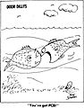
A comic drawn for the Door County Advocate in 1977 showing a fish with PCBs.

