
Sturgeon Bay, Wisconsin facts for kids
Quick facts for kids
Sturgeon Bay, Wisconsin
|
|
|---|---|

Downtown Sturgeon Bay
|
|
| Nickname(s):
Shipbuilding Capital of the Midwest
|
|

Location of Sturgeon Bay in Door County, Wisconsin.
|
|
| Country | |
| State | |
| County | Door |
| Area | |
| • Total | 11.49 sq mi (29.77 km2) |
| • Land | 9.83 sq mi (25.46 km2) |
| • Water | 1.66 sq mi (4.31 km2) |
| Population
(2020)
|
|
| • Total | 9,646 |
| • Density | 908.85/sq mi (350.92/km2) |
| Time zone | UTC−6 (Central (CST)) |
| • Summer (DST) | UTC−5 (CDT) |
| Zip Code |
54235
|
| Area code(s) | 920 |
| FIPS code | 55-77875 |
| Website | www.sturgeonbaywi.org |
Sturgeon Bay is a city in Door County, Wisconsin, United States. It is also the county seat, which means it's where the local government offices are. In 2020, about 9,646 people lived there. The city is named after the nearby Sturgeon Bay body of water. It's the biggest city on the Door Peninsula, which is a very popular place for vacations in the Upper Midwest.
Contents
History of Sturgeon Bay
The land where Sturgeon Bay is now was first home to the Ho-Chunk and Menominee Native American tribes. The Menominee people called the area Namāēw-Wīhkit, which means "bay of the sturgeon." They gave this land to the United States in a treaty in 1831. After that, people from other places started to settle there.
The community was first called Graham in 1855. Then, in 1857, it was named Ottumba by the state government. But the name went back to Graham. In 1860, people asked to change the name to Sturgeon Bay, after the bay itself. A group of volunteer firefighters started in 1869. In 1874, Sturgeon Bay officially became a village. It became a city in 1883, and that's when the police department began. In 1891, a politician named Charles Mitchell Whiteside helped combine the nearby community of Sawyer with Sturgeon Bay.
The city is famous for the Sturgeon Bay Bridge on Michigan Street. When it opened in 1931, it was the second bridge across the bay. It used to be part of a main highway route.
During World War II, Sturgeon Bay helped with war production. In 1943, many streets got new names. You can still see the old street names stenciled on some older sidewalks!
Geography and Climate
Sturgeon Bay is located at 44°49′56″N 87°22′19″W / 44.83222°N 87.37194°W. The city covers about 11.66 square miles (30.20 square kilometers). Most of this area is land, but about 1.84 square miles (4.77 square kilometers) is water.
Sturgeon Bay has a humid continental climate. This means it experiences all four seasons: warm summers, cold winters, and mild springs and autumns.
| Climate data for Sturgeon Bay, Wisconsin, 1991–2020 normals, extremes 1905–present | |||||||||||||
|---|---|---|---|---|---|---|---|---|---|---|---|---|---|
| Month | Jan | Feb | Mar | Apr | May | Jun | Jul | Aug | Sep | Oct | Nov | Dec | Year |
| Record high °F (°C) | 55 (13) |
58 (14) |
76 (24) |
85 (29) |
91 (33) |
100 (38) |
105 (41) |
102 (39) |
96 (36) |
86 (30) |
74 (23) |
60 (16) |
105 (41) |
| Mean maximum °F (°C) | 42.2 (5.7) |
45.0 (7.2) |
58.4 (14.7) |
70.6 (21.4) |
80.3 (26.8) |
87.3 (30.7) |
89.3 (31.8) |
88.3 (31.3) |
83.9 (28.8) |
74.6 (23.7) |
59.2 (15.1) |
46.7 (8.2) |
91.3 (32.9) |
| Mean daily maximum °F (°C) | 25.2 (−3.8) |
28.1 (−2.2) |
37.9 (3.3) |
50.1 (10.1) |
62.4 (16.9) |
72.6 (22.6) |
78.0 (25.6) |
76.8 (24.9) |
69.4 (20.8) |
55.9 (13.3) |
42.4 (5.8) |
31.1 (−0.5) |
52.5 (11.4) |
| Daily mean °F (°C) | 17.8 (−7.9) |
20.0 (−6.7) |
29.6 (−1.3) |
41.0 (5.0) |
52.5 (11.4) |
62.8 (17.1) |
68.4 (20.2) |
67.5 (19.7) |
59.9 (15.5) |
47.7 (8.7) |
35.6 (2.0) |
24.8 (−4.0) |
44.0 (6.6) |
| Mean daily minimum °F (°C) | 10.4 (−12.0) |
11.9 (−11.2) |
21.3 (−5.9) |
32.0 (0.0) |
42.5 (5.8) |
52.9 (11.6) |
58.8 (14.9) |
58.2 (14.6) |
50.7 (10.4) |
39.4 (4.1) |
28.9 (−1.7) |
18.5 (−7.5) |
35.5 (1.9) |
| Mean minimum °F (°C) | −7.9 (−22.2) |
−6.4 (−21.3) |
1.9 (−16.7) |
20.3 (−6.5) |
30.8 (−0.7) |
40.2 (4.6) |
47.7 (8.7) |
46.6 (8.1) |
37.4 (3.0) |
28.1 (−2.2) |
15.8 (−9.0) |
1.2 (−17.1) |
−11.3 (−24.1) |
| Record low °F (°C) | −29 (−34) |
−29 (−34) |
−23 (−31) |
2 (−17) |
20 (−7) |
29 (−2) |
36 (2) |
32 (0) |
26 (−3) |
12 (−11) |
−6 (−21) |
−22 (−30) |
−29 (−34) |
| Average precipitation inches (mm) | 1.71 (43) |
1.34 (34) |
1.90 (48) |
3.07 (78) |
3.32 (84) |
4.12 (105) |
3.57 (91) |
3.32 (84) |
3.10 (79) |
3.24 (82) |
2.20 (56) |
1.97 (50) |
32.86 (834) |
| Average snowfall inches (cm) | 15.6 (40) |
12.9 (33) |
8.6 (22) |
4.0 (10) |
0.0 (0.0) |
0.0 (0.0) |
0.0 (0.0) |
0.0 (0.0) |
0.0 (0.0) |
0.2 (0.51) |
2.4 (6.1) |
13.7 (35) |
57.4 (146.61) |
| Average precipitation days (≥ 0.01 in) | 11.0 | 8.3 | 8.6 | 10.3 | 12.3 | 11.0 | 11.2 | 9.6 | 10.1 | 11.3 | 9.5 | 10.4 | 123.6 |
| Average snowy days (≥ 0.1 in) | 7.3 | 6.0 | 4.0 | 1.7 | 0.0 | 0.0 | 0.0 | 0.0 | 0.0 | 0.1 | 1.7 | 5.8 | 26.6 |
| Source 1: NOAA | |||||||||||||
| Source 2: National Weather Service | |||||||||||||
People of Sturgeon Bay
| Historical population | |||
|---|---|---|---|
| Census | Pop. | %± | |
| 1880 | 1,199 | — | |
| 1890 | 2,195 | 83.1% | |
| 1900 | 3,372 | 53.6% | |
| 1910 | 4,262 | 26.4% | |
| 1920 | 4,553 | 6.8% | |
| 1930 | 4,983 | 9.4% | |
| 1940 | 5,439 | 9.2% | |
| 1950 | 7,054 | 29.7% | |
| 1960 | 7,353 | 4.2% | |
| 1970 | 6,776 | −7.8% | |
| 1980 | 8,847 | 30.6% | |
| 1990 | 9,176 | 3.7% | |
| 2000 | 9,437 | 2.8% | |
| 2010 | 9,144 | −3.1% | |
| 2020 | 9,646 | 5.5% | |
| U.S. Decennial Census | |||
In 2010, there were 9,144 people living in Sturgeon Bay. There were 4,288 households. Most people (95.1%) were White. About 2.7% of the population was Hispanic or Latino.
The average age of people in Sturgeon Bay was 45.2 years. About 19.8% of residents were under 18 years old. Also, 19.2% were 65 years or older. Slightly more than half of the residents (51.9%) were female.
Fun and Recreation
Sturgeon Bay has a movie theater called Sturgeon Bay Cinema 6. There's also a professional theater, the Third Avenue Playhouse. Each year, the city hosts the Steel Bridge Songfest. This event brings in famous musicians and songwriters to perform. Some past performers include Jackson Browne and Jane Wiedlin from The Go-Go's.
The city has 20 parks, covering over 121 acres. Sunset Park is the largest, at 44 acres. The county also has fairgrounds and maintains part of the Ahnapee State Trail. This trail goes into the city limits for 2.5 miles. The Ice Age Trail also passes through the city for 5 miles. It ends at Potawatomi State Park.
Schools and Learning

Students in Sturgeon Bay attend Sturgeon Bay High School. There is also a campus of Northeast Wisconsin Technical College for older students. For younger kids, there are two elementary schools: Sawyer and Sunrise. T.J. Walker Middle School is connected to the high school. The sports teams for Sturgeon Bay Schools are called the Clippers, named after a type of boat. St. Peter's Lutheran School is a private school for students from pre-kindergarten to 8th grade. Three other former schools have joined to form Saint John Bosco school.
Media and News
Sturgeon Bay used to have a newspaper called the Door County Advocate. It is now part of the Green Bay Press-Gazette. There are also many radio stations in the area. No television stations are based in Sturgeon Bay. However, some Green Bay TV stations have cameras there to show the weather.
Getting Around Sturgeon Bay

Highways
 WIS 42 goes north to towns like Egg Harbor and Sister Bay. South, it connects to Algoma and Manitowoc, where you can get on I-43.
 WIS 57 goes south to Green Bay. North, it connects to Baileys Harbor.
- CTH-S is another local highway.
There are several important bridges in the city. These include the Michigan Street Bridge (built 1929-31), the Bay View Bridge (built 1976-78), and the Oregon Street Bridge (built 2006-08).
Water Travel
Sturgeon Bay has a medium-sized port. Very large ships, up to 1000 feet long, can visit the port. There is a big shipbuilding and repair facility here. The Coast Guard Station Sturgeon Bay is also located at the port. Most of the boats that use the port are pleasure boats. Cruise boats can also dock at Graham Park.
Airport
Sturgeon Bay has its own airport, called Door County Cherryland Airport (SUE/KSUE). It is located near Wisconsin Highway 42 and 57.
Famous People from Sturgeon Bay
- Gideon Winans Allen, Wisconsin state representative
- Robert C. Bassett, U.S. presidential advisor
- Eddie Cochems (1877-1953), known as the "father of the forward pass" in football
- Frank N. Graass, Wisconsin state representative
- Chris Greisen, a football quarterback
- Nick Greisen, a football linebacker
- Stuart Hagmann, a film and television director
- Bernard Hahn, Wisconsin state representative
- Arthur G. Hansen (1925-2010), an engineer and former university president
- Joseph Harris, Wisconsin state senator
- Lawrence Johnson, Wisconsin state representative
- Al C. Kalmbach, who started Kalmbach Publishing
- Doug Larson, a newspaper writer
- Pat MacDonald, a musician from the band Timbuk 3
- Edward S. Minor, U.S. representative
- Conrad P. Olson, an Oregon Supreme Court justice
- Henry J. Overbeck, Wisconsin state representative
- Casey Rabach, a football center
- Dennis A. Reed, Wisconsin state representative
- Marian E. Rottman (1882–1955), a nursing educator
- Hallie H. Rowe, Wisconsin state representative
- Marjorie Rusche, a composer
- Paul J. Schlise, a U.S. Navy admiral
- Anna Augusta Von Helmholtz-Phelan, a professor and author
- Alexander B. Whitman, Wisconsin state senator
- Jarvis T. Wright, Wisconsin state representative
- Randy Wright, a football quarterback
Images for kids
-
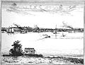
Sturgeon Bay, 1881, showing different kinds of boats
-
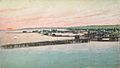
Aerial view of Sturgeon Bay around 1908
-
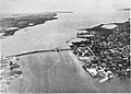
Sturgeon Bay, from a book published in 1930
-
Former Carnegie Free Library
-
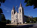
St. Joseph's Catholic Church, part of a historic area
-
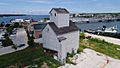
Teweles and Brandeis Grain Elevator
-
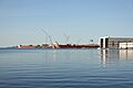
Fincantieri shipyard in Sturgeon Bay, September 2021


See also
 In Spanish: Sturgeon Bay (Wisconsin) para niños
