Menominee County, Michigan facts for kids
Quick facts for kids
Menominee County
|
|
|---|---|

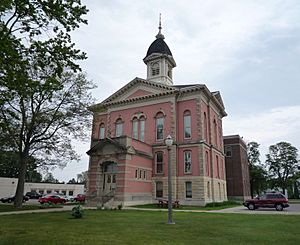
Menominee County Courthouse, Menominee
|
|

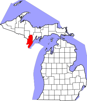
Location within the U.S. state of Michigan
|
|
 Michigan's location within the U.S. |
|
| Country | |
| State | |
| Founded | 1861 (established) 1863 (organized) |
| Named for | Menominee tribe |
| Seat | Menominee |
| Largest city | Menominee |
| Area | |
| • Total | 1,338 sq mi (3,470 km2) |
| • Land | 1,044 sq mi (2,700 km2) |
| • Water | 294 sq mi (760 km2) 22%% |
| Population
(2020)
|
|
| • Total | 23,502 |
| • Density | 23/sq mi (9/km2) |
| Time zone | UTC−6 (Central) |
| • Summer (DST) | UTC−5 (CDT) |
| Congressional district | 1st |
Menominee County is a county in the Upper Peninsula of Michigan. It is located in the northern part of the U.S. state of Michigan. In 2020, about 23,502 people lived here. The main town, or county seat, is Menominee.
The county's name comes from an Ojibwe word. It means "wild rice eater." This name describes the Menominee people. The county was first created in 1861. It was formed from part of Delta County. At first, it was called Bleeker. In 1863, when the county government started, its name changed to Menominee.
Contents
Geography of Menominee County
Menominee County covers a total area of about 1,338 square miles. Of this, 1,044 square miles is land. The remaining 294 square miles (22%) is water.
Main Roads in Menominee County
Several important roads cross Menominee County:
 US 2 – This road enters the county from Dickinson County in the west. It goes east to meet US 41 at Powers.
 US 41 – This road runs north from the southern tip of the county. It goes through Powers, Wilson, and Indiantown. Then it continues east into Delta County.
 M-35 – This road goes northeast from Menominee. It follows the edge of Green Bay and enters Delta County.
 M-69 – This road runs northwest to southeast through the northern part of the county. It passes through Labranche, Whitney, and Perronville.
Menominee County Airport
The Menominee–Marinette Twin County Airport is located in northwest Menominee. It is a public airport used for general aviation.
Neighboring Counties
Menominee County shares borders with several other counties:
Counties by Land
- Dickinson County (to the northwest)
- Marquette County (to the north)
- Delta County (to the northeast)
Counties by River
- Marinette County, Wisconsin (to the west, across the Menominee River)
Counties by Bay
- Door County, Wisconsin (to the east, across Green Bay)
Communities in Menominee County

Cities in Menominee County
- Menominee (This is the county seat, the main town for county government.)
- Stephenson
Villages in Menominee County
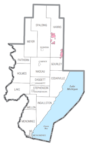
Townships in Menominee County
- Cedarville Township
- Daggett Township
- Faithorn Township
- Gourley Township
- Harris Township
- Holmes Township
- Ingallston Township
- Lake Township
- Mellen Township
- Menominee Township
- Meyer Township
- Nadeau Township
- Spalding Township
- Stephenson Township
Other Communities in Menominee County
- Birch Creek
- Cedar River
- Cunard
- Eagles Nest
- Faithorn
- Harris
- Hannahville
- Hermansville
- Indiantown
- Ingalls
- Labranche
- Leapers
- Nadeau
- Perronville
- Wallace
- Whitney
- Wilson
Indian Reservations in Menominee County
The Hannahville Indian Community has several areas of land within Menominee County. Most of these are in Harris Township. A small part also extends into Gourley Township. Another small piece goes east into Bark River Township in Delta County.
Population of Menominee County
| Historical population | |||
|---|---|---|---|
| Census | Pop. | %± | |
| 1870 | 1,791 | — | |
| 1880 | 11,987 | 569.3% | |
| 1890 | 33,639 | 180.6% | |
| 1900 | 27,046 | −19.6% | |
| 1910 | 25,648 | −5.2% | |
| 1920 | 23,778 | −7.3% | |
| 1930 | 23,652 | −0.5% | |
| 1940 | 24,883 | 5.2% | |
| 1950 | 25,299 | 1.7% | |
| 1960 | 24,685 | −2.4% | |
| 1970 | 24,587 | −0.4% | |
| 1980 | 26,201 | 6.6% | |
| 1990 | 24,920 | −4.9% | |
| 2000 | 25,326 | 1.6% | |
| 2010 | 24,029 | −5.1% | |
| 2020 | 23,502 | −2.2% | |
| 2023 (est.) | 22,945 | −4.5% | |
| US Decennial Census 1790-1960 1900-1990 1990-2000 2010-2018 |
|||
In 2020, the county had a population of 23,502 people.
Education in Menominee County
Several school districts serve Menominee County:
- Bark River-Harris School District
- Carney-Nadeau Public Schools
- Menominee Area Public Schools
- Norway-Vulcan Area Schools
- North Central Area Schools
- Stephenson Area Public Schools
Hannahville Indian School is also in the county. It is a tribal school connected with the Bureau of Indian Education. It also works as a charter school.
See also
 In Spanish: Condado de Menominee (Míchigan) para niños
 | Emma Amos |
 | Edward Mitchell Bannister |
 | Larry D. Alexander |
 | Ernie Barnes |

