Powers, Michigan facts for kids
Quick facts for kids
Powers, Michigan
|
|
|---|---|
|
Village
|
|

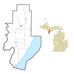
Location within Menominee County and the state of Michigan
|
|
| Country | United States |
| State | Michigan |
| County | Menominee |
| Township | Spalding |
| Founded | 1872 |
| Incorporated | 1915 |
| Area | |
| • Total | 0.94 sq mi (2.43 km2) |
| • Land | 0.94 sq mi (2.43 km2) |
| • Water | 0.00 sq mi (0.00 km2) |
| Elevation | 876 ft (267 m) |
| Population
(2020)
|
|
| • Total | 381 |
| • Density | 405.75/sq mi (156.65/km2) |
| Time zone | UTC-6 (Central (CST)) |
| • Summer (DST) | UTC-5 (CDT) |
| ZIP Code |
49874
|
| Area code(s) | 906 |
| FIPS code | 26-66140 |
| GNIS feature ID | 0635379 |
Powers is a small village located in Menominee County, in the U.S. state of Michigan. In 2020, about 381 people lived there. This was a small decrease from 422 people in 2010. Powers is part of Spalding Township and is also near the larger Marinette micropolitan area.
Contents
History of Powers
How Did Powers Get Its Name?
Long ago, this area was known as "Menominee River Junction." This was because it was where the main railroad line met the Menominee River Branch. The exact reason for the name "Powers" is not fully clear.
Some people believe the village was named after Edward Powers. He was a civil engineer who helped build the railroad in the area. Other stories say the village was founded in 1872 and named after Tom Powers. He was an engineer for the Chicago & North Western Railroad.
Geography of Powers
Where is Powers Located?
Powers is in the northern part of Menominee County. It is at a special spot where two major roads, U.S. Route 2 and U.S. Route 41, meet. These roads come together in the northeast part of the village.
U.S. Route 2 goes west about 30 miles to Iron Mountain. U.S. Route 41 goes south about 41 miles to Menominee. Menominee is the main town, or county seat, for the county. Both highways together go east about 23 miles to Escanaba, which is on Lake Michigan. The nearby community of Spalding is just northeast of Powers.
Land and Water in Powers
The U.S. Census Bureau says that Powers covers about 0.94 square miles (2.43 square kilometers) of land. There is no water area within the village limits. The Cedar River flows for a short distance through the northern part of the village.
Population of Powers
How Many People Live in Powers?
The population of Powers has changed over the years. Here is a look at how many people have lived in the village during different census years:
| Historical population | |||
|---|---|---|---|
| Census | Pop. | %± | |
| 1920 | 249 | — | |
| 1930 | 360 | 44.6% | |
| 1940 | 258 | −28.3% | |
| 1950 | 510 | 97.7% | |
| 1960 | 415 | −18.6% | |
| 1970 | 560 | 34.9% | |
| 1980 | 490 | −12.5% | |
| 1990 | 271 | −44.7% | |
| 2000 | 430 | 58.7% | |
| 2010 | 422 | −1.9% | |
| 2020 | 381 | −9.7% | |
| U.S. Decennial Census | |||
What Was the Population Like in 2010?
According to the 2010 census, there were 422 people living in Powers. Most of the people living in the village were White. A small number were Native American or Asian. About 0.9% of the population identified as Hispanic or Latino.
The average age of people in the village was about 65 years old. This means many older adults lived there. About 11.4% of residents were under 18 years old.
See also
 In Spanish: Powers para niños


