
Carney, Michigan facts for kids
Quick facts for kids
Carney, Michigan
|
|
|---|---|
|
Village
|
|

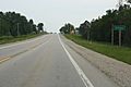
Looking south at Carney along U.S. Route 41
|
|

Location within Menominee County and the state of Michigan
|
|

Carney, Michigan
Location in Michigan

Carney, Michigan
Location in the United States
|
|
| Country | United States |
| State | Michigan |
| County | Menominee |
| Township | Nadeau |
| Area | |
| • Total | 1.37 sq mi (3.55 km2) |
| • Land | 1.37 sq mi (3.55 km2) |
| • Water | 0.00 sq mi (0.00 km2) |
| Elevation | 797 ft (243 m) |
| Population
(2020)
|
|
| • Total | 179 |
| • Density | 130.56/sq mi (50.40/km2) |
| Time zone | UTC-6 (Central (CST)) |
| • Summer (DST) | UTC-5 (CDT) |
| ZIP Code |
49812
|
| Area code(s) | 906 |
| FIPS code | 26-13400 |
| GNIS feature ID | 0622743 |
Carney is a small village located in Menominee County, which is part of the U.S. state of Michigan. In 2020, about 179 people lived there. Carney is found within Nadeau Township.
This village is also part of a larger area called the Marinette micropolitan area. This area includes Marinette, Wisconsin, and nearby communities in Michigan.
Contents
The Story of Carney
Carney started out as a stop along the Chicago and North Western Railway in 1879. This means it was a place where trains would stop, which helped the town grow.
The village got its name from a man named Frederick Carney. He owned a warehouse right where the town was built.
Where is Carney?
Carney is located in the middle of Menominee County. It sits right on U.S. Route 41, which is a major highway.
If you travel south on U.S. Route 41, you'll reach Menominee, the main city of the county, about 34 miles away. Going north for about 7 miles on the same road will take you to U.S. Route 2 near Powers.
The village is next to an unincorporated community called Nadeau to its north. Carney covers an area of about 1.37 square miles (3.55 km2), and all of it is land. A stream called Poterfield Creek flows just west of the village. This creek eventually joins the Little Cedar River.
Who Lives in Carney?
The number of people living in Carney has changed over the years. Here's a quick look at the population from different census counts:
| Historical population | |||
|---|---|---|---|
| Census | Pop. | %± | |
| 1990 | 197 | — | |
| 2000 | 225 | 14.2% | |
| 2010 | 192 | −14.7% | |
| 2020 | 179 | −6.8% | |
| U.S. Decennial Census | |||
A Closer Look at 2010
In 2010, the village had 192 people living in 83 households. About 55 of these were families. The village had 92 housing units in total.
Most of the people in Carney were White (97.4%). A small number were Native American or Asian. About 0.5% of the population identified as Hispanic or Latino.
In terms of households, about 23% had children under 18 living there. More than half (53%) were married couples. About 12% of households had someone living alone who was 65 years old or older.
The average age of people in Carney in 2010 was 47 years old. About 16% of residents were under 18. About 19% were 65 or older. The village had slightly more males (52.6%) than females (47.4%).
Pictures of Carney
-
Welcome sign
-
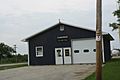
Village hall


More to Explore
 In Spanish: Carney (Míchigan) para niños
