
Ephraim, Wisconsin facts for kids
Quick facts for kids
Ephraim, Wisconsin
|
|
|---|---|

Ephraim Village Hall
|
|

Location of Ephraim in Door County, Wisconsin.
|
|
| Country | |
| State | |
| County | Door |
| Area | |
| • Total | 8.13 sq mi (21.06 km2) |
| • Land | 3.79 sq mi (9.81 km2) |
| • Water | 4.34 sq mi (11.25 km2) |
| Elevation | 663 ft (202 m) |
| Population
(2020)
|
|
| • Total | 345 |
| • Density | 42.44/sq mi (16.382/km2) |
| Time zone | UTC-6 (Central (CST)) |
| • Summer (DST) | UTC-5 (CDT) |
| Area code(s) | 920 |
| FIPS code | 55-24150 |
| GNIS feature ID | 1564680 |
Ephraim is a small village in Door County, Wisconsin, United States. It sits across Eagle Harbor from Peninsula State Park. In 2020, 345 people lived there. The village is famous for its white buildings and pretty views of the cliffs across Eagle Harbor. It also has a lovely shoreline along Green Bay.
Contents
History of Ephraim
The village of Ephraim was started in 1853. It was founded by Reverend Andreas Iverson as a Moravian religious community. The tall steeples of the Ephraim Moravian Church and the Free Evangelical Lutheran Church-Bethania Scandinavian Evangelical Lutheran Congregation are important sights. You can see them clearly from Eagle Harbor.
The Ephraim Historical Foundation helps keep the village's history alive. They preserve Reverend Iverson's home, the Anderson Store, and the Anderson Barn. They also care for the Pioneer Schoolhouse and the Goodletson log cabin. These places are open to visitors as museums. The Foundation also offers walking tours to explore the village.

For many years, Ephraim had a special rule. It did not allow the sale or making of alcohol. It was the only place in Wisconsin with this rule until 2016. People voted twice, in 1934 and 1992, to keep this rule. Most people wanted the village to stay "dry." However, on April 5, 2016, villagers voted again. This time, they decided to allow the sale of beer and wine.
Geography and Location
Ephraim is located at 45°9′23″N 87°10′16″W / 45.15639°N 87.17111°W. To the west of the village is Peninsula State Park. To the east and south are other parts of the town of Gibraltar.
The village covers about 7.16 square miles (18.54 square kilometers). About 3.79 square miles (9.82 square kilometers) of this is land. The rest, about 3.37 square miles (8.73 square kilometers), is water.
The highest point in Ephraim is about 788 feet (240 meters) above sea level. This is about 210 feet (64 meters) higher than the surface of Green Bay.

Ephraim's Climate
Ephraim has a mild climate. Summers are warm, and winters are cold.
| Weather chart for Peninsular Agricultural Research Station north of Sturgeon Bay | |||||||||||||||||||||||||||||||||||||||||||||||
|---|---|---|---|---|---|---|---|---|---|---|---|---|---|---|---|---|---|---|---|---|---|---|---|---|---|---|---|---|---|---|---|---|---|---|---|---|---|---|---|---|---|---|---|---|---|---|---|
| J | F | M | A | M | J | J | A | S | O | N | D | ||||||||||||||||||||||||||||||||||||
|
1.8
24
8
|
1.1
28
11
|
2.1
38
21
|
2.7
50
32
|
2.9
64
43
|
3.5
74
53
|
3.4
79
59
|
3.6
77
57
|
3.4
69
50
|
2.7
56
39
|
2.5
42
28
|
1.8
30
16
|
||||||||||||||||||||||||||||||||||||
| temperatures in °F precipitation totals in inches source: Climate-Charts.com |
|||||||||||||||||||||||||||||||||||||||||||||||
|
Metric conversion
|
|||||||||||||||||||||||||||||||||||||||||||||||
Population of Ephraim
| Historical population | |||
|---|---|---|---|
| Census | Pop. | %± | |
| 1920 | 196 | — | |
| 1930 | 191 | −2.6% | |
| 1940 | 254 | 33.0% | |
| 1950 | 244 | −3.9% | |
| 1960 | 221 | −9.4% | |
| 1970 | 236 | 6.8% | |
| 1980 | 319 | 35.2% | |
| 1990 | 261 | −18.2% | |
| 2000 | 353 | 35.2% | |
| 2010 | 288 | −18.4% | |
| 2020 | 345 | 19.8% | |
| U.S. Decennial Census | |||
In 2010, there were 288 people living in Ephraim. These people lived in 138 households. About 92 of these households were families. The village had many homes, with 654 housing units.
Most of the people in Ephraim were White (99.0%). A small number were Native American (0.3%) or from other races (0.7%). About 2.4% of the population was Hispanic or Latino.
In 2010, about 17.4% of households had children under 18. More than half (56.5%) were married couples. About 27.5% of households were single people living alone. Many people living alone (15.9%) were 65 years old or older.
The average age in the village was 58.8 years. About 14.9% of residents were under 18. About 33% were 65 years or older. The village had slightly more females (53.1%) than males (46.9%).
Village Events
Ephraim has a special festival called Fyr Bal. This is a Scandinavian celebration. It happens in mid-June, around the longest day of the year. The festival is meant to welcome summer.
Each year, someone is chosen to be the "Chieftain." At sunset, the Chieftain travels across Eagle Harbor on a boat. When they land in Ephraim, they light a big bonfire. Many bonfires burn along the shoreline. Residents and visitors gather to celebrate the start of summer.
Education
Students in Ephraim attend schools run by Gibraltar Area Schools. The two main schools are Gibraltar Elementary School and Gibraltar Secondary School.
Notable People
- Bert D. Thorp was a businessman and served in the Wisconsin State Assembly. He also was the president of the village of Ephraim.
Images for kids
-
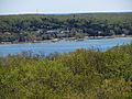
View of Ephraim from the former Eagle tower in Peninsula State Park
-
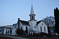
Ephraim Moravian Church
-
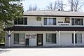
Post office
-
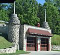
Fire station
-
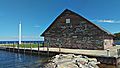
Anderson Dock; graffiti is permitted on the warehouse building within certain limits.
-
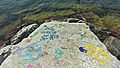
Breakwater near Anderson Dock; graffiti is not permitted on the breakwater.
-
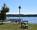
Park
-
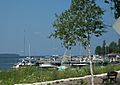
View of marina from Highway 42
-
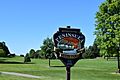
The golf course inside Peninsula State Park is within Ephraim village limits
-
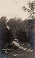
Car near the top of a dirt road near Ephraim; from a postcard postmarked in 1916


See also
 In Spanish: Ephraim (Wisconsin) para niños
