
Perry County, Missouri facts for kids
Quick facts for kids
Perry County
|
|
|---|---|

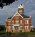
Perry County courthouse in Perryville
|
|

Location within the U.S. state of Missouri
|
|
 Missouri's location within the U.S. |
|
| Country | |
| State | |
| Founded | November 16, 1820 |
| Named for | Oliver Hazard Perry |
| Seat | Perryville |
| Largest city | Perryville |
| Area | |
| • Total | 484 sq mi (1,250 km2) |
| • Land | 474 sq mi (1,230 km2) |
| • Water | 9.8 sq mi (25 km2) 2.0% |
| Population
(2020)
|
|
| • Total | 18,956 |
| • Density | 39.17/sq mi (15.122/km2) |
| Time zone | UTC−6 (Central) |
| • Summer (DST) | UTC−5 (CDT) |
| Congressional district | 8th |
Perry County is a county in the southeastern part of Missouri, a state in the United States. In 2020, about 18,956 people lived there. The main town, or county seat, is Perryville. The county was officially started on November 16, 1820. It was named after Oliver Hazard Perry, a naval hero from the War of 1812.
Contents
History of Perry County
Early People and Cultures
The first people in what is now Perry County were the Mississippian Mound Builders. They grew corn and built large earthen mounds. These cultures lived in the area until the 12th and 13th centuries. You can still find parts of their mounds in the eastern part of the county. Later, when Europeans arrived, the area was home to Native Americans from the Illinois Confederation.
French and Spanish Control
In the 1700s, the Perry County area was part of New France, also called the Illinois Country. For most of this time, the area was mostly empty. Nearby Ste. Genevieve was the first permanent European settlement in Missouri.
In 1764, the land became Spanish territory due to the 1763 Treaty of Paris. The French settlers were not happy about this change. Spanish rule was often difficult, with some rebellions. In the Ste. Genevieve area, the Spanish often let the French manage themselves.
During the 1770s and 1780s, the Peoria Tribe moved west across the Mississippi River. They settled in Ste. Genevieve and the Bois Brule Bottoms. The French people faced problems from the Osage tribe to the southwest. In the 1790s, Spanish officials invited the Shawnee and Delaware tribes from Ohio to settle along Apple Creek. They hoped these tribes would protect the French from the Osage. Their biggest village, Le Grand Village Sauvage, had about 400 people. It was located near Old Appleton. The first French settlers in the Bois Brule Bottom were Jean Baptiste Barsaloux and his father in 1787.
American Settlers Arrive
The first American settlers came to Perry County in the late 1790s. They found rich land in the Bois Brule Bottom. These Americans started the area's first Baptist Church in 1807. In the early 1800s, more Americans came. These were Roman Catholics from Kentucky. They had moved from Maryland to avoid religious problems. Isidore Moore was one of the first to settle permanently in 1801. He founded Tucker's Settlement. Other families like Tucker, Fenwick, and Cissell soon followed. Most of them settled in the uplands around Perryville, in a place called the Barrens. Another Catholic, Joseph Fenwick, started the Fenwick Settlement near Brazeau Creek.
When the area became part of the United States in 1803–1804, the Barrens became part of the Louisiana Territory. Before Missouri became a state in 1821, new groups of settlers arrived. In 1817, many Presbyterians from North Carolina settled near Brazeau. They started a church in 1819. Methodists from the same state followed them. They built their first meeting house in 1826, which later became York Chapel.
Until 1821, the Barrens was the southern part of Ste. Genevieve County. When Missouri became a state, Perry County was formed. It was divided into three areas: Brazeau, Cinque Hommes, and Bois Brule. In 1856, the borders were made more even, and two new areas, St. Mary's and Saline, were added.
After 1821, French families from Ste. Genevieve moved into Perry County. Later, more immigrants from France arrived. They settled near the city of Perryville. Around the same time, a small group of Flemings settled in the northeastern part of the county, near the town of Belgique. There were also Swiss people in that area.
German Immigration
In the late 1830s, many German immigrants began to arrive. This changed the mix of people in the county forever. In 1838, over 600 Saxon Lutherans, led by Pastor Martin Stephan, moved to Missouri. This was called The Saxon Lutheran Migration. They wanted to avoid forced religious rules in Prussia. They settled in the southeastern part of the county. They founded towns with names that showed their religion and background: Wittenberg, Friedheim, Frohna, Dresden, Altenburg, and Paitzdorf (which became Uniontown during the American Civil War).
The Lutheran Church–Missouri Synod is a big part of the German legacy today. A special Saxon German language is still spoken by about 250 people (as of 2014), but fewer people are speaking it now.
Other German settlers were Catholics from Bavaria and Baden. They settled in the Barrens area. Lutherans and Presbyterians built churches in the Brazeau Township area. Methodists settled further west in the Cinque Hommes Township. They built two churches, York Chapel and one in Perryville. In 1844–1845, the Methodist churches split over a disagreement. The Perryville church joined the North, and York Chapel joined the South. Baptists in the county met in private homes in the Bois Brule Bottom and Saline Township areas.
Perry County is one of the oldest communities in Missouri. It also founded the first college west of the Mississippi River in 1827.
Geography
Perry County is shaped a bit like a camel's hump. It covers about 471 square miles (1,220 km²) of land. It fits into a space where Apple Creek meets the Mississippi River. The land has two main types: lowlands and uplands.
The lowlands make up about one-eighth of the county. They are mostly along the river. In the northeast is the Bois Brule Bottom. This means "Burnt Wood." It is the largest lowland area, about 15 miles (24 km) long and up to 5 miles (8 km) wide. Its rich soil makes it the best farmland in the county. The Brazeau Bottom and the area near Apple Creek are also important lowlands.
The uplands make up most of the county. Their landscape changes a lot. The best parts are in the middle, where the soil is good and the land is mostly flat or gently rolling. Rolling uplands surround this central area. To the west are the Saline Hills, and to the east are the Mississippi River Hills and Bluffs.
The U.S. Census Bureau says the county has a total area of 484 square miles (1,250 km²). Of this, 474 square miles (1,230 km²) is land, and 9.8 square miles (25 km²) (2.0%) is water. Perry County is located across the Mississippi River from Illinois.
Neighboring Counties
- Randolph County, Illinois (north)
- Jackson County, Illinois (northeast)
- Union County, Illinois (east)
- Cape Girardeau County (southeast)
- Bollinger County (southwest)
- Madison County (southwest)
- St. Francois County (northwest)
- Ste. Genevieve County (northwest)
Main Roads
 Interstate 55
 U.S. Route 61
 Route 51
Protected Natural Areas
People and Population (Demographics)
| Historical population | |||
|---|---|---|---|
| Census | Pop. | %± | |
| 1830 | 3,349 | — | |
| 1840 | 5,760 | 72.0% | |
| 1850 | 7,215 | 25.3% | |
| 1860 | 9,128 | 26.5% | |
| 1870 | 9,877 | 8.2% | |
| 1880 | 11,895 | 20.4% | |
| 1890 | 13,237 | 11.3% | |
| 1900 | 15,134 | 14.3% | |
| 1910 | 14,898 | −1.6% | |
| 1920 | 14,434 | −3.1% | |
| 1930 | 13,707 | −5.0% | |
| 1940 | 15,358 | 12.0% | |
| 1950 | 14,890 | −3.0% | |
| 1960 | 14,642 | −1.7% | |
| 1970 | 14,393 | −1.7% | |
| 1980 | 16,784 | 16.6% | |
| 1990 | 16,648 | −0.8% | |
| 2000 | 18,132 | 8.9% | |
| 2010 | 18,971 | 4.6% | |
| 2020 | 18,956 | −0.1% | |
| U.S. Decennial Census 1790-1960 1900-1990 1990-2000 2010-2015 2020 |
|||
In 2000, there were 18,132 people living in Perry County. There were 6,904 households and 4,957 families. The population density was about 38 people per square mile (15 people/km²).
Most people (98.21%) were White. About 0.18% were Black or African American. Around 0.23% were Native American. About 0.65% were Asian. About 0.51% of the population was Hispanic or Latino.
About 34.20% of households had children under 18. Most households (60.50%) were married couples. The average household had 2.57 people, and the average family had 3.07 people.
The median age in the county was 37 years old. About 26.00% of the population was under 18. About 15.70% were 65 or older.
The median income for a household was $44,264. For a family, it was $53,034. About 9.00% of the population lived below the poverty line.
Religion
Perry County is different from many other rural counties in southeastern Missouri. Roman Catholicism is the main religion here. According to a 2000 report, 60.33% of religious residents are Roman Catholics. Also, 29.72% are Lutherans.
Perry County has the second highest percentage of Catholics in Missouri. It also has the second highest percentage of Lutherans in the state.
|
Roman Catholic Churches
|
Lutheran Churches
|
Presbyterian Churches
Methodist Churches
Baptist Churches
|
2020 Census Data
| Race | Num. | Perc. |
|---|---|---|
| White (NH) | 17,657 | 93.15% |
| Black or African American (NH) | 102 | 0.54% |
| Native American (NH) | 29 | 0.15% |
| Asian (NH) | 123 | 0.65% |
| Pacific Islander (NH) | 0 | 0% |
| Other/Mixed (NH) | 662 | 3.5% |
| Hispanic or Latino | 383 | 2% |
Education
In Perry County, about 71.2% of adults aged 25 and older have a high school diploma. About 9.9% have a bachelor's degree or higher.
Public Schools
- Altenburg 48 Elementary School - Altenburg - (Grades K-8)
- Perry County School District No. 32 - Perryville
- Perryville Early Childhood Special Education Center (Preschool)
- Perryville Elementary School (Grades K-4)
- Perry County Middle School (Grades 5-8)
- Perryville High School (Grades 9-12)
- Perryville Area Career & Technology Center (Grades 9-12)
Private Schools
- United in Christ Lutheran School - Frohna - (Preschool-Grade 8) - Lutheran Church–Missouri Synod
- Immanuel Lutheran School, Perryville - (Preschool-Grade 8) - Lutheran Church–Missouri Synod
- St. Vincent De Paul Schools, Perryville - (Preschool-Grade 12) - Roman Catholic
- St. Vincent De Paul Elementary School (Preschool-Grade 6)
- St. Vincent De Paul High School (Grades 7-12)
Public Libraries
- Altenburg Branch Library
- Perryville Branch Library
Things to See and Do (Tourism & Attractions)
Perry County has many historic, architectural, and beautiful places to visit.
You can explore the St. Mary's of the Barrens Seminary. This was the first college founded west of the Mississippi River in 1827. Other attractions include the National Shrine of Our Lady of the Miraculous Medal. There is also the Rosati Log Cabin and the Countess Estelle Doheny Museum. This museum has a very rare Gospel of St. John from the Gutenberg Bible. The Bishop Edward Sheehan Memorial Museum also has rare books. You can take guided tours of the museums.
In Perryville, the county seat, you can walk around the beautiful square. The Perry County Courthouse was built in 1904. It has a clock tower that chimes. The square has new streets, sidewalks, and lights. It also has brick-paved areas, benches, a sundial, and a gazebo.
On the northeast corner of the square is the Levi Block building. It was built around 1829 and is thought to be the oldest business building in Perryville. It is now Hilderbrand Jewelers.
The Faherty House at 11 S. Spring Street was built in 1825. It was a two-room stone house with a basement. It is believed to be the oldest house still standing in the city. A brick addition was built in the 1850s. The Perry County Historical Society owns and takes care of this restored house.
The Perry County Museum is at the entrance of the Perryville City Park. It is in the Doerr House and is open on Wednesdays and weekends from May to October.
In southeastern Perry County, near the Mississippi River, are the old German villages of Frohna, Altenburg, and Wittenberg.
The Saxon Lutheran Memorial in Frohna helps keep the history of the 1839 Saxon Immigration alive. It has two original log houses, a large log barn, old tools, and farm machines. There is also a visitor's center and a gift shop.
In Altenburg, you can visit the Concordia Log Cabin College (1839). This was the first Lutheran Seminary west of the Mississippi River. You can also see the Loeber Log Cabin (1839) and Trinity Lutheran Church (1867). Guided tours of historic Altenburg can be arranged.
If you travel south, you can visit the Tower Rock Natural Area. This is a national landmark with a 10-mile (16 km) hiking trail. Tower Rock is a 60-foot (18 m) high rock in the Mississippi River. Its history goes back to 1698. Nearby, the early 1800s settlement of Apple Creek has the Lady of St. Joseph Shrine.
Perry County has about 650 known caves. It has more caves than any other county in Missouri, which is called "The Cave State."
Communities
Cities
- Altenburg
- Frohna
- Perryville (county seat)
Village
Census-designated places
Unincorporated communities
Former Communities
Townships
Images for kids
-
Perry County courthouse in Perryville
See also
 In Spanish: Condado de Perry (Misuri) para niños
