
Brazeau Bottom facts for kids
Quick facts for kids Brazeau Bottom |
|
|---|---|

Brazeau Bottoms in winter
|
|
| Location | Missouri, United States |
The Brazeau Bottom is a flat, low-lying area of land next to the Mississippi River in Perry County, Missouri. It's a type of floodplain, which means it's formed by alluvial deposits (silt, sand, and clay) left behind by rivers during floods.
This flat land is located along the western bank of the Mississippi River. It sits below other similar areas called the American and Bois Brule bottoms. The Brazeau Bottom is about 3 miles long. It starts after a series of rocky cliffs, including the Red Rock Landing and Seventy-Six Conservation Areas. Brazeau Creek forms the southern edge of this area.
Contents
What's in a Name?
The Brazeau Bottom gets its name from the nearby Brazeau Creek. The creek itself was named after Joseph Brazeau. He was a merchant from St. Louis who lived there between 1791 and 1799. It might have been named after him or someone else in his family.
Early Days and Settlers
The land of Brazeau Bottom was first given out by the Spanish government. Joseph Manning received one of the first grants. The first European settler to actually live there was George A. Hamilton. He was Catholic and came from Maryland. Hamilton moved to Brazeau Bottom in 1797 after getting permission from the Spanish.
Other early settlers arrived soon after. These included Hinckson in 1800 and Joseph James in 1801. David L. Johnson and William Johnson from Kentucky settled there in 1802. In 1803, Joseph Fenwick and about twenty other Catholic families from Kentucky started the Fenwick Settlement. This settlement was located near where Brazeau Creek flows into the Mississippi River. Later, in 1838-1839, many German settlers arrived. They were part of the German Saxon Lutheran immigration. These new settlers helped establish the town of Wittenberg.
Floods and Their Impact
Over the years, Brazeau Bottom has experienced many floods. The great flood of 1927 and the flood of 1973 caused a lot of damage. The 1973 flood was especially tough. It destroyed most of the businesses in Wittenberg and caused many people to move away.
Where is Brazeau Bottom?
Brazeau Bottom is in the southeastern part of Perry County, Missouri. Its elevation is about 368 feet (109 meters) above sea level. Brazeau Creek flows through this area and eventually empties into the Mississippi River near Wittenberg.
A long structure called the Grand Tower Pipeline Bridge crosses the Mississippi River here. It's 2,161 feet long and carries a natural gas pipeline from Wittenberg to Grand Tower, Illinois. At the southern end of Brazeau Bottom, you can find a unique rock formation called Tower Rock. Interestingly, Grand Tower Island is just across the Mississippi River to the east. Even though it's on the east side of the river, it's still part of Perry County, Missouri!
Towns in Brazeau Bottom
Gallery
-
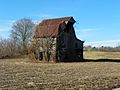
Old Barn in the bottoms
-
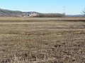
Bottomland with power plant in background
-
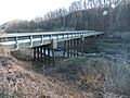
Bridge over Brazeau Creek


