
Grand Tower Island facts for kids

Grand Tower Island is a special piece of land found in the middle of the Mississippi River. It's located right on the border between Missouri and Illinois in the central United States. This island wasn't always here! It formed over time as the river changed its path, creating a unique bulge of land. One side of the island faces the main river, and the other side is next to a calm, curved lake. The land on Grand Tower Island is great for farming, especially when it's protected from floods. The lake next to it is also very popular for sport fishing.
Contents
Where is Grand Tower Island?

Grand Tower Island is on the eastern side of the Mississippi River. It's in a quiet area between the cities of St. Louis, Missouri, and Cairo, Illinois. The island shares its name with the nearby town of Grand Tower, Illinois. It's also close to a famous rock formation called Tower Rock on the Missouri side of the river.
Even though Grand Tower Island is on the Illinois side of the river and has roads connecting to Illinois, it's actually part of Brazeau Township, Perry County, Missouri. This is a bit like how the village of Kaskaskia, Illinois is on the "wrong" side of the river but is still part of Illinois. A long, narrow island, about 1 mile (1.6 km) long, sits in the river between Grand Tower Island and the Missouri mainland.
How the Island Formed
The reason Grand Tower Island is on the "wrong" side of the Mississippi River is because the river changed its course a long time ago. Back when steamboats first started using the river, the main path of the river curved around. But over time, the river found a shorter way to flow, cutting off the old curve. This old curve then became a still, U-shaped lake called an oxbow lake.
Some parts of this lake can dry up when it's hot, but sometimes it connects back to the main river for a short time. Usually, its water slowly flows into the nearby Big Muddy River, which then joins the Mississippi. Grand Tower Island is about 2 miles (3.2 km) wide from east to west and 2.75 miles (4.4 km) long from north to south. A single road, Island Road, runs north to south across it. This road then turns east, goes along the narrow land between the lake and the Big Muddy River, and finally connects to Illinois Route 3. To get to the rest of Perry County, Missouri, you have to drive more than 30 miles (48 km) and cross the Chester Bridge at Chester.
Fishing in the Lake

The lake next to Grand Tower Island is known as "Tower Island Chute" or "Grand Tower Chute." Many trees grow along the lake's edges, and their fallen logs and branches create perfect hiding spots for fish. This makes it a great place for fish like crappie and bass.
In the 1960s, newspapers like the Southeast Missourian often wrote about how many crappie were in this lake, even more than in other popular fishing spots like Horseshoe Lake. The lake also has a large population of carp, so big that it was included in a carp-fishing contest in the early 2010s.
Between 2006 and 2007, scientists from Southern Illinois University Carbondale studied fish in different parts of the Mississippi River, including Grand Tower Chute. They found that the water in Grand Tower Chute had a higher amount of certain elements, like barium and strontium, compared to other areas. This means the fish living there might have different chemical makeups than fish from other lakes.
Farming and Flooding
Grand Tower Island is connected to the Illinois mainland by a strong protective wall called a levee. This levee was built in late 1910 using soil and rocks that were dug up from the river. The part of the island between the levee and the river is about 900 acres (364 hectares). This land is all privately owned and mostly covered in forest, though some parts are used for farming. Some areas are wet and not good for farming right now.
Almost all the land behind the levee is used for farming. The only exception is a thin line of trees that provides the deadwood, which is so good for fish habitat. Experts say that most of the land on the island is "prime farmland," meaning it's excellent for growing crops. Only a few spots might need extra water drainage to become fully productive. The good news is that the land behind the levee doesn't flood very often.
Images for kids
-
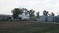
Buildings at the island's only farm
-
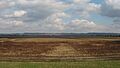
Fields in the island's southern portion
-
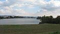
Northern end of the lake
