Tower Island facts for kids

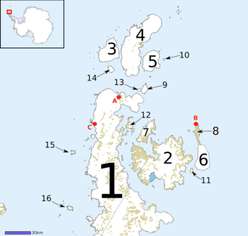
Map of Graham Land, showing Tower Island (16)
|
|
|
Location in Antarctica
|
|
| Geography | |
|---|---|
| Location | Antarctica |
| Coordinates | 63°34′S 059°50′W / 63.567°S 59.833°W |
| Archipelago | Palmer Archipelago |
| Length | 9 km (5.6 mi) |
| Highest elevation | 305 m (1,001 ft) |
| Administration | |
| Administered under the Antarctic Treaty System | |
| Demographics | |
| Population | Uninhabited |
Tower Island is an island in Antarctica. It is about 5 nautical miles (9 km) long. The island reaches a height of 305 meters (1,001 feet).
Tower Island marks the northeast edge of the Palmer Archipelago. It is located 20 nautical miles (37 km) northeast of Trinity Island. These two islands are separated by Gilbert Strait. Tower Island and Trinity Island are also separated from the Davis Coast by Orléans Strait. The Pearl Rocks are small rocks found off the west coast of Tower Island.
Contents
How Tower Island Got Its Name
Tower Island was named on January 30, 1820. It was named by Edward Bransfield, a Master in the Royal Navy. He described the island as being round, like a tower.
Exploring Tower Island's Features
Many parts of Tower Island have been mapped and named by different groups exploring Antarctica. Let's look at some of these features, starting from the north and moving around the island's coast.
East Coast Features
The northernmost point of Tower Island is called Cape Leguillou. A French expedition mapped it between 1837 and 1840. They named it after Élie Le Guillou, a surgeon on their ship, the Zélée. This name has been used ever since.
Just east of Cape Leguillou is Ploski Cove. This cove is about 1 kilometer (0.6 miles) wide. It goes into the coast by about 850 meters (2,789 feet). Ploski Cove is named after a village called Ploski in Bulgaria. Traverso Point forms the southeastern edge of this part of the coast.
Further south along the east coast is Harmanli Cove. This cove is about 1.1 kilometers (0.7 miles) wide and goes into the coast by the same distance. It is named after the town of Harmanli in southeastern Bulgaria.
South of Harmanli Cove is Cape Dumoutier. This is the easternmost tip of Tower Island. It was named by the same French expedition after Pierre Dumoutier, another surgeon.
Continuing south, you will find Breste Cove. This cove is 700 meters (2,297 feet) wide and 850 meters (2,789 feet) deep. It is named after the settlement of Breste in northern Bulgaria. South of Breste Cove is Castillo Point.
Condyle Point is the southeast point of the island. The UK Antarctic Place-Names Committee (UK-APC) named it. A "condyle" is a rounded part at the end of a bone. This name describes the shape of the point.
The southernmost point of Tower Island is Peña Point.
West Coast Features
On the west coast of Tower Island, you will find Ustina Point. This is a rocky point named after the settlement of Ustina in southern Bulgaria. It is located about 2.6 kilometers (1.6 miles) northwest of Peña Point.
Closer to the north end of the island is Kranevo Point. This point is named after the Bulgarian village of Kranevo. It forms the south side of the entrance to Mindya Cove. Mindya Cove is named after Mindya, Bulgaria. It is a wide cove, about 2.4 kilometers (1.5 miles) across. It goes into the island's northwest coast for about 1.5 kilometers (0.9 miles).
Coastal Rocks
Around Tower Island, there are several groups of rocks:
- Dumoulin Rocks
- Kendall Rocks
- Pearl Rocks
See also
In Spanish: Isla Torre (Palmer) para niños
 | Percy Lavon Julian |
 | Katherine Johnson |
 | George Washington Carver |
 | Annie Easley |


