Trinity Island facts for kids
| Geography | |
|---|---|
| Location | Antarctica |
| Coordinates | 63°47′S 60°44′W / 63.783°S 60.733°W |
| Archipelago | Palmer Archipelago |
| Length | 24 km (14.9 mi) |
| Width | 10 km (6 mi) |
| Administration | |
| Administered under the Antarctic Treaty System | |
| Demographics | |
| Population | 0 |
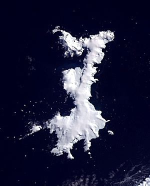
Trinity Island is a cool island in Antarctica. It's about 24 kilometers (15 miles) long and 10 kilometers (6 miles) wide. You can find it in the northern part of the Palmer Archipelago. This group of islands is near the Antarctic Peninsula.
The island got its name from Otto Nordenskiöld. He led a Swedish expedition to Antarctica from 1901 to 1904. He named it to remember "Trinity Land," which was seen by Edward Bransfield in 1820.
Contents
History of Trinity Island
Trinity Island might have been the first part of Antarctica ever seen! An American sealer named Nathaniel Palmer might have spotted it on November 16, 1820. He was exploring south from Cape Horn in his small boat. He was looking for places where seals lived.
Later, in 1897, the whole group of islands was named after Palmer. This was done by Adrien de Gerlache. He was the leader of the Belgian Antarctic Expedition.
Exploring Trinity Island's Geography
Trinity Island is one of the islands furthest north in the Palmer Archipelago. This chain has over fifty islands. They run next to the coast of the Antarctic Peninsula.
The island is about 24 kilometers (15 miles) long and 10 kilometers (6 miles) wide. It has a very bumpy shape. Its coastline has many points, capes, and bays. Many of these places have been mapped and named. Different expeditions and countries like Argentina and Bulgaria have named them.
Trinity Island is separated from Tower Island by a water channel called Gilbert Strait. Both islands are also separated from the Davis Coast by Orléans Strait. To the southwest, a narrow passage called Chayka Passage separates Trinity Island from Spert Island. They are only about 110 meters (360 feet) apart!
Northern Parts of the Island
Cape Wollaston is at the very northwest tip of the island. It was named after William H. Wollaston. He was part of the Royal Society a long time ago.
East along the north coast is Lorna Cove. It's about 1.1 kilometers (0.7 miles) wide. Albatros Point, which is covered in ice, marks its eastern side. These places are named after Bulgarian fishing boats.
Further east, Cape Neumayer forms the northeast end of Trinity Island. It was named after a German scientist, Georg B. von Neumayer.
On the west coast, Preker Point is southwest of Cape Wollaston. It's named after a mountain in Bulgaria. This point marks the northern part of Saldobisa Cove. This cove is 2.3 kilometers (1.4 miles) wide. It's named after an old Thracian settlement in Bulgaria.
Burya Point divides Saldobisa from Olusha Cove to the south. It's named after a village in Bulgaria. Olusha Cove is 2.7 kilometers (1.7 miles) wide. It's named after another Bulgarian fishing boat. Consecuencia Point marks its southern side.
Further south on the west coast is Milburn Bay. It's near Lyon Peak. This bay was named after M. R. Milburn. He was an air traffic control officer who helped map the area.
Southern Parts of the Island

Towards the southern end of the west coast is Krivina Bay. This bay is 5 kilometers (3.1 miles) wide and goes 3 kilometers (1.9 miles) deep into the coast. There are three small, rocky islands in the northern part of the bay. These islands are named Imelin, Dink, and Rogulyat. The bay and its islands are named after places in Bulgaria.
On the southwest side of the island is Belimel Bay. It's 5.9 kilometers (3.7 miles) wide. It's named after a place in northwestern Bulgaria. This bay is bordered by Spert Island to the north. Asencio Point is to the south. Tizoin Point sticks out into the middle of the bay. It's named after a cave in Bulgaria.
The southernmost tip of the island is called Skottsberg Point. This point marks the west side of Mikkelsen Harbor. This harbor is a very important feature on the southern part of the island.
Rocks and Reefs Near Trinity Island
The Hydrodist Rocks are about 4 nautical miles (7.4 km) off the west coast. They were first located in 1964.
Judas Rock is about 5 nautical miles (9.3 km) west of the island's southwest end. It was named because it marks the end of a dangerous shallow area. This area stretches north for 3 nautical miles (5.6 km).
Important Bird Areas: Home to Antarctic Wildlife
Trinity Island is a special place for birds! Some areas have been named "Important Bird Areas" (IBAs). This means they are very important for bird populations.
Cape Wollaston: A Bird Hotspot
Cape Wollaston is at the northwest tip of the island. It's an IBA because it's home to a huge group of southern fulmars. About 10,000 pairs of these birds breed here! This area is 116 hectares (287 acres) of land that isn't covered in ice. It's about 250 meters (820 feet) high.
Southwest Trinity Island: More Bird Life
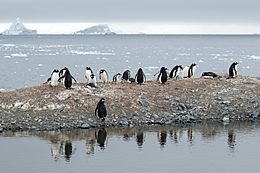
Another IBA is on the southwest side of the island. It's a rocky headland that rises to 250 meters (820 feet) above the sea. This spot is important for about 200 pairs of Antarctic shags. These birds also breed here. You can also find Chinstrap penguins nesting at this site!
See also
 In Spanish: Isla Trinidad (Antártida) para niños
 | Misty Copeland |
 | Raven Wilkinson |
 | Debra Austin |
 | Aesha Ash |


