
Bois Brule Bottom facts for kids
Quick facts for kids Bois Brule Bottom |
|
|---|---|

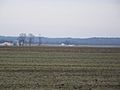
Bois Brule Bottoms
|
|
| Type | Alluvial floodplain |
| Location | Perry County, Missouri, United States |
The Bois Brule Bottom is a large, flat area of land in Perry County, Missouri. Its name comes from French, meaning "Burnt Wood." This area is a floodplain, which means it's a flat piece of land next to a river that can get flooded. It stretches between Bois Brule Creek to the west and the mighty Mississippi River to the east.
This bottomland is part of a bigger floodplain system. It connects to the American Bottom which runs along the east side of the Mississippi River. South of Kaskaskia Island, the Bois Brule Bottom begins. It is bordered by an old channel of the Mississippi River to the north and Cinque Hommes Creek to the south.
Contents
What's in a Name?
The name "Bois Brûlé" comes from the French language. It means "Burnt Wood." Early French settlers gave this name to the area. They probably saw a part of the forest that had been burned.
A Look Back: History of Bois Brule Bottom
Early People: Native Americans
The first known people to live in the Bois Brule Bottom area were the Mound Builders. These groups built large earthen mounds along the Mississippi River. By the 12th and 13th centuries, their culture, called the Mississippian culture, slowly faded away.
Later, other Native American groups lived here. The Kaskaskia Indians came from what is now Peoria, Illinois. They moved south to the area near Kaskaskia, Illinois. In the late 1700s, parts of the Illinois Confederation, like the Peoria people, moved across the Mississippi River. They settled in places like Ste. Genevieve, Missouri and about 100 people came to the Bois Brule Bottom. They wanted to escape problems with the British and Americans.
French Settlers Arrive
The first Europeans to settle in this part of the Mississippi River region were the French. This whole area, on both sides of the river, was called the Illinois Country. It was part of New France.
Several French communities were already set up north of Bois Brule Bottom. These included Kaskaskia, Illinois, Ste. Genevieve, Missouri, and Prairie du Rocher, Illinois. In 1763, the Spanish took control of this area. It became part of New Spain. One of the first settlers in Bois Brule was Jean Baptiste Barsaloux. He was a traveling merchant who lived there in 1787.
Americans Make Their Home
In the late 1700s and early 1800s, the Spanish government allowed American Catholics from Kentucky to settle in Bois Brule Bottom. These were sometimes called "Maryland Catholics." They included people like Levy Wiggins and William Boyce. These American Catholics chose to live separately from the French settlers. Many left the area by 1820.
Other Americans also settled in Bois Brule Bottom. The Fenwick Settlement, Missouri was started in the late 1790s. It was founded by the Fenwick brothers: Walter, Ezekial, Thomas, and James. They were also Maryland Catholics who had first settled in Kentucky.
Another group of settlers were Irish Catholics. They arrived in the late 1790s and settled along Bois Brule Creek. Even though the soil was very good for farming, early settlers faced many problems. The land was flat and wet, leading to swamps, mosquitoes, and illnesses like malaria and typhoid fever.
In 1804, the United States took control of this territory. By the 1820s, many more American settlers moved into the region. After Missouri became a state in 1821, Bois Brule Bottom was reorganized. It became a township in Perry County, Missouri.
Dealing with Floods
Flooding has always been a big worry for people living in Bois Brule Bottom. In the past, under French and Spanish rule, every settler had to build and take care of levees on their land. Levees are walls built to hold back water.
Many floods happened throughout the 1800s and 1900s. But the Great Flood of 1993 was especially bad. It caused a lot of damage to the Bois Brule Bottom. Many communities struggled to recover after this huge flood.

Today, the US Army Corps of Engineers manages the Bois Brule Levee and Drainage District. They are in charge of keeping the levees and water channels in good condition.
Where is Bois Brule Bottom?
The Bois Brule Bottom is about 360 feet (109 meters) above sea level. It is a very fertile area, great for farming. The bottomland is about six miles wide and eighteen miles long.
To the north, it is bordered by the Old River. This is an old channel of the Mississippi River that changed course after the Great Flood of 1844. This old channel separates Bois Brule Bottom from Kaskaskia Island. Cinque Hommes Creek forms the southern border. Bois Brule Creek and the Mississippi bluffs are to the west, and the Mississippi River is to the east.
Communities in the Bois Brule Bottom
Images for kids
-
Bois Brule Bottoms
-
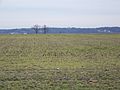
Fields in Bois Brule
-
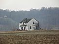
An abandoned house that was flooded out


