Claryville, Missouri facts for kids
Quick facts for kids
Claryville, Missouri
|
|
|---|---|

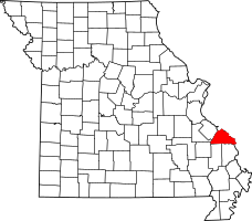
Location of Perry County, Missouri
|
|
| Country | United States |
| State | Missouri |
| County | Perry |
| Township | Bois Brule |
| Elevation | 374 ft (114 m) |
| Time zone | UTC-6 (Central (CST)) |
| • Summer (DST) | UTC-5 (CDT) |
| ZIP code |
63775
|
| Area code(s) | 573 |
| FIPS code | 29-14230 |
| GNIS feature ID | 735559 |
Claryville is a small, unincorporated community located in Perry County, Missouri, in the United States. This means it's not a city with its own local government. You can find Claryville about twelve miles northeast of Perryville. It's also right next to the mighty Mississippi River, about sixty-three miles south of the big city of Saint Louis.
Contents
The Name of Claryville
How Claryville Got Its Name
The community was originally spelled Clearyville. It was named after a farmer in the area named John Cleary. Over time, people started saying "Claryville," and the spelling was changed to match how it sounded. For a while, some people also called it West Chester unofficially.
Land for John W. Clary
A person named John W. Clary received land in this area because of his service in the Mexican–American War. He was given 160 acres of land, which was the largest amount allowed at that time. This happened under a special law from 1847.
History of Claryville
When Claryville Was Settled
Claryville was first settled in 1869. The town was officially planned out and mapped in 1871. The first mayor of Claryville was V.P. Tucker. The first person to open a store there was E. J. Rhodes.
Claryville in the Early 1900s
By 1912, Claryville had three general stores where people could buy everyday items. At that time, about 140 people lived in the community.
Challenges from Flooding
Over the years, Claryville has faced many floods. Because of its location near the river, floods have caused the population to get smaller.
Where Claryville Is Located
Claryville is found in the Mississippi River Valley. This area is a flat, low-lying plain called the Bois Brule Bottom. Being so close to the Mississippi River means that Claryville is often at risk of flooding.
 | Frances Mary Albrier |
 | Whitney Young |
 | Muhammad Ali |

