
Frohna, Missouri facts for kids
Quick facts for kids
Frohna, Missouri
|
|
|---|---|

Frohna, Missouri, road sign
|
|

Location of Frohna, Missouri
|
|
| Country | United States |
| State | Missouri |
| County | Perry |
| Township | Brazeau |
| Area | |
| • Total | 0.90 sq mi (2.34 km2) |
| • Land | 0.90 sq mi (2.34 km2) |
| • Water | 0.00 sq mi (0.00 km2) |
| Elevation | 568 ft (173 m) |
| Population
(2020)
|
|
| • Total | 245 |
| • Density | 271.32/sq mi (104.79/km2) |
| Time zone | UTC-6 (Central (CST)) |
| • Summer (DST) | UTC-5 (CDT) |
| ZIP code |
63748
|
| Area code(s) | 573 |
| FIPS code | 29-26092 |
| GNIS feature ID | 2394828 |
Frohna is a small village located in Perry County, Missouri, United States. It is a quiet community with a rich history. In 2020, about 245 people lived there. Frohna is known for its strong ties to German heritage.
Contents
The Name Frohna
The village of Frohna gets its name from a town in Germany. It was named after Niederfrohna, which means "Lower Frohna." This German town is located in the Saxony region. Over time, the "Nieder-" part of the name was dropped. So, the village became simply Frohna.
A Glimpse into Frohna's History
Frohna was founded in 1839 by German immigrants. These settlers came from the Saxony region of Germany. They established seven towns and villages in this area. Frohna was one of them.
Other towns founded by these immigrants include Altenburg, Dresden, Johannisberg, Paitzdorf, Seelitz, and Wittenberg. All these places were named after towns in their homeland. This shows how important their German roots were to them.
Frohna's Geography
Frohna is located in Perry County, Missouri. It covers a total area of about 0.90 square miles (2.34 square kilometers). All of this area is land, with no significant bodies of water.
Community Life in Frohna


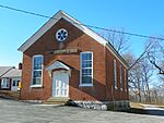
The Concordia Lutheran Church is an important part of the community. It belongs to the Lutheran Church–Missouri Synod.
Every October, the village hosts the Saxon Fall Festival. This festival takes place at the Saxon Lutheran Memorial. The memorial honors the German Lutheran immigrants who arrived in 1838 and 1839. It features several old log cabins from that time. These cabins help visitors imagine what life was like for the early settlers.
Population of Frohna
| Historical population | |||
|---|---|---|---|
| Census | Pop. | %± | |
| 1880 | 97 | — | |
| 1950 | 208 | — | |
| 1960 | 216 | 3.8% | |
| 1970 | 225 | 4.2% | |
| 1980 | 265 | 17.8% | |
| 1990 | 162 | −38.9% | |
| 2000 | 192 | 18.5% | |
| 2010 | 254 | 32.3% | |
| 2020 | 245 | −3.5% | |
| U.S. Decennial Census 2020 | |||
The population of Frohna changes over time. In 2010, there were 254 people living in the village. This included 102 households and 74 families. The population density was about 282 people per square mile.
Most of the people living in Frohna are White. About 26% of residents were under 18 years old in 2010. The average age was around 39.7 years. The village had a fairly even number of males and females.
Gallery
-
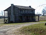
Saxon Lutheran Memorial
-
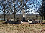
Carl Ferdinand Wilhelm Walther statue
-
Saxon Memorial
-
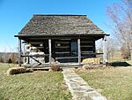
Saxon Lutheran Memorial cabin
-
Die Kleine Schule
-
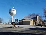
Watertower
-
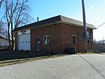
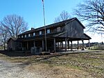
City Hall


Nearby Communities

See also
 In Spanish: Frohna (Misuri) para niños
