
Saxony facts for kids
Quick facts for kids
The Free State of Saxony
Freistaat Sachsen
Swobodny Stata Sakska |
|||
|---|---|---|---|
|
|||

Position of Saxony within Germany
|
|||
| Country | Germany | ||
| Capital | Dresden | ||
| Area | |||
| • Total | 18,415 km2 (7,110 sq mi) | ||
| Population
(December 2008)
|
|||
| • Total | 4,192,700 | ||
| • Density | 227.679/km2 (589.685/sq mi) | ||
| Time zone | UTC+1 (CET) | ||
| • Summer (DST) | UTC+2 (CEST) | ||
| Website | sachsen.de | ||


The Free State of Saxony (which is Freistaat Sachsen in German and Swobodny Stata Sakska in Sorbian) is one of the 16 states of Germany. It is located in the southeast part of Germany. To its north is the Czech Republic, and to its east is Poland.
The largest city in Saxony is Leipzig. The capital city is Dresden. Saxony was officially started again in 1990 after Germany became one country again.
Contents
Exploring Saxony's Geography
Saxony shares its borders with two countries: Poland and the Czech Republic. To the north of Saxony, you'll find Brandenburg, which is another German state. On Saxony's western side are the states of Saxony-Anhalt, Thuringia, and Bavaria. A large part of the border with the Czech Republic is formed by the Ore Mountains in the south of Saxony. These mountains are a beautiful natural feature.
Major Cities and Towns
Saxony is home to many interesting cities and towns. Here are some of the biggest ones:
| City | District | People (2006) | People (2008) |
|---|---|---|---|
| Leipzig | Leipzig (city) | 506,260 | 511,676 |
| Dresden | Dresden (city) | 504,635 | 508,398 |
| Chemnitz | Chemnitz (city) | 245,739 | 244,310 |
| Zwickau | Zwickau Rural District | 96,878 | 95,322 |
| Plauen | Vogtlandkreis | 68,317 | 67,309 |
| Görlitz | Görlitz Rural District | 57,201 | 56,608 |
How Saxony is Divided: Districts
Saxony is split into 3 main administrative areas. Think of these as big regions that help manage the state. These regions are Chemnitz, Dresden, and Leipzig.
These three big areas are then divided into 10 smaller parts called districts. Each district has a special code that you might see on car license plates.
- Bautzen (BZ)
- Erzgebirgskreis (ERZ)
- Leipzig (L)
- Meißen (MEI)
- Mittelsachsen (FG)
- Görlitz (GR)
- Nordsachsen (TDO)
- Sächsische Schweiz-Osterzgebirge (PIR)
- Vogtlandkreis (V)
- Zwickau (Z)

Special Urban Districts
Besides the rural districts, Saxony also has three special urban districts. These are big cities that manage themselves and don't belong to any rural district. They are:
A Look at Saxony's History
The first "Free State of Saxony" was created in 1918. This happened after the First World War ended.
After the Second World War in 1945, the "country of Saxony" was formed. However, this "country" was later divided into three smaller parts. This meant it lost its ability to govern itself.
Then, in 1990, the Free State of Saxony was officially started again. It became a part of a reunited Germany.
How Many People Live in Saxony?
The number of people living in Saxony has changed over the years. Here's a look at the population since 1905:
|
|
Images for kids
-
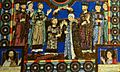
Henry the Lion (with his wife Matilda of England, Duchess of Saxony) being crowned as the Duke of Saxony
-
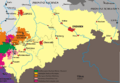
The Kingdom of Saxony after the Congress of Vienna
-
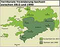
Saxony before the Congress of Vienna compared to present day Saxony.
-
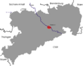
The Free State of Saxony 1945–1952
-
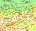
Topographic map of Saxony
-
TU Dresden is the largest university in Saxony.
-
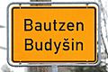
Boundary sign of Bautzen / Budyšin in German and Upper Sorbian. Many place names in eastern Saxony are derived from Sorbian.
-
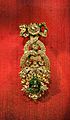
The 'Dresden Green Diamond' - the largest natural green diamond - is part of the collection of the Green Vault.
-
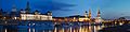
Dresden is one of the most visited cities in Germany and Europe.
-
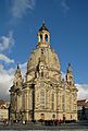
The Dresden Frauenkirche. It now serves as a symbol of reconciliation between former warring enemies.
-
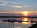
Leipziger Neuseenland is a large lake district south of Leipzig, one of Germany's most vibrant cities.
-
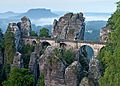
The Bastei bridge in Saxon Switzerland
-
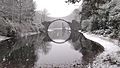
The Rakotz bridge at Azalea and Rhododendron Park Kromlau
-
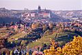
The historical city of Görlitz
-
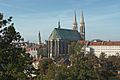
The Elbe valley with Meissen in the background
-
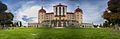
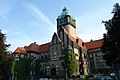
Saxony is home to numerous castles, such as Schloss Moritzburg north of Dresden.
-
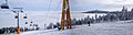
Oberwiesenthal, Ore Mountains


.jpg)


.jpg)


See also
 In Spanish: Sajonia para niños
