Perry County, Illinois facts for kids
Quick facts for kids
Perry County
|
|
|---|---|

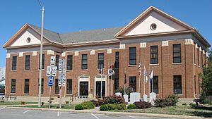
Perry County Courthouse in Pinckneyville
|
|

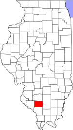
Location within the U.S. state of Illinois
|
|
 Illinois's location within the U.S. |
|
| Country | |
| State | |
| Founded | January 29, 1827 |
| Named for | Oliver Hazard Perry |
| Seat | Pinckneyville |
| Largest city | Du Quoin |
| Area | |
| • Total | 447 sq mi (1,160 km2) |
| • Land | 442 sq mi (1,140 km2) |
| • Water | 5.2 sq mi (13 km2) 1.2% |
| Population
(2020)
|
|
| • Total | 20,945 |
| • Density | 46.86/sq mi (18.092/km2) |
| Time zone | UTC−6 (Central) |
| • Summer (DST) | UTC−5 (CDT) |
| Congressional district | 12th |
Perry County is a county located in the state of Illinois. In 2020, about 20,945 people lived here. Its main town, or county seat, is Pinckneyville. Perry County is found in the southern part of Illinois, an area known as "Little Egypt".
Contents
History of Perry County
Perry County was created in 1827. It was formed from parts of Jackson and Randolph counties. The county was named after Oliver Hazard Perry. He was a naval hero who won an important battle during the War of 1812.
In its early days, Perry County was a pioneer area far from big cities. Early settlers, including some who fought in the American Revolutionary War, moved here from the eastern United States. Most of these first settlers were Protestants.
The county grew quickly in the 1850s for two main reasons. First, the Illinois Central Railroad was built through the eastern part of the county. Second, large amounts of coal were discovered. Many immigrants from countries like Ireland, Poland, Germany, and Italy moved to the county between 1850 and the 1920s. After the American Civil War, African Americans also settled in the county as they moved north.
Mining coal was the main job for many people in Perry County for a long time. This continued to be the most important type of work through the 1990s.
Geography and Landscape
Perry County covers about 447 square miles. Most of this area, about 442 square miles, is land. The remaining 5.2 square miles (1.2%) is water.
The county is in Southern Illinois. Pinckneyville, which is in the middle of the county, is about 70 miles southeast of St. Louis, Missouri. It is also about 300 miles southwest of Chicago. The Mississippi River is only about 10 miles to the west and southwest of the county.
The land in Perry County is mostly flat, but it also has some gently rolling hills. The Little Muddy River forms part of the county's eastern border. Beaucoup Creek flows from north to south through the county, just east of Pinckneyville.
Many lakes in the county are "strip cut" lakes. These lakes were formed after coal was mined from the ground. For example, lakes at the Du Quoin State Fairgrounds and Pyramid State Recreation Area were created this way.
Climate and Weather
| Weather chart for Pinckneyville, Illinois | |||||||||||||||||||||||||||||||||||||||||||||||
|---|---|---|---|---|---|---|---|---|---|---|---|---|---|---|---|---|---|---|---|---|---|---|---|---|---|---|---|---|---|---|---|---|---|---|---|---|---|---|---|---|---|---|---|---|---|---|---|
| J | F | M | A | M | J | J | A | S | O | N | D | ||||||||||||||||||||||||||||||||||||
|
2.8
40
22
|
2.6
46
26
|
4.3
57
36
|
4.3
68
45
|
4.8
77
55
|
4.2
86
64
|
3.5
90
68
|
3.3
88
65
|
3.3
81
57
|
3.2
71
45
|
4.4
56
36
|
3.5
44
26
|
||||||||||||||||||||||||||||||||||||
| temperatures in °F precipitation totals in inches source: The Weather Channel |
|||||||||||||||||||||||||||||||||||||||||||||||
|
Metric conversion
|
|||||||||||||||||||||||||||||||||||||||||||||||
In Pinckneyville, the average temperature in January is about 22°F (low) and 40°F (high). In July, it ranges from about 68°F (low) to 90°F (high). The coldest temperature ever recorded was -22°F in January 1912. The hottest was 113°F in July 1934.
The amount of rain and snow changes throughout the year. February usually has the least precipitation, about 2.61 inches. May typically has the most, about 4.81 inches.
Transportation and Roads
- South Central Transit
- Du Quoin station
Major Highways
 U.S. Route 51
 Illinois Route 4
 Illinois Route 13
 Illinois Route 14
 Illinois Route 127
 Illinois Route 150
 Illinois Route 152
 Illinois Route 154
Neighboring Counties
Perry County shares its borders with several other counties:
- Washington County - to the north
- Jefferson County - to the northeast
- Franklin County - to the east
- Jackson County - to the south
- Randolph County - to the west
Population and People
| Historical population | |||
|---|---|---|---|
| Census | Pop. | %± | |
| 1830 | 1,215 | — | |
| 1840 | 3,222 | 165.2% | |
| 1850 | 5,278 | 63.8% | |
| 1860 | 9,552 | 81.0% | |
| 1870 | 13,723 | 43.7% | |
| 1880 | 16,007 | 16.6% | |
| 1890 | 17,529 | 9.5% | |
| 1900 | 19,830 | 13.1% | |
| 1910 | 22,088 | 11.4% | |
| 1920 | 22,901 | 3.7% | |
| 1930 | 22,767 | −0.6% | |
| 1940 | 23,438 | 2.9% | |
| 1950 | 21,684 | −7.5% | |
| 1960 | 19,184 | −11.5% | |
| 1970 | 19,757 | 3.0% | |
| 1980 | 21,714 | 9.9% | |
| 1990 | 21,412 | −1.4% | |
| 2000 | 23,094 | 7.9% | |
| 2010 | 22,350 | −3.2% | |
| 2020 | 20,945 | −6.3% | |
| 2023 (est.) | 20,503 | −8.3% | |
| U.S. Decennial Census 1790-1960 1900-1990 1990-2000 2010 |
|||
In 2010, there were 22,350 people living in Perry County. There were 8,335 households and 5,622 families. The county had about 50.6 people per square mile.
Most people in the county were white (87.9%). About 8.3% were Black or African American. Other groups included Asian (0.4%) and American Indian (0.2%). About 2.7% of the population was of Hispanic or Latino origin.
Many residents have German (32.8%), Irish (14.3%), English (10.6%), American (8.1%), or Polish (6.3%) backgrounds.
The average age in the county was 39.4 years old. About 30.4% of households had children under 18 living with them. The median income for a household was $40,696. This means half of the households earned more, and half earned less. About 14.0% of the population lived below the poverty line.
Communities in Perry County
Perry County does not use a township system of government. Instead, it is divided into areas called precincts for elections. These precincts are adjusted to make sure each one has a similar number of people.
Cities
Villages
Unincorporated Communities
These are smaller communities that are not officially part of a city or village:
See also
 In Spanish: Condado de Perry (Illinois) para niños
 | William L. Dawson |
 | W. E. B. Du Bois |
 | Harry Belafonte |


