
Jefferson County, Illinois facts for kids
Quick facts for kids
Jefferson County
|
|
|---|---|

Jefferson County Courthouse in Mount Vernon
|
|

Location within the U.S. state of Illinois
|
|
 Illinois's location within the U.S. |
|
| Country | |
| State | |
| Founded | 1819 |
| Named for | Thomas Jefferson |
| Seat | Mount Vernon |
| Largest city | Mount Vernon |
| Area | |
| • Total | 584 sq mi (1,510 km2) |
| • Land | 571 sq mi (1,480 km2) |
| • Water | 13 sq mi (30 km2) 2.2% |
| Population
(2020)
|
|
| • Total | 37,113 |
| • Estimate
(2023)
|
36,320 |
| • Density | 63.55/sq mi (24.537/km2) |
| Time zone | UTC−6 (Central) |
| • Summer (DST) | UTC−5 (CDT) |
| Congressional district | 12th |
Jefferson County is a county in the southern part of Illinois. In 2020, about 37,113 people lived here. The main town and county seat is Mount Vernon. This county is part of the Mount Vernon, Illinois micropolitan area. It is also in a southern area of Illinois known as "Little Egypt". The western edge of the county is close to the bigger Greater St. Louis area.
Contents
History of Jefferson County
The first person believed to have settled in Jefferson County was Andrew Moore. In 1810, he made his home near the southeast corner of the county. This was close to where the Goshen Road came out of the forest in Hamilton County. This area is now called Moore's Prairie. Andrew Moore came from the Goshen Settlement, which was near Edwardsville. This means he traveled from the west towards the middle of the state.
In 1814, Andrew Moore and his eight-year-old son left for Jordan's settlement. They never came back from this trip. Several years later, a skull believed to be Moore's was found about two miles from his cabin. Jordan's Settlement, also called Jordan's Fort, was southeast of modern Thompsonville, Illinois. This was about twenty miles south of Moore's cabin. This happened during the War of 1812, when many Native American tribes were working with the British.
In 1816, Carter Wilkey, Daniel Crenshaw, and Robert Cook settled in Moore's Prairie. Daniel Crenshaw moved into Moore's old cabin. People believe this was the first lasting settlement in the county.
Jefferson County was officially created in 1819. It was formed from parts of White, Edwards, and Franklin Counties. The county was named after Thomas Jefferson. He was a very important person who helped write the Northwest Ordinance. The northern border of the county crosses the Third Principal Meridian at its northwest corner.
-
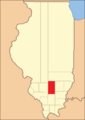
Jefferson County between 1819 and 1821
-
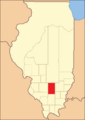
Jefferson County between 1821 and 1823
-
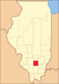
Jefferson County in 1823, showing its current size


Geography of Jefferson County
The U.S. Census Bureau says the county covers a total area of 584 square miles. Out of this, 571 square miles is land, and 13 square miles (2.2%) is water.
Climate and Weather
| Weather chart for Mount Vernon, Illinois | |||||||||||||||||||||||||||||||||||||||||||||||
|---|---|---|---|---|---|---|---|---|---|---|---|---|---|---|---|---|---|---|---|---|---|---|---|---|---|---|---|---|---|---|---|---|---|---|---|---|---|---|---|---|---|---|---|---|---|---|---|
| J | F | M | A | M | J | J | A | S | O | N | D | ||||||||||||||||||||||||||||||||||||
|
2.5
37
19
|
2.7
43
23
|
4
54
33
|
4.4
65
43
|
4.6
75
53
|
3.6
84
62
|
3.6
88
66
|
3.3
86
64
|
3.1
79
56
|
2.9
68
43
|
4.4
54
34
|
3.2
42
24
|
||||||||||||||||||||||||||||||||||||
| temperatures in °F precipitation totals in inches source: The Weather Channel |
|||||||||||||||||||||||||||||||||||||||||||||||
|
Metric conversion
|
|||||||||||||||||||||||||||||||||||||||||||||||
In recent years, the average temperatures in Mount Vernon, the county seat, have changed a lot. In January, the average low is 19°F. In July, the average high is 88°F. The coldest temperature ever recorded was -21°F in January 1994. The hottest was 114°F in July 1936. The average rainfall each month ranges from 2.45 inches in January to 4.58 inches in May.
Major Roads
 Interstate 57
 Interstate 64
 U.S. Highway 51
 Illinois Route 15
 Illinois Route 37
 Illinois Route 142
 Illinois Route 148
Public Transportation
- South Central Transit
- List of intercity bus stops in Illinois
Neighboring Counties
- Marion County – to the north
- Wayne County – to the northeast
- Hamilton County – to the southeast
- Franklin County – to the south
- Perry County – to the southwest
- Washington County – to the west
Population Information
| Historical population | |||
|---|---|---|---|
| Census | Pop. | %± | |
| 1820 | 691 | — | |
| 1830 | 2,555 | 269.8% | |
| 1840 | 5,762 | 125.5% | |
| 1850 | 8,109 | 40.7% | |
| 1860 | 12,965 | 59.9% | |
| 1870 | 17,864 | 37.8% | |
| 1880 | 20,686 | 15.8% | |
| 1890 | 22,590 | 9.2% | |
| 1900 | 28,133 | 24.5% | |
| 1910 | 29,111 | 3.5% | |
| 1920 | 28,480 | −2.2% | |
| 1930 | 31,034 | 9.0% | |
| 1940 | 34,375 | 10.8% | |
| 1950 | 35,892 | 4.4% | |
| 1960 | 32,315 | −10.0% | |
| 1970 | 31,446 | −2.7% | |
| 1980 | 36,552 | 16.2% | |
| 1990 | 37,020 | 1.3% | |
| 2000 | 40,045 | 8.2% | |
| 2010 | 38,827 | −3.0% | |
| 2020 | 37,113 | −4.4% | |
| 2023 (est.) | 36,320 | −6.5% | |
| U.S. Decennial Census 1790–1960 1900–1990 1990–2000 2010–2013 |
|||

In 2010, there were 38,827 people living in Jefferson County. There were 15,365 households, which are groups of people living together. The population density was about 68 people per square mile. Most people (88.4%) were white, and 8.4% were black or African American. About 2.1% of the people were of Hispanic or Latino background.
Many families had children under 18 living with them (30.1%). About half of the households (50.0%) were married couples. The average age of people in the county was 40.6 years old.
The average yearly income for a household was $41,161. For families, it was $51,262. About 17.1% of all people in the county lived below the poverty line. This means they had a very low income.
Local Government and Services
In 2015, the county police department announced that the words "In God We Trust" would be placed on police cars. Jeff Bullard is currently the Sheriff of Jefferson County. The Sheriff is the chief law enforcement officer in the county.
Towns and Villages
Cities
Villages
Other Places
- Opdyke (a census-designated place)
Small Communities
Townships
Jefferson County is divided into sixteen local government areas called townships:
- Bald Hill
- Blissville
- Casner
- Dodds
- Elk Prairie
- Farrington
- Field
- Grand Prairie
- McClellan
- Moore's Prairie
- Mt. Vernon
- Pendleton
- Rome
- Shiloh
- Spring Garden
- Webber
Education
Here are the school districts in Jefferson County:
Schools for All Grades (K-12)
- Bluford Unit School District 318
- Hamilton County Community Unit School District 10
- Sesser-Valier Community Unit School District 196
- Waltonville Community Unit School District 1
- Wayne City Community Unit School District 100
- Woodlawn Unit District 209
High Schools
- Benton Consolidated High School District 103
- Centralia High School District 200
- Mount Vernon Township High School District 201
- Nashville Community High School District 99
- Salem Community High School District 600
Elementary Schools
- Ashley Community Consolidated School District 15
- Bethel School District 82
- Centralia School District 135
- Ewing Northern Community Consolidated District 115
- Farrington Community Consolidated School District 99
- Field Community Consolidated School District 3
- Grand Prairie Community Consolidated School District 6
- Kell Consolidated School District 2
- McClellan Community Consolidated School District 12
- Mount Vernon School District 80
- Opdyke-Belle Rive Community Consolidated School District 5
- Spring Garden Community Consolidated School District 178
- Rome Community Consolidated School District 2
- Summersville School District 79
See also
 In Spanish: Condado de Jefferson (Illinois) para niños
