Thompsonville, Illinois facts for kids
Quick facts for kids
Thompsonville, Illinois
|
|
|---|---|

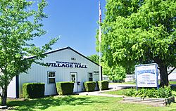
Village Hall
|
|

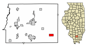
Location of Thompsonville in Franklin County, Illinois.
|
|

Location of Illinois in the United States
|
|
| Country | United States |
| State | Illinois |
| County | Franklin |
| Township | Cave |
| Area | |
| • Total | 2.05 sq mi (5.30 km2) |
| • Land | 2.03 sq mi (5.26 km2) |
| • Water | 0.02 sq mi (0.04 km2) |
| Elevation | 502 ft (153 m) |
| Population
(2020)
|
|
| • Total | 486 |
| • Density | 239.29/sq mi (92.40/km2) |
| Time zone | UTC-6 (CST) |
| • Summer (DST) | UTC-5 (CDT) |
| ZIP Code(s) |
62890
|
| Area code(s) | 618 |
| FIPS code | 17-75159 |
| GNIS feature ID | 419677 |
| Wikimedia Commons | Thompsonville, Illinois |
Thompsonville is a small village located in Franklin County, Illinois, in the United States. It is part of Cave Township. According to the 2020 census, about 486 people live in Thompsonville.
Contents
Village History
An early settlement, or small community, was started nearby in 1811. It was known as "Jordan's Settlement."
Thompsonville's Location and Size
Thompsonville is found in the southeastern part of Franklin County. Its exact location is 37°54′59″N 88°45′42″W / 37.91639°N 88.76167°W.
Illinois Route 34 goes through the village. This road leads northwest about 10 miles (16 km) to Benton, which is the main town of the county. It also goes southeast about 21 miles (34 km) to Harrisburg. Another road, Illinois Route 149, goes west from Thompsonville about 9 miles (14 km) to West Frankfort.
The village covers a total area of about 2.05 square miles (5.31 square kilometers). Most of this area, about 2.03 square miles (5.26 square kilometers), is land. A very small part, about 0.02 square miles (0.05 square kilometers), is water.
Population Information
| Historical population | |||
|---|---|---|---|
| Census | Pop. | %± | |
| 1880 | 172 | — | |
| 1890 | 309 | 79.7% | |
| 1900 | 398 | 28.8% | |
| 1910 | 573 | 44.0% | |
| 1920 | 577 | 0.7% | |
| 1930 | 569 | −1.4% | |
| 1940 | 568 | −0.2% | |
| 1950 | 530 | −6.7% | |
| 1960 | 428 | −19.2% | |
| 1970 | 449 | 4.9% | |
| 1980 | 610 | 35.9% | |
| 1990 | 602 | −1.3% | |
| 2000 | 571 | −5.1% | |
| 2010 | 543 | −4.9% | |
| 2020 | 486 | −10.5% | |
| U.S. Decennial Census | |||
In 2020, the census counted 486 people living in Thompsonville. There were 220 households, which means 220 different homes or groups of people living together. About 112 of these were families.
The population density was about 237 people for every square mile (92 people per square kilometer). This tells us how many people live in a certain amount of space. There were also 261 housing units, which are places where people can live.
Most of the people in Thompsonville are White (94.44%). A small number of people are from other racial backgrounds, including African American, Native American, and Asian. About 1.03% of the population identified as Hispanic or Latino.
Age Groups in Thompsonville
The people living in Thompsonville are of different ages:
- About 29.6% of the population was under 18 years old.
- About 11.6% were between 18 and 24 years old.
- About 17.4% were between 25 and 44 years old.
- About 18.4% were between 45 and 64 years old.
- About 23.0% were 65 years old or older.
The average age of people in the village was 36.5 years.
See also
 In Spanish: Thompsonville (Illinois) para niños
 | DeHart Hubbard |
 | Wilma Rudolph |
 | Jesse Owens |
 | Jackie Joyner-Kersee |
 | Major Taylor |

