Belle Rive, Illinois facts for kids
Quick facts for kids
Belle Rive, Illinois
|
|
|---|---|

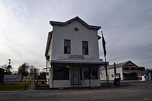
Belle Rive post office, December 2019
|
|

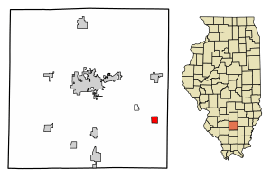
Location of Belle Rive in Jefferson County, Illinois
|
|

Location of Illinois in the United States
|
|
| Country | United States |
| State | Illinois |
| County | Jefferson |
| Township | Pendleton |
| Area | |
| • Total | 1.03 sq mi (2.66 km2) |
| • Land | 1.03 sq mi (2.66 km2) |
| • Water | 0.00 sq mi (0.00 km2) |
| Elevation | 476 ft (145 m) |
| Population
(2020)
|
|
| • Total | 309 |
| • Density | 301.17/sq mi (116.27/km2) |
| Time zone | UTC-6 (CST) |
| • Summer (DST) | UTC-5 (CDT) |
| ZIP code |
62810
|
| Area code(s) | 618 |
| FIPS code | 17-04806 |
| GNIS ID | 2398076 |
| Wikimedia Commons | Belle Rive, Illinois |
Belle Rive is a small village located in Jefferson County, Illinois, in the United States. In 2020, about 309 people lived there. It is part of the larger Mount Vernon area.
Contents
History of Belle Rive
Early Beginnings in 1852
Back in 1852, a rich land buyer named Edmund P. Grant purchased a large area of land. This land was around where Belle Rive is today. Grant was hoping a new railroad would be built through the area. He wanted to create a town there.
Railroad Plans and Changes
However, the first plan to build a railroad failed. This happened during a time when the economy was not doing well. Edmund Grant later left the area in 1863 due to disagreements.
Founding of the Village
Belle Rive was officially started in 1871. This happened at the same time a new railroad, the St. Louis & Southeastern Railroad, opened. The village was named after Louis Groston de Saint-Ange de Bellerive. He was a historical figure who gave control of Illinois to the British in 1765.
Geography of Belle Rive
Location and Nearby Towns
Belle Rive is in the southeastern part of Jefferson County. Illinois Route 142 is a main road that goes through the village. This road leads northwest about 11 miles to Mount Vernon. Mount Vernon is the main city and county seat of Jefferson County. The road also goes southeast about 15 miles to McLeansboro.
Land and Water
According to the 2010 census, Belle Rive covers about 0.87 square miles (2.25 square kilometers). All of this area is land. The village's water flows into Auxier Creek. This creek then flows into the Little Wabash River. This whole system is called a watershed.
Population of Belle Rive
| Historical population | |||
|---|---|---|---|
| Census | Pop. | %± | |
| 1900 | 370 | — | |
| 1910 | 312 | −15.7% | |
| 1920 | 311 | −0.3% | |
| 1930 | 278 | −10.6% | |
| 1940 | 333 | 19.8% | |
| 1950 | 313 | −6.0% | |
| 1960 | 303 | −3.2% | |
| 1970 | 279 | −7.9% | |
| 1980 | 401 | 43.7% | |
| 1990 | 396 | −1.2% | |
| 2000 | 371 | −6.3% | |
| 2010 | 361 | −2.7% | |
| 2020 | 309 | −14.4% | |
| U.S. Decennial Census | |||
The population of Belle Rive has changed over the years. In 2000, there were 371 people living in the village. By 2010, the population was 361. The most recent count in 2020 showed 309 people living in Belle Rive. The average age of people in the village in 2000 was 41 years old.
See also
 In Spanish: Belle Rive para niños
 | Stephanie Wilson |
 | Charles Bolden |
 | Ronald McNair |
 | Frederick D. Gregory |

