
Carrier Mills, Illinois facts for kids
Quick facts for kids
Carrier Mills
Morrilsville
|
|
|---|---|
|
Village
|
|

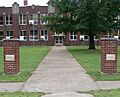
From the high school facing north toward downtown.
|
|
| Nicknames:
Catskin, The Mills, CMills, "With an s on both ends."
|
|
| Motto(s):
Where A Friendly Smile Says Stay Awhile
|
|

Location of Carrier Mills in Saline County, Illinois.
|
|
.svg)
Location of Illinois in the United States
|
|
| Country | United States |
| State | Illinois |
| County | Saline |
| Founded | 1872 |
| Area | |
| • Total | 1.22 sq mi (3.15 km2) |
| • Land | 1.21 sq mi (3.13 km2) |
| • Water | 0.01 sq mi (0.03 km2) |
| Population
(2020)
|
|
| • Total | 1,672 |
| • Density | 1,384.11/sq mi (534.50/km2) |
| Time zone | UTC-6 (CST) |
| • Summer (DST) | UTC-5 (CDT) |
| ZIP code |
62917
|
| Area code(s) | Area code 618 |
| FIPS code | 17-11397 |
Carrier Mills is a small village in Saline County, Illinois, United States. It was once called Carrier's Mills and Morrilsville. People also know it by the nickname Catskin. In 2020, about 1,672 people lived there.
The village got its name from George Washington Carrier's saw and grist mills. It was one of the first "boomtowns" along the Cairo and Vincennes Railroad. Carrier Mills started as a place for mills, then became a coal mining town. Over time, its population has gone down by 44% since the 1920s, mostly because the local coal mines closed.
Today, Carrier Mills is mainly a "bedroom community." This means many people who live there travel to nearby Harrisburg for work, fun, and shopping. It's the third-largest community in the Harrisburg area. Carrier Mills also has a large African American population, about 15% of its residents. This is partly because people moved there from Lakeview, which is the oldest African American settlement in Illinois.
Every October, the village hosts the annual Catskin Days Fair and Parade. This multi-day festival celebrates the village's history and culture.
Contents
History of Carrier Mills
The first person to settle in the area that became Carrier Mills was Hampton Pankey. He arrived around 1804 or 1805. Around 1811, settlers built strong blockhouses to protect themselves from American Indians. One of these was on Pankey's land. His son, John Pankey, later helped found the city of Harrisburg.
In November 1872, Benjamin D Lewis surveyed the village for William Housely. It was first called Morrillsville, named after H. L. Morrill. He was the superintendent of the Cairo and Vincennes Railroad and made a land deal with mill owner G. W. Carrier.
The town was commonly known as Carrier's Mills. It was later officially renamed after G. Washington Carrier, also known as "Uncle Wash." He helped start the town by building a large steam-powered saw mill and a grist mill. These mills were just south of town on the Saline River. At that time, cypress trees grew as far north as Carrier's Mills, making lumber production very profitable. The mills first made lumber for railroad bridges and ties. Later, they provided wood for the town's businesses and homes.
Carrier and Morrill agreed to build a train depot in the area. The town was planned right next to the new Cairo and Vincennes Railroad. In 1873, the first postmaster was assigned to Carrier's Mills. The town's name changed to "Carrier Mills" when more woodworking factories were built. The village officially became a town on September 18, 1894. After the Civil War, many settlers moved from the south, and the small village grew quickly.
In the early days, Carrier Mills didn't have brick buildings, and sidewalks were made of wood. The main business area was on Oak Street. In February 1908, a big fire destroyed all the buildings on the north side of Oak Street. The next month, another fire burned most buildings on the south side. Business owners quickly rebuilt everything using brick.
The Tuller Mansion, also called "Tuller Place," was a beautiful Victorian house built in 1910. It was made of red brick and had two stories. Inside, it featured a grand staircase with marble floors, fancy bathtubs, and fine mahogany wood. The mansion was built by Arthur V. Tuller, who was related to George Washington Carrier. Sadly, the house burned down in the 1990s.
After the lumber business slowed down, Coal mining became very important to Carrier Mills. Over 100 coal mines operated around the village from the early 1900s to the late 1990s. From 1913 to 1933, a trolley line connected Carrier Mills to Harrisburg. During its busiest time, about 3,000 people lived and worked in the town. When the coal mines closed, the population dropped to around 1,500. This made Carrier Mills almost a ghost town. In 2009, Carrier Mills ended a 70-year ban on alcohol sales. On February 29, 2012, a very strong tornado touched down just north of Carrier Mills. It destroyed a church and damaged homes before moving towards Harrisburg.
Local School History
The very first school in Carrier Mills was a large, two-story wooden building with a bell tower. It was built in the early 1820s. This early school was made of logs and had a clay chimney. The school year was short, from August to October, because of the cold weather. By 1850, many schools were "subscription schools," where families paid a fee for their children to attend.
In 1887, the first school building within Carrier Mills Village was bought for a subscription school. The first major public school opened in 1903. In 1915, the first two-year high school course began. By 1926, the high school became a fully recognized community high school, approved by the state of Illinois.
Around 1940, the Carrier Mills Public School building caught fire during a Boy Scout meeting. A much larger grade school was built a year later, using the frame of the old burnt school. On February 4, 1938, the current High School building was finished. A gymnasium and auditorium were added in 1940, and the gym was made even bigger in 1950–51. In 1963, the small town of Stonefort joined the Carrier Mills school district, creating the Carrier Mills-Stonefort Unit 2 School District.
Downtown Changes
The main business area of Carrier Mills used to be a busy place. It stretched along Main Street, Oak Street, and Railroad Street. However, by July 2006, much of the downtown area was torn down because the buildings were old and unsafe. Many citizens felt sad but agreed it was better to have empty lots than decaying buildings.
The decline of the downtown area happened slowly over about 25 years. It wasn't just one event. For example, the Will Scarlet Mine closed in 1987, and Sahara's mines closed in 1993. These closures meant hundreds of people lost their jobs. Sahara used to buy many things locally, so when they stopped, it hurt local businesses a lot. But the downtown area was already declining even before these big mine closures.
In its best days, Carrier Mills had several hotels, two movie theaters (The Knox and the Grand Theater), two banks, and many stores and markets. Most of these have been torn down or burned over the last 20 years. There were also small grocery stores in many neighborhoods. These small stores closed as more people owned cars and could drive to bigger stores. This trend contributed to the decline of many small towns like Carrier Mills.
In July 2006, new rules were made for building in the empty downtown area. The mayor wanted the town to look nice and not like a farm. In April 2007, the village board approved a plan to create a special district to attract new homeowners and businesses. This plan aimed to improve the quality of life by encouraging new houses and fixing old ones. In June 2011, the two-story Field and Dime Store building collapsed due to its poor condition. It was one of only four original downtown buildings left.
Lakeview (Pond Settlement)
Carrier Mills has a rich African American history. Free black people founded the small settlement of Lakeview, about a mile south of Carrier Mills, shortly after the War of 1812. This community is older than Carrier Mills itself. It is known as the oldest black settlement in Illinois. It was first called Pond Settlement because of the swampy land around it. Local stories say that free black residents in Pond Settlement helped runaway slaves escape from nearby salt works and the Old Slave House.
Lakeview had its own school, grocery store, and many homes. In 1850, a Union Church was started. Later, an African Methodist Episcopal Church was organized and built a log church. After that church burned, the community rebuilt it and moved it to Carrier Mills, where it is now Baber Chapel AME Church. The Lakeview cemetery is now a state historical landmark. Even today, the Lakeview area is mostly black. After the Lakeview school closed in the 1950s, many people moved to the east side of Carrier Mills, which locals call "East End."
In 2022, a plan was submitted to make Lakeview a federal historical designation district. In 2023, the Illinois Department of Natural Resources received a grant to recognize important African American heritage sites in southern Illinois. This project will help add the African American history of Pond Settlement (Lakeview) to the Carrier Mills Archaeological District.
Carrier Mills Archaeological District
The Carrier Mills Archaeological District is an area of about 143 acres (0.58 square kilometers) located two miles south of Carrier Mills. This area was home to prehistoric people during three different time periods. Before the 1900s, the South Fork of the Saline River had many swamps and shallow cypress lakes. These areas were full of plants and animals that ancient people used for food. Because of this, the area was a great place for people to settle. In 1978 and 1979, archaeologists carefully studied this area. They found many tools, animal bones, and plant remains. These discoveries have taught us a lot about the history of southern Illinois.
Small groups of hunters and gatherers used the area as early as 8000 BC. People lived there on and off until about 1400 AD. More people started living there during the late Middle Archaic Period, from 4500 to 3000 BC. These groups were larger and lived a more settled life. They left behind many artifacts and burials. The area was also used a lot during the Middle and Late Woodland periods, from 200 BC to 900 AD. People during these times started collecting and storing more plant foods and even began to grow some native plants. The last prehistoric people to live there were the Mississippian Period Indians (900 to 1400 AD). They lived in scattered farmhouses and grew corn and squash.
Catskin Days
Carrier Mills earned the nickname "Catskin" for two reasons. First, there used to be many stray cats in town. Second, there's a story from the late 1800s about a store owner named Wes Cole. Local kids tricked him into thinking a skinned cat hide was a valuable mink fur. They traded it for a jug of whiskey.
To this day, the village celebrates its history and culture with the annual Catskin Days Fair and Parade. This multi-day festival takes place in October. The local school's mascot is also the Wildcat, linking back to this unique nickname.
Geography
Carrier Mills is located at 37°41′13″N 88°37′45″W / 37.68694°N 88.62917°W.
According to the 2010 census, Carrier Mills covers about 1.22 square miles (3.16 square kilometers). Most of this area, about 1.21 square miles (3.13 square kilometers), is land. Only a small part, about 0.011 square miles (0.03 square kilometers), is water.
The village sits on a hillside that has many old underground mines. This hillside looks over a flat area to the south, where the community of Lakeview was built. This flat area is swampy and drained by the South Fork of the Saline River. In the distance, you can see two ridges of the Shawnee Hills, which often look blue.
Carrier Mills is divided into two main parts. Washington Street is the only major road that connects these two sections from east to west. Between the two parts is the raised bed of the old New York Central Railroad, which is now the Tunnel Hill State Trail. There's also the old streetcar bypass on Carline Street, which cuts through the village from southwest to northeast. The downtown area is in the southwest corner. The largest part of the village is to the northwest, and the "East End" is to the southeast. US Route 45 runs along the southern edge, giving Carrier Mills its unique 'L' shape.
Demographics
| Historical population | |||
|---|---|---|---|
| Census | Pop. | %± | |
| 1900 | 427 | — | |
| 1910 | 1,558 | 264.9% | |
| 1920 | 3,000 | 92.6% | |
| 1930 | 2,140 | −28.7% | |
| 1940 | 2,360 | 10.3% | |
| 1950 | 2,252 | −4.6% | |
| 1960 | 2,006 | −10.9% | |
| 1970 | 2,013 | 0.3% | |
| 1980 | 2,268 | 12.7% | |
| 1990 | 1,991 | −12.2% | |
| 2000 | 1,886 | −5.3% | |
| 2010 | 1,655 | −12.2% | |
| 2020 | 1,672 | 1.0% | |
| Decennial US Census | |||
In 2010, there were 1,653 people living in Carrier Mills. There were 744 households, and 463 of these were families. The village had about 1,523 people per square mile (588 people per square kilometer). There were 866 housing units.
Most of the people in the village were White (86.6%). About 14.8% were African American. A small number were Native American (0.5%), Asian (0.4%), or from other backgrounds. About 0.9% of the population was Hispanic or Latino.
In terms of households, 25.7% had children under 18. About 43.4% were married couples living together. About 15.1% had a female head of household with no husband present. And 37.8% were not families. About 34.0% of all households were single individuals, and 16.1% had someone living alone who was 65 years old or older. The average household had 2.22 people, and the average family had 2.80 people.
The population was spread out by age:
- 21.2% were under 18 years old.
- 8.9% were aged 18 to 24.
- 23.2% were aged 25 to 44.
- 22.6% were aged 45 to 64.
- 24.0% were 65 years or older.
The average age was 42 years. For every 100 females, there were about 84.5 males.
The median household income was $25,493, and the median family income was $35,037. This means half of the households earned more than this amount, and half earned less. For males, the median income was $31,458, while for females it was $16,756. The per capita income for the village was $14,314. About 13.2% of families and 17.7% of the total population lived below the poverty line. This included 23.4% of those under 18 and 16.7% of those aged 65 or over.
Images for kids
-
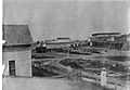
Earliest known photo of Downtown Carrier Mills from Walnut Street, 1905.
-
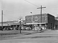
Downtown Carrier Mills in 1939.
-
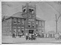
First Carrier Mills Public School in 1905. This building burned and was rebuilt in 1938.
-
Carrier Mills High School, erected 1940.
-
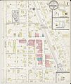
Carrier Mills traditional business district with listed buildings, 1914.
-
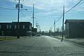
The town's once heavily traveled Main Street (looking south from Baptist Church) by 2006 had been reduced to just a few buildings.


See also
 In Spanish: Carrier Mills (Illinois) para niños
