Saline River (Illinois) facts for kids
Quick facts for kids Saline River (Illinois) |
|
|---|---|

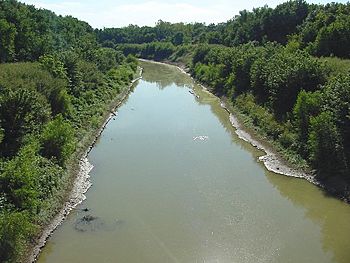
The Saline River.
|
|
| Country | United States |
| State | Illinois |
| Physical characteristics | |
| Main source | Brushy Creek (Saline River) Williamson County, Illinois, United States 351 ft (107 m) |
| River mouth | Ohio River Saline Landing, Illinois, United States 200 ft (61 m) |
| Basin features | |
| Basin size | 1,762 sq mi (4,560 km2) |
The Saline River is a river in Southern Illinois, United States. It flows into the Ohio River and is about 27 miles (43 km) long. The river helps drain a large area of southeast Illinois, covering about 1,762 square miles (4,560 km2). Its main branches are the South Fork, Middle Fork, and North Fork. These all flow through the Saline Valley. Long ago, this swampy river was very important to Native Americans and early settlers. They used it to get salt from many salt springs nearby. Salt was a valuable resource and was collected here in the early 1800s.
Contents
A Look Back: The Saline River's History
The Saline River played a big role in Illinois's early economy. Between 1807 and 1818, Illinois made a lot of money from its salt industry. This income was much higher than what other nearby states earned from similar activities. A significant part of Illinois's state money came from the salt collected along the Saline River.
Salt Production and River Use
The salt industry was very important in this area. One of the last people to manage the salt springs was John Crenshaw. He owned a place that later became known as the Old Slave House.
In the late 1700s, many boats traveled on the Saline River. These boats, like keel boats and batteaux, could go about 30 miles (48 km) inland from the Ohio River. The city of Harrisburg, Illinois was the farthest point west where larger flat boats could still travel. However, the river has not been used for boats in nearly a century. Today, it mostly helps with drainage and flood control.
Changes to the River
Work to straighten and deepen the river began in 1930. This was done to help with water flow. In 1888, a law from 1849 that said the Saline River was open for boats was canceled. This happened because people in the area wanted to build bridges over the river. Building bridges was difficult if the river was still used for large boats.
Exploring the Saline River Watershed
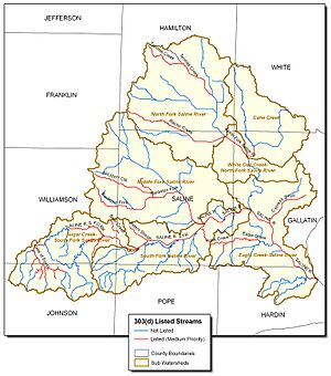
A watershed is an area of land where all the water drains into one main river or lake. The main part of the Saline River is about 26.9 miles (43.3 km) long. It drains a huge area of about 1,128,300 acres (4,566 km2). The river starts where the South Fork and Middle Fork rivers meet, east of Harrisburg, Illinois.
The River's Branches
- The South Fork is about 49.2 miles (79.2 km) long. It begins in northern Johnson County, near the Lake of Egypt.
- The Middle Fork is about 24.9 miles (40.1 km) long. It starts in southwestern Hamilton County.
- The North Fork is about 33.7 miles (54.2 km) long. It joins the main river east of Equality, Illinois. It starts in central Hamilton County, southeast of McLeansboro, Illinois.
Water Quality and Environment
In 1995, the water quality in the Saline River was rated as "Fair" to "Good." However, there are some pollution issues. These include things like too many nutrients, dirt getting into the water, and changes to the river's natural shape. These problems often come from farm runoff, changes made to the river for flood control, and mining.
The North and Middle forks of the Saline River have fewer Indiana crayfish than they used to. This is because of water pollution, coal mining, oil drilling, and changes to the river's path.
The Saline River watershed is in southern Illinois. It flows east and covers over 754,942 acres (3,055.14 km2). This area includes parts of several counties: Hamilton, White, Franklin, Williamson, Gallatin, Johnson, Pope, Hardin, and Saline Counties.
Landscape and Communities
The land in the watershed is mostly farms. It has many small streams, creeks, and human-made lakes that flow into the Saline River. The river then empties into the Ohio River, which is about 450 feet (140 m) wide at that point. The Lake of Egypt is the largest lake in the watershed. It covers about 2,300 acres (9.3 km2) and is located on the upper part of the South Fork Saline River.
Most of the people in the watershed live in rural areas. However, there are also many small cities and villages. The river also flows through the eastern part of the Shawnee National Forest. The biggest towns are Harrisburg (with about 9,628 people), Eldorado (4,416 people), McLeansboro (2,945 people), and Carrier Mills (1,886 people). The main jobs in this area are farming, mining, and manufacturing. The cities of Equality and Harrisburg, Illinois were built on high sandstone cliffs overlooking the Middle Fork Valley of the Saline River.
Cities and Counties Along the Saline River
The Saline River and its branches drain water from many cities and counties.
Cities Drained by the South Fork
Cities Drained by the Middle Fork
Cities Drained by the North Fork
Counties in the Watershed
The Saline River watershed includes all or part of these counties:
 | Sharif Bey |
 | Hale Woodruff |
 | Richmond Barthé |
 | Purvis Young |


