
Gallatin County, Illinois facts for kids
Quick facts for kids
Gallatin County
|
|
|---|---|

Gallatin County Courthouse in Shawneetown
|
|

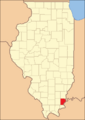
Location within the U.S. state of Illinois
|
|
 Illinois's location within the U.S. |
|
| Country | |
| State | |
| Founded | 1812 |
| Named for | Albert Gallatin |
| Seat | Shawneetown |
| Largest city | Shawneetown |
| Area | |
| • Total | 328 sq mi (850 km2) |
| • Land | 323 sq mi (840 km2) |
| • Water | 5.1 sq mi (13 km2) 1.6% |
| Population
(2020)
|
|
| • Total | 4,946 |
| • Estimate
(2023)
|
4,670 |
| • Density | 15.079/sq mi (5.822/km2) |
| Time zone | UTC−6 (Central) |
| • Summer (DST) | UTC−5 (CDT) |
| Congressional district | 12th |
Gallatin County is a county located in the U.S. state of Illinois. In 2020, about 4,946 people lived there. This makes it the third smallest county in Illinois by population. Its main town, or county seat, is Shawneetown.
Gallatin County is in the southern part of Illinois, an area sometimes called Little Egypt. It's also where the Wabash River meets the Ohio River. This spot, along with nearby counties in Indiana and Kentucky, forms a special three-state meeting point.
Contents
History of Gallatin County
Long ago, making salt was the first big industry in Illinois. Native Americans and later the French started saltworks at the Great Salt Spring. This spring is on the south side of the Saline River, near Equality.
Around 1803, more saltworks were built at Half Moon Lick, also near Equality. Today, the Great Salt Springs are part of the Shawnee National Forest. You can find them about a mile west of the Saline River bridge on Salt Well Road.
Gallatin County was officially created in 1812. It was formed from land that used to be part of Randolph County. The county was named after Albert Gallatin, who was an important government official called the Secretary of the Treasury at that time.
The very first bank in Illinois was in Shawneetown. It was originally in the John Marshall House. This building has been rebuilt and is now a museum for the Gallatin County Historical Society. Don't confuse it with the State Bank of Illinois building. That's another historic site just a block away in Old Shawneetown.
-
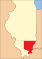
Gallatin County when it was first created in the Illinois Territory (1812-1815)
-
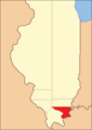
Gallatin County between 1815 and 1816
-
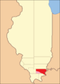
Gallatin County between 1816 and 1818, including extra land
-
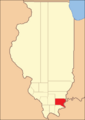
Gallatin County between 1818 and 1847
-
Gallatin County in 1847, after some land was given to Hardin and Saline counties


Geography and Nature
Gallatin County covers a total area of about 328 square miles. Most of this, about 323 square miles, is land. The remaining 5.1 square miles, or 1.6%, is water.
The Wabash River and Ohio River meet in the northeastern part of the county. The Saline River is also a big river in the county, and it flows into the Ohio River.
Climate and Weather in Gallatin County
| Weather chart for Shawneetown, Illinois | |||||||||||||||||||||||||||||||||||||||||||||||
|---|---|---|---|---|---|---|---|---|---|---|---|---|---|---|---|---|---|---|---|---|---|---|---|---|---|---|---|---|---|---|---|---|---|---|---|---|---|---|---|---|---|---|---|---|---|---|---|
| J | F | M | A | M | J | J | A | S | O | N | D | ||||||||||||||||||||||||||||||||||||
|
3.5
41
21
|
3.7
47
24
|
4.7
57
33
|
4.8
68
42
|
5
76
52
|
4.2
84
60
|
4.2
87
65
|
3.5
87
63
|
3.2
80
55
|
3.2
70
43
|
4.4
57
34
|
4.3
46
25
|
||||||||||||||||||||||||||||||||||||
| temperatures in °F precipitation totals in inches source: The Weather Channel |
|||||||||||||||||||||||||||||||||||||||||||||||
|
Metric conversion
|
|||||||||||||||||||||||||||||||||||||||||||||||
In Shawneetown, the county seat, average temperatures change throughout the year. In January, it's usually around 21°F (about -6°C). In July, it's warmer, around 87°F (about 31°C).
The coldest temperature ever recorded was -22°F (about -30°C) in January 1994. The hottest was 104°F (about 40°C) in August 2007. The county gets the most rain in May and the least in October.
Getting Around: Transit and Highways
- Rides Mass Transit District
Major Roads in Gallatin County
 U.S. Highway 45
 Illinois Route 1
 Illinois Route 13
 Illinois Route 141
 Illinois Route 142
Neighboring Counties
Gallatin County shares borders with several other counties:
- White County - to the north
- Posey County, Indiana - to the northeast
- Union County, Kentucky - to the east
- Hardin County - to the south
- Saline County - to the west
- Hamilton County - to the northwest
Protected Natural Areas
Part of the Shawnee National Forest is located within Gallatin County. This is a large protected area with lots of nature to explore.
People of Gallatin County: Demographics
| Historical population | |||
|---|---|---|---|
| Census | Pop. | %± | |
| 1820 | 3,155 | — | |
| 1830 | 7,405 | 134.7% | |
| 1840 | 10,760 | 45.3% | |
| 1850 | 5,448 | −49.4% | |
| 1860 | 8,055 | 47.9% | |
| 1870 | 11,134 | 38.2% | |
| 1880 | 12,861 | 15.5% | |
| 1890 | 14,935 | 16.1% | |
| 1900 | 15,836 | 6.0% | |
| 1910 | 14,628 | −7.6% | |
| 1920 | 12,856 | −12.1% | |
| 1930 | 10,091 | −21.5% | |
| 1940 | 11,414 | 13.1% | |
| 1950 | 9,818 | −14.0% | |
| 1960 | 7,638 | −22.2% | |
| 1970 | 7,418 | −2.9% | |
| 1980 | 7,590 | 2.3% | |
| 1990 | 6,909 | −9.0% | |
| 2000 | 6,445 | −6.7% | |
| 2010 | 5,589 | −13.3% | |
| 2020 | 4,946 | −11.5% | |
| 2023 (est.) | 4,670 | −16.4% | |
| U.S. Decennial Census 1790-1960 1900-1990 1990-2000 2010-2017 |
|||
In 2020, there were 4,946 people living in Gallatin County. There were 2,155 households and 3,764 families.
Most people in the county (about 95%) were white. A smaller number were American Indian, Black or African American, or Asian. About 1% of the population was of Hispanic or Latino origin. Many people in Gallatin County have ancestors from Germany, Ireland, or England.
The average income for a household in the county was $51,868. For a family, the average income was $65,833.
Communities in Gallatin County
City
Villages
Unincorporated Communities
Townships
- Asbury
- Bowlesville
- Eagle Creek
- Equality
- Gold Hill
- New Haven
- North Fork
- Omaha
- Ridgway
- Shawnee
Images for kids
-
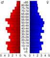
This chart shows the age groups of people living in Gallatin County in 2000.

See also
 In Spanish: Condado de Gallatin (Illinois) para niños
