Junction, Illinois facts for kids
Quick facts for kids
Junction, Illinois
|
|
|---|---|

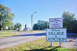
Welcome sign
|
|

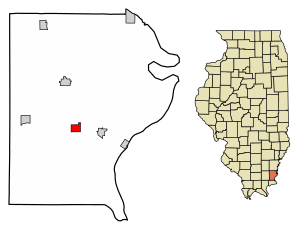
Location of Junction in Gallatin County, Illinois.
|
|

Location of Illinois in the United States
|
|
| Country | United States |
| State | Illinois |
| County | Gallatin |
| Area | |
| • Total | 0.83 sq mi (2.14 km2) |
| • Land | 0.83 sq mi (2.14 km2) |
| • Water | 0.00 sq mi (0.00 km2) |
| Population
(2010)
|
|
| • Total | 129 |
| • Estimate
(2019)
|
111 |
| • Density | 134.38/sq mi (51.88/km2) |
| Time zone | UTC-6 (CST) |
| • Summer (DST) | UTC-5 (CDT) |
| ZIP Code(s) |
62954
|
| Area code(s) | 618 |
| FIPS code | 17-38778 |
Junction is a small village located in Gallatin County, Illinois, in the United States. In 2020, about 56 people lived there.
Contents
A Look at Junction's Past

Junction was first settled in the 1880s. It got its name because it was located where two important railroads met: the L&N and the B&O.
When a post office opened in 1884, it was called "Cypress Junction." Later, in 1888, the name changed to "Junction City." Finally, in 1894, it was shortened to just "Junction."
Because Junction is in a flat area, it can sometimes experience flooding. This happens when the nearby Ohio River overflows, causing water in the Saline River to back up. A big flood in March 1997 forced many people to leave their homes. It also blocked almost all roads into the village.
On June 1, 2022, the Junction General Baptist Church caught fire. This happened after lightning struck its steeple.
The Historic Crenshaw House
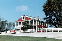
About five miles west of Junction, you can find the Hickory Hill mansion. This old house from the 1800s belonged to John Hart Crenshaw. It was known as the "Old Slave House" because of its connection to the history of slavery.
Where is Junction Located?
Junction is right in the middle of Gallatin County. You can find it at 37°43′22″N 88°14′17″W / 37.72278°N 88.23806°W. The village is along Illinois Route 13. It's just a few miles west of the Ohio River. The Shawnee National Forest is located to the north.
The Saline River, which flows into the Ohio River, passes just south of Junction. In 2010, the village covered about 0.88 square miles (2.14 square kilometers). Most of this area is land, with only a tiny bit being water.
How Many People Live in Junction?
| Historical population | |||
|---|---|---|---|
| Census | Pop. | %± | |
| 1910 | 800 | — | |
| 1920 | 321 | −59.9% | |
| 1930 | 292 | −9.0% | |
| 1940 | 320 | 9.6% | |
| 1950 | 239 | −25.3% | |
| 1960 | 238 | −0.4% | |
| 1970 | 199 | −16.4% | |
| 1980 | 192 | −3.5% | |
| 1990 | 201 | 4.7% | |
| 2000 | 139 | −30.8% | |
| 2010 | 129 | −7.2% | |
| 2020 | 56 | −56.6% | |
| U.S. Decennial Census | |||
According to the 2020 census, 56 people lived in Junction. There were 35 households and 38 families. Most of the people living there, about 92.9%, were White. About 1.79% of the population identified as Hispanic or Latino.
Out of the 35 households, about 10.2% had children under 18 living with them. Most households, 68.6%, were married couples living together. About 22.9% of households were led by a female with no husband present.
The average income for a household in the village was $32,375. For families, the average income was $42,500. Sadly, 45.5% of people over 64 years old were living below the poverty line.
Famous People from Junction
- John Hart Crenshaw, a landowner and salt maker known for his connection to the historic Crenshaw House.
See also
 In Spanish: Junction (Illinois) para niños
 | Jessica Watkins |
 | Robert Henry Lawrence Jr. |
 | Mae Jemison |
 | Sian Proctor |
 | Guion Bluford |

