Omaha, Illinois facts for kids
Quick facts for kids
Omaha, Illinois
|
|
|---|---|

IL 1 in Omaha
|
|

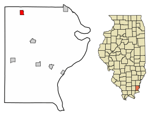
Location of Omaha in Gallatin County, Illinois.
|
|

Location of Illinois in the United States
|
|
| Country | United States |
| State | Illinois |
| County | Gallatin |
| Area | |
| • Total | 0.74 sq mi (1.93 km2) |
| • Land | 0.74 sq mi (1.93 km2) |
| • Water | 0.00 sq mi (0.00 km2) |
| Elevation | 390 ft (120 m) |
| Population
(2020)
|
|
| • Total | 209 |
| • Density | 280.91/sq mi (108.40/km2) |
| Time zone | UTC-6 (CST) |
| • Summer (DST) | UTC-5 (CDT) |
| ZIP Code(s) |
62871
|
| Area code(s) | 618 |
| FIPS code | 17-56003 |
| GNIS ID | 2399573 |
| Wikimedia Commons | Omaha, Illinois |
Omaha is a small village located in Gallatin County, Illinois, in the United States. In 2020, about 209 people lived there.
History of Omaha
Omaha was started in 1871. It was a stop along the Springfield and Illinois South Eastern Railway, a train line. A man named Henry Pearce, who worked for the railroad, gave the village its name. He had worked in Omaha, Nebraska before, and he named the new village after that city.
Omaha first tried to become an official village (this is called incorporation) in 1875, but it didn't work. They tried again later, and Omaha officially became a village in 1888.
This area is known for its many strawberry farms. Omaha used to have a special "Strawberry Day" celebration every May. The village is also famous in Southern Illinois for "Omaha Furniture," a large and popular furniture store that has been open since 1932.
Where is Omaha?
Omaha is in the northwestern part of Gallatin County. You can find it at these coordinates: 37°53′24″N 88°18′12″W / 37.89000°N 88.30333°W.
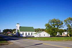
Illinois Route 1 is a main road that goes through the village. If you go north on this road for about 7 miles (11 km), you'll reach Norris City. If you go south for about 32 miles (51 km), you'll get to Cave-in-Rock on the Ohio River. Shawneetown, which is the main town of Gallatin County, is about 16 miles (26 km) to the southeast. You can get there by taking Routes 1 and 13.
In 2021, Omaha covered a total area of about 0.75 square miles (1.94 km2). Almost all of this area, about 0.74 square miles (1.92 km2), is land. A very small part, about 0.00 square miles (0.00 km2), is water.
People in Omaha
| Historical population | |||
|---|---|---|---|
| Census | Pop. | %± | |
| 1880 | 187 | — | |
| 1890 | 428 | 128.9% | |
| 1900 | 569 | 32.9% | |
| 1910 | 586 | 3.0% | |
| 1920 | 449 | −23.4% | |
| 1930 | 358 | −20.3% | |
| 1940 | 413 | 15.4% | |
| 1950 | 394 | −4.6% | |
| 1960 | 312 | −20.8% | |
| 1970 | 304 | −2.6% | |
| 1980 | 295 | −3.0% | |
| 1990 | 273 | −7.5% | |
| 2000 | 263 | −3.7% | |
| 2010 | 266 | 1.1% | |
| 2020 | 209 | −21.4% | |
| U.S. Decennial Census | |||
According to the 2020 census, 209 people lived in Omaha. There were 91 households, which means 91 different homes or families. The population density was about 280.54 inhabitants per square mile (108.32/km2). This tells us how many people live in each square mile. There were 116 housing units, like houses or apartments.
Most people in the village, about 95.22%, were identified as White. A small number, 0.48%, were Asian, and 4.31% were from two or more races.
The average income for a household in Omaha was $54,107 per year. For families, the average income was $71,250. About 14.9% of the people in Omaha lived below the poverty line. This included 17.6% of those under 18 years old and 12.3% of those aged 65 or older.
Famous People from Omaha
- Nathan D. Bryant (1869–1949) was a person who lived in Omaha during his time in politics. He was a member of the Illinois House of Representatives, which is a group of people who make laws for the state of Illinois.
See also
 In Spanish: Omaha (Illinois) para niños
 | Leon Lynch |
 | Milton P. Webster |
 | Ferdinand Smith |


