Grayville, Illinois facts for kids
Quick facts for kids
Grayville
|
|
|---|---|

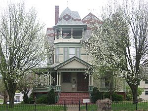
The William W. Gray House, a local landmark
|
|

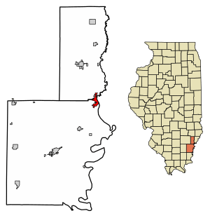
Location of Grayville in Edwards County, Illinois.
|
|

Location of Illinois in the United States
|
|
| Country | United States |
| State | Illinois |
| County | Edwards, White |
| Area | |
| • Total | 2.17 sq mi (5.62 km2) |
| • Land | 2.13 sq mi (5.51 km2) |
| • Water | 0.04 sq mi (0.11 km2) |
| Elevation | 423 ft (129 m) |
| Population
(2020)
|
|
| • Total | 1,550 |
| • Density | 728.73/sq mi (281.34/km2) |
| Time zone | UTC-6 (CST) |
| • Summer (DST) | UTC-5 (CDT) |
| ZIP Code(s) |
62844
|
| Area code(s) | 618 |
| FIPS code | 17-31165 |
| GNIS ID | 2394970 |
| Wikimedia Commons | Grayville, Illinois |
| Website | https://grayville-il.gov/ |
Grayville is a small city located in Illinois, a state in the United States. It sits across two counties: Edwards County and White County. In 2020, about 1,550 people lived there. This was a small decrease from its population of 1,666 in 2010. Grayville is also known as the hometown of James Meredith Helm, a brave naval hero.
Contents
History of Grayville
Grayville was started around 1810 by a person named James Gray and his family. The city became very important because of its oil. Many people moved there to drill for oil. In the 1950s, the number of people living in Grayville began to go down. However, unlike some other oil towns in Illinois, Grayville has continued to do well.
Geography of Grayville
Grayville is located at a specific spot on the Earth: 38°15′33″N 87°59′48″W / 38.25917°N 87.99667°W. This means it is at 38.259146 degrees north and -87.996678 degrees west.
The city covers a total area of about 2.17 square miles (5.62 square kilometers). Most of this area, about 2.13 square miles (5.51 square kilometers), is land. The rest, about 0.04 square miles (0.11 square kilometers), is water.
Grayville's Climate
Grayville has a climate with warm summers and cold winters. The weather changes quite a bit throughout the year. Here is a summary of the average temperatures and precipitation:
| Climate data for Grayville, Illinois (1991–2020) | |||||||||||||
|---|---|---|---|---|---|---|---|---|---|---|---|---|---|
| Month | Jan | Feb | Mar | Apr | May | Jun | Jul | Aug | Sep | Oct | Nov | Dec | Year |
| Mean daily maximum °F (°C) | 41.2 (5.1) |
45.0 (7.2) |
55.7 (13.2) |
67.6 (19.8) |
77.5 (25.3) |
85.7 (29.8) |
88.6 (31.4) |
87.6 (30.9) |
82.2 (27.9) |
70.1 (21.2) |
56.3 (13.5) |
44.8 (7.1) |
66.9 (19.4) |
| Daily mean °F (°C) | 32.4 (0.2) |
35.4 (1.9) |
45.3 (7.4) |
56.2 (13.4) |
66.3 (19.1) |
75.1 (23.9) |
78.1 (25.6) |
76.2 (24.6) |
69.8 (21.0) |
57.8 (14.3) |
46.0 (7.8) |
36.2 (2.3) |
56.2 (13.5) |
| Mean daily minimum °F (°C) | 23.6 (−4.7) |
25.8 (−3.4) |
34.9 (1.6) |
44.8 (7.1) |
55.2 (12.9) |
64.5 (18.1) |
67.6 (19.8) |
64.8 (18.2) |
57.3 (14.1) |
45.5 (7.5) |
35.7 (2.1) |
27.6 (−2.4) |
45.6 (7.6) |
| Average precipitation inches (mm) | 3.22 (82) |
3.80 (97) |
4.59 (117) |
4.52 (115) |
5.75 (146) |
4.46 (113) |
5.28 (134) |
3.64 (92) |
3.72 (94) |
3.90 (99) |
3.35 (85) |
3.77 (96) |
50 (1,270) |
| Average snowfall inches (cm) | 2.3 (5.8) |
4.6 (12) |
0.2 (0.51) |
0.0 (0.0) |
0.0 (0.0) |
0.0 (0.0) |
0.0 (0.0) |
0.0 (0.0) |
0.0 (0.0) |
0.0 (0.0) |
0.0 (0.0) |
4.7 (12) |
11.8 (30.31) |
| Source: NOAA | |||||||||||||
Transportation and Roads
Grayville is an important meeting point for several roads. Illinois Route 130 and Illinois Route 1 both meet here. Also, Interstate 64 connects with Route 1 in Grayville.
The city was built near the Wabash River. There used to be a large train bridge across the Wabash River that connected Illinois to Indiana. However, parts of this bridge fell down in January 2005 during a big flood.
Later in 2005, there was a plan to build an ethanol plant in the Grayville area. This project would have included rebuilding the train bridge and the rail lines. But as of July 2009, neither the plant nor the bridge have been built.
The largest bridge to Indiana south of Lawrenceville is the I-64 river crossing. It runs next to where the old train bridge used to be. This is the only Interstate connection between Illinois and Indiana south of Terre Haute.
Population of Grayville
The number of people living in Grayville has changed over many years. Here is a look at the population from different census counts:
| Historical population | |||
|---|---|---|---|
| Census | Pop. | %± | |
| 1880 | 1,533 | — | |
| 1890 | 1,999 | 30.4% | |
| 1900 | 1,948 | −2.6% | |
| 1910 | 1,940 | −0.4% | |
| 1920 | 1,749 | −9.8% | |
| 1930 | 1,904 | 8.9% | |
| 1940 | 2,240 | 17.6% | |
| 1950 | 2,461 | 9.9% | |
| 1960 | 2,280 | −7.4% | |
| 1970 | 2,035 | −10.7% | |
| 1980 | 2,313 | 13.7% | |
| 1990 | 2,043 | −11.7% | |
| 2000 | 1,725 | −15.6% | |
| 2010 | 1,666 | −3.4% | |
| 2020 | 1,550 | −7.0% | |
| U.S. Decennial Census | |||
In 2020, Grayville had 1,550 residents living in 680 households. About 400 of these were families. The city had about 714 people per square mile. Most of the people living in Grayville were White (94.45%). A small number were African American, Native American, Asian, Pacific Islander, or from other races. Some residents (1.61%) identified as Hispanic or Latino.
About 32.4% of households had children under 18 living with them. Many households (43.24%) were married couples. The average household size was about 2.78 people. The average family size was 2.24 people.
The median age in Grayville was 40.5 years. This means half the people were younger than 40.5 and half were older. About 22.4% of the population was under 18 years old. About 20.1% of the population was 65 years or older.
The average income for a household in Grayville was $47,222. For families, the average income was $58,333. About 14.0% of families and 20.5% of all people lived below the poverty line. This included 29.5% of those under 18.
The Wabash River's Change
Grayville used to be at the northern end of a long, curving part of the Wabash River. This curve was like an "oxbow" shape. However, the river changed its path after a big flood in 1985. Now, the main river channel is about two miles away from the town.
A smaller stream called Bonpas Creek now flows through part of the old river channel. This still allows for small boats like canoes and rafts to use the water.
See also
 In Spanish: Grayville para niños
 | May Edward Chinn |
 | Rebecca Cole |
 | Alexa Canady |
 | Dorothy Lavinia Brown |

