Griffin, Indiana facts for kids
Quick facts for kids
Griffin, Indiana
|
|
|---|---|
| Town of Griffin | |
 |
|

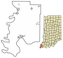
Location of Griffin in Posey County, Indiana.
|
|
| Country | United States |
| State | Indiana |
| County | Posey |
| Township | Bethel |
| Area | |
| • Total | 0.07 sq mi (0.18 km2) |
| • Land | 0.07 sq mi (0.18 km2) |
| • Water | 0.00 sq mi (0.00 km2) |
| Elevation | 384 ft (117 m) |
| Population
(2020)
|
|
| • Total | 143 |
| • Density | 2,102.94/sq mi (807.58/km2) |
| Time zone | UTC-6 (CST) |
| • Summer (DST) | UTC-5 (CDT) |
| ZIP code |
47616
|
| Area code(s) | 812, 930 |
| FIPS code | 18-30024 |
| GNIS feature ID | 2396978 |
Griffin is a small town located in Bethel Township, Posey County, in the U.S. state of Indiana. In 2020, the population was 143 people.
Contents
History of Griffin
Griffin was first known as Price's Station. It was officially started in 1881 by William Price. The town was named after him.
Later, the name changed to Griffin. This new name honored Samuel Griffin, who was an early postmaster. A post office has been operating in Griffin since 1881.
The 1925 Tornado
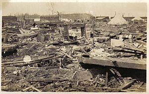
On March 18, 1925, a very powerful tornado hit Griffin. This tornado was part of the 1925 Tri-State tornado outbreak. It caused a lot of damage and destroyed the town. Sadly, 44 people lost their lives, and over 200 people were hurt.
The Bull Island Rock Fest
In 1972, a large outdoor rock concert took place near Griffin. It was called the Erie Canal Soda Pop Festival. Locally, people called it the Bull Island rock fest. This event caused a lot of excitement in the town for three days.
Geography of Griffin
Griffin is located in Indiana at these coordinates: 38.204406 degrees North and 87.915033 degrees West.
According to the 2010 census, Griffin covers a total area of about 0.07 square miles (0.18 square kilometers). All of this area is land.
Population and People
| Historical population | |||
|---|---|---|---|
| Census | Pop. | %± | |
| 1910 | 275 | — | |
| 1920 | 341 | 24.0% | |
| 1930 | 208 | −39.0% | |
| 1940 | 386 | 85.6% | |
| 1950 | 249 | −35.5% | |
| 1960 | 212 | −14.9% | |
| 1970 | 178 | −16.0% | |
| 1980 | 192 | 7.9% | |
| 1990 | 171 | −10.9% | |
| 2000 | 160 | −6.4% | |
| 2010 | 172 | 7.5% | |
| 2020 | 143 | −16.9% | |
| U.S. Decennial Census | |||
Griffin's Population in 2010
In 2010, there were 172 people living in Griffin. These people lived in 69 households. About 51 of these households were families.
Most of the people in Griffin were White (98.8%). A small number were African American (0.6%) or from two or more races (0.6%).
About 33.3% of households had children under 18 living there. Many households (62.3%) were married couples. The average household had about 2.49 people. The average family had about 2.94 people.
The average age of people in Griffin was 37.3 years old. About 26.2% of residents were under 18. About 15.1% were 65 years old or older. More females lived in Griffin (57.0%) than males (43.0%).
Education in Griffin
The schools in Griffin and the northern part of Posey County are managed by the MSD of North Posey County. This school district currently runs four schools:
- North Posey High School (for grades 9-12)
- North Posey Junior High School (for grades 7-8)
- North Elementary School (for grades K-6)
- South Terrace Elementary School (for grades K-6)
Before 1959, Griffin had its own high school. The school's colors were red and white. Their mascot was the Tornadoes, named after the famous Tri-State tornado outbreak. In 1959, this high school joined with North Posey High School.
Highways Near Griffin
See also
 In Spanish: Griffin (Indiana) para niños
 | DeHart Hubbard |
 | Wilma Rudolph |
 | Jesse Owens |
 | Jackie Joyner-Kersee |
 | Major Taylor |


