Wadesville, Indiana facts for kids
Quick facts for kids
Wadesville, Indiana
|
|
|---|---|
 |
|
| Country | United States |
| State | Indiana |
| County | Posey |
| Township | Center |
| Elevation | 456 ft (139 m) |
| Time zone | UTC-6 (Central (CST)) |
| • Summer (DST) | UTC-5 (CDT) |
| ZIP code |
47638
|
| Area code(s) | 812, 930 |
| GNIS feature ID | 2830503 |
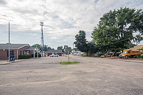
Wadesville is a small community in Posey County, Indiana. It's known as an unincorporated area, which means it doesn't have its own city government. You can find Wadesville in northern Center Township. It's located along State Road 66. Even without a city government, Wadesville has its own post office with the ZIP code 47638.
The U.S. Census Bureau has even created a special area for Wadesville. This helps them count the people living there.
Contents
Wadesville's Early Days
Wadesville was officially started in 1852. The community got its name from the Wade family. They were some of the first settlers in the area. A post office has been serving Wadesville residents since 1855.
Wadesville High School History
Wadesville used to have its own high school. The school's sports teams were called the "Wadesville Red Devils." Students from first grade all the way to twelfth grade attended this school. The school's yearbook was named the "Devilree."
In 1958, Wadesville High School joined with other local schools. These included schools from Poseyville, Cynthiana, and Griffin. Together, they formed the new North Posey High School.
Red Devil Athletics: Sports Success
The Wadesville Red Devils had school colors of white and red. They competed in the Posey County Conference. This was a group of local schools that played against each other in sports.
The Red Devils had a great final season in 1958. Their basketball team finished with 11 wins and 9 losses. They even won the Posey County Conference tournament! They beat Cynthiana with a score of 81–59 in the championship game. The Red Devils also won the Posey County Conference in baseball that same year.
Education in Wadesville Today
Today, students in the Wadesville area attend schools in the Metropolitan School District of North Posey County. This school district includes several schools for different age groups.
The district has two elementary schools: North Elementary and South Terrace Elementary. There is also North Posey Junior High School. Older students attend North Posey High School.
South Terrace Elementary School is located in Blairsville. This is about 2 miles (3.2 km) southeast of Wadesville. Plans for building this school started in the fall of 1957. It was designed to have 10 classrooms.
Main Roads in Wadesville
 | Emma Amos |
 | Edward Mitchell Bannister |
 | Larry D. Alexander |
 | Ernie Barnes |


