Delaware County, Indiana facts for kids
Quick facts for kids
Delaware County
|
||
|---|---|---|

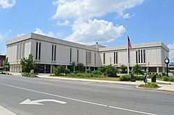
Delaware County Building
|
||
|
||

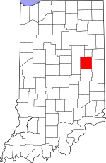
Location within the U.S. state of Indiana
|
||
 Indiana's location within the U.S. |
||
| Country | ||
| State | ||
| Founded | 1820 (created) 1827 (organized) |
|
| Seat | Muncie | |
| Largest city | Muncie | |
| Area | ||
| • Total | 395.91 sq mi (1,025.4 km2) | |
| • Land | 392.12 sq mi (1,015.6 km2) | |
| • Water | 3.78 sq mi (9.8 km2) 0.95%% | |
| Population
(2020)
|
||
| • Total | 111,903 | |
| • Estimate
(2021)
|
111,355 |
|
| • Density | 282.648/sq mi (109.1308/km2) | |
| Time zone | UTC−5 (Eastern) | |
| • Summer (DST) | UTC−4 (EDT) | |
| Congressional district | 6th | |
| Indiana county number 18 | ||
Delaware County is a county located in the east-central part of Indiana, a state in the United States. A county is like a smaller region within a state, often with its own local government. In 2020, about 111,903 people lived here. The main city and government center of the county is Muncie.
Delaware County is part of a larger area called the Muncie metropolitan statistical area. This means Muncie and the surrounding county are connected by jobs and daily life. It's also part of an even bigger area called the Indianapolis-Carmel-Muncie CSA, which stands for Combined Statistical Area. This just means it's part of a very large region with many cities and towns that are linked together.
Contents
History
Delaware County was officially created in January 1820. This happened on land that the U.S. government bought from Native American tribes in 1818. This land was called the "New Purchase." The county is named after the Delaware people, a Native American tribe who used to live along the White River in this area.
Sadly, the Delaware people were later moved to lands west of the Mississippi River in the 1840s. A famous Native American leader named Tenskwatawa, also known as "The Prophet," once lived in this county. He was the brother of another well-known leader, Tecumseh.
The first white settler in the area was a trader named David Conner, who arrived in the early 1810s. After Delaware County was first created, many other counties were formed from its original land. The part that kept the name "Delaware County" was officially organized in 1827.
After the American Civil War, the county's economy grew a lot. This was because natural gas was discovered, which led to many new factories and businesses.
The first time natural gas was found in Indiana was in 1876 near Eaton. A company was drilling for coal when they hit something at 600 feet. There was a loud noise and bad-smelling fumes came out! People thought they had drilled into "Hell" and quickly filled the hole. But in 1884, when natural gas was found in nearby Ohio, people remembered the incident. They went back to the spot and opened Indiana's first natural gas well. The gas was so strong that when it was lit, the flames could be seen all the way from Muncie!
Geography
Delaware County has gently rolling land, with many rivers and streams. The Mississinewa River flows through the northern part of the county, and the White River runs through the middle, passing through Muncie. There's also a large lake called Prairie Creek Reservoir southeast of Muncie, which the city manages. The soil in the county is very good for farming. The highest point in the county is a hilly area in its southeast corner.
The county covers about 395.91 square miles. Most of this (about 392.12 square miles) is land, and a small part (about 3.78 square miles) is water.
Major highways
Adjacent counties
- Blackford County - north
- Jay County - northeast
- Randolph County - east
- Henry County - south
- Madison County - west
- Grant County - northwest
Cities and towns
Unincorporated communities
Townships
- Center
- Delaware
- Hamilton
- Harrison
- Liberty
- Monroe
- Mount Pleasant
- Niles
- Perry
- Salem
- Union
- Washington
Climate and weather
| Weather chart for Muncie, Indiana | |||||||||||||||||||||||||||||||||||||||||||||||
|---|---|---|---|---|---|---|---|---|---|---|---|---|---|---|---|---|---|---|---|---|---|---|---|---|---|---|---|---|---|---|---|---|---|---|---|---|---|---|---|---|---|---|---|---|---|---|---|
| J | F | M | A | M | J | J | A | S | O | N | D | ||||||||||||||||||||||||||||||||||||
|
2.1
33
16
|
2.3
38
20
|
3.1
48
29
|
3.6
61
39
|
4.2
72
51
|
4.3
81
60
|
4
85
64
|
3.5
83
62
|
3
76
54
|
2.6
64
42
|
3.4
50
33
|
3
38
22
|
||||||||||||||||||||||||||||||||||||
| temperatures in °F precipitation totals in inches source: The Weather Channel |
|||||||||||||||||||||||||||||||||||||||||||||||
|
Metric conversion
|
|||||||||||||||||||||||||||||||||||||||||||||||
In Muncie, the average temperatures usually range from about 16°F (about -9°C) in January to 85°F (about 29°C) in July. The coldest temperature ever recorded was -29°F (about -34°C) in January 1994. The hottest was 102°F (about 39°C) in June 1988.
The amount of rain and snow changes throughout the year. On average, January gets about 2.06 inches of precipitation, while June gets the most, with about 4.28 inches.
Demographics
| Historical population | |||
|---|---|---|---|
| Census | Pop. | %± | |
| 1820 | 3,677 | — | |
| 1830 | 2,374 | −35.4% | |
| 1840 | 8,843 | 272.5% | |
| 1850 | 10,843 | 22.6% | |
| 1860 | 15,753 | 45.3% | |
| 1870 | 19,030 | 20.8% | |
| 1880 | 22,926 | 20.5% | |
| 1890 | 30,131 | 31.4% | |
| 1900 | 49,624 | 64.7% | |
| 1910 | 51,414 | 3.6% | |
| 1920 | 56,377 | 9.7% | |
| 1930 | 67,270 | 19.3% | |
| 1940 | 74,963 | 11.4% | |
| 1950 | 90,252 | 20.4% | |
| 1960 | 110,938 | 22.9% | |
| 1970 | 129,219 | 16.5% | |
| 1980 | 128,587 | −0.5% | |
| 1990 | 119,659 | −6.9% | |
| 2000 | 118,769 | −0.7% | |
| 2010 | 117,671 | −0.9% | |
| 2020 | 111,903 | −4.9% | |
| 2023 (est.) | 112,321 | −4.5% | |
| US Decennial Census 1790-1960 1900-1990 1990-2000 2010-2019 |
|||
The U.S. Census counts how many people live in an area and gathers information about them.
2020 Census
In 2020, there were 111,903 people living in Delaware County. There were also 46,026 households, which are groups of people living together in one home.
Most of the people in the county (88.7%) were white. About 7.2% were African American, and 1.3% were Asian. About 2.6% of the people were Hispanic or Latino.
When looking at age groups:
- 4.8% of the population were 5 years old or younger.
- 18.2% were under 18 years old.
- 64.3% were between 18 and 64 years old.
- 17.5% were 65 years old or older.
Slightly more than half of the population (51.8%) were female, and 48.2% were male. The average household had about 2.34 people.
Many homes in Delaware County have computers (88.1%), and most (78.3%) have a fast internet connection. About 58.5% of the people were working or looking for jobs. The average income for a household in Delaware County was $43,512 per year.
See also
 In Spanish: Condado de Delaware (Indiana) para niños
 | Aurelia Browder |
 | Nannie Helen Burroughs |
 | Michelle Alexander |


